
 Yahoo Movies
 Winter storm watch issued for the Midlands with ice and snow in the forecast
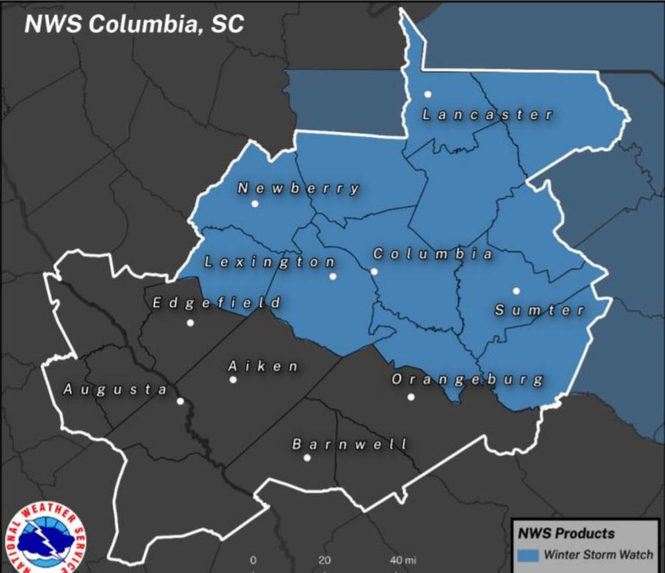
A winter storm watch has been issued for much of the Midlands, as freezing rain and snow are forecast this week.
The watch goes into effect Thursday night, when the precipitation is expected to begin. The watch for the Columbia area is in place through 7 a.m. Saturday, according to the National Weather Service.
“This is the typical southern winter weather event,” National Weather Service meteorologist Matt Gropp told The State Wednesday. “It’s hard to predict, but there will be a mixed bag of (precipitation) that includes rain, freezing rain, sleet and snow.”
Freezing rain is expected to affect a larger portion of the Midlands than any other winter weather elements, but both sleet and snow are possible for large swaths of the region, according to the National Weather Service.
The watch covers Richland County and Lexington County, but also includes Kershaw, Newberry, Fairfield, Saluda, Lee, Sumter, Calhoun, Clarendon, Chesterfield, and Lancaster counties.
Because temperatures are expected to drop below freezing Friday morning, winter weather elements beyond rain are expected, Gropp said. The possible high Friday is 34 degrees, while lows in the mid 20s are expected at night, the forecast shows.
Any freezing rain or snow will be caused by a cold front that’s moving through the area, and bringing in arctic air behind it, according to the National Weather Service.
Freezing rain could begin Thursday night when there is a 60% chance of precipitation, while snow and sleet are likely expect to start falling on Friday, the National Weather Service said.
Some portions of the northern Midlands could get one or two inches of snow, but about half an inch is possible in the Columbia area, according to the watch.
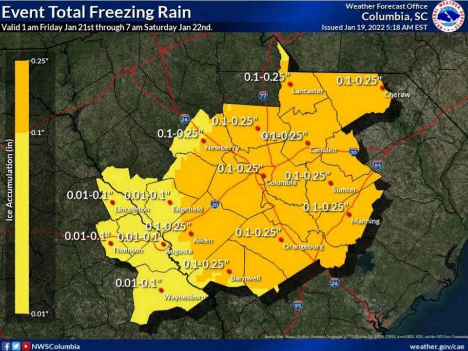
One tenth to a quarter inch of ice accumulation is also possible, the National Weather Service said.

Ice accumulation of a quarter inch was common across the Midlands during freezing rain that happened last Sunday, according to the National Weather Service. Higher amounts were recorded in areas with prolonged exposure to freezing rain.
If enough ice or snow accumulates this time, that could again cause considerable damage to trees and branches, which creates the possibility of more downed power lines and outages.
More than 100,000 outages were reported by power customers in South Carolina last Sunday, and nearly half of those were in the Midlands.
Freezing rain, sleet, or snow can cause safety issues on the roads. The National Weather Service said to plan on slippery and hazardous road conditions.
“The timing of this storm isn’t great because there will be freezing rain during rush hour on Friday,” Gropp said.
Last weekend drivers were asked to stay off the roads if possible. That request could be issued again.
Black ice will be a threat late Saturday night and into Sunday morning, as there could be freezing, followed by warmer temperatures, and more freezing, the National Weather Service said.
Black ice is difficult to see and makes roads very slippery, especially bridges and overpasses. Black ice forms when snow or light rain falls on frozen concrete or asphalt, freezing quickly to form a layer of ice that is almost invisible against the backdrop of blacktop roads.
“Stay weather aware,” Gropp warned.
This would be the second winter storm in less than a week after a warmer than normal December and early January.
While rain and freezing rain were the predominant forms of precipitation in the storm last Sunday, a trace amount of snow was confirmed at Columbia Metropolitan Airport, according to the National Weather Service. That marked the first time since Jan. 16, 2018, that snow was recorded in Columbia.
The last measurable snowfall at the airport was on Jan. 6, 2017, when about a tenth of an inch was recorded, the National Weather Service said.

