
 Yahoo Movies
 Wildfire updates: Cal Fire eyes red flag warning for eastern Sierra Nevada
A red flag warning issued for the eastern slope of the Sierra Nevada early next week could mean increased fire activity as major wildfires throughout Northern California continue to burn.
The red flag warning, issued by the National Weather Service’s Reno office, is set to cover the far side of the Sierra Nevada from Mono County to the Oregon state border. Most of the warning covers territory in western Nevada, including the city of Reno and surrounding areas, but South Lake Tahoe and other Tahoe Basin communities are included.
Set to take effect at 11 a.m. Monday and last through Tuesday at 5 a.m., Reno meteorologists predict fast-moving southwesterly winds with gusts up to 40 mph possible.
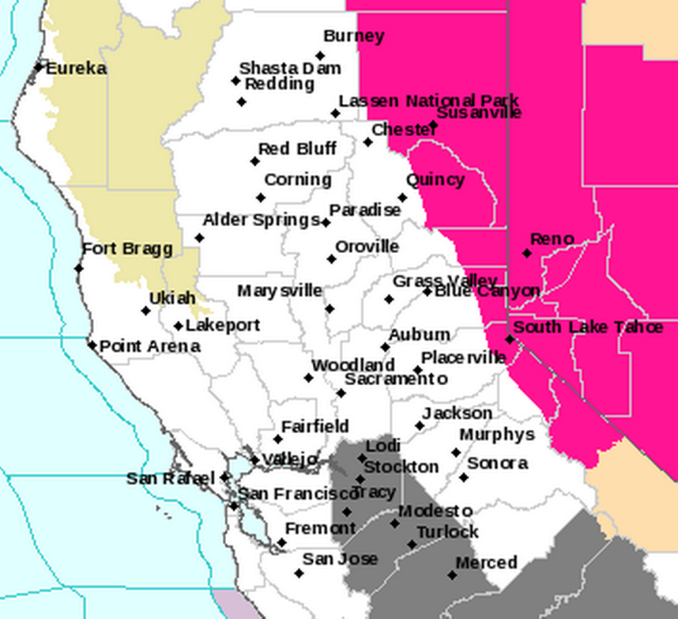
Another cause for concern is relatively low humidity levels. The Weather Service said that areas east of Highway 395 — which runs along the eastern edge of California and crosses into Nevada through Reno — could see humidity levels between 15% and 20%.
The Reno weather office warned that low humidity plus gusty winds means fires could start and rapidly spread before fire crews have a chance to contain them.
Cal Fire responded to the red flag warning on social media by warning residents in affected areas to take special precautions while outdoors amid high fire danger.
Caldor Fire
The U.S. Forest Service is expecting that winds in the area of the Caldor Fire will range between 30 and 40 mph. The fire, now mostly contained but still highly active, has burned 221,774 acres. It is California’s 14th-largest wildfire and is 76% contained.
“Fire operations is watching this weather front closely and its potential impact on the fire,” the Forest Service said in a Sunday morning update.
On Saturday, some crews were diverted from the Caldor Fire in order to fight a new fire that ignited near Ellicott Bridge on the Rubicon River. Dubbed the Rubicon Fire, it was about 7 acres Saturday afternoon. The Forest Service said crews surrounded it and were working on mopping it up by Saturday night, but would need to be monitored for several days to secure its edges.
Other areas on the western flank of the Caldor Fire remain active, and many communities remain under evacuation orders due to nearby fire activity, including some of the areas surrounding Lake Tahoe.
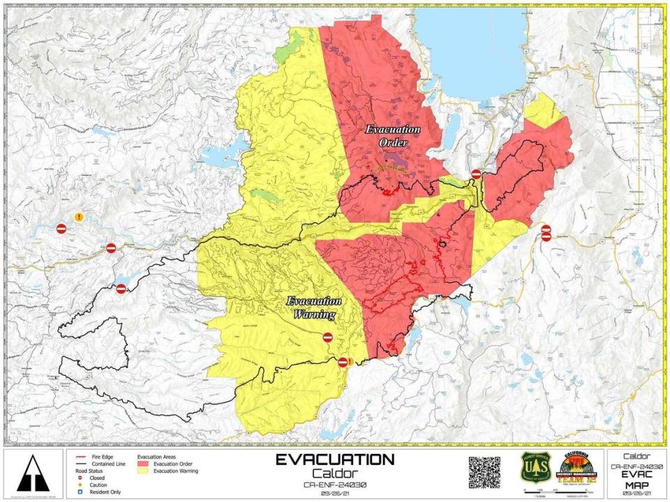
The Caldor Fire started Aug. 14 just east of Omo Ranch and since then has forced thousands to evacuate from their homes in rural, wooded areas of El Dorado County, as well as from South Lake Tahoe.
The Forest Service said that 1,353 structures still remain threatened by the blaze, which has destroyed 782 homes and damaged 81 additional structures. Much of the town of Grizzly Flats was destroyed by the fire in mid-August.
A total of 1,508 fire personnel are assigned to the Caldor, with the assistance of 10 helicopters.
Dixie Fire
Although parts of the eastern flank of the Dixie Fire are included in the red flag warning, crews have nearly achieved full containment.
At 963,276 acres and 94% containment, the Dixie Fire is the second-largest wildfire in California state history. Even though the massive blaze hasn’t spread much in recent weeks, fire crews still aren’t taking any chances with hazardous weather.
“With low humidity, warm temperatures, dry fuels, and gusty southwest winds, recently fallen needle cast has the potential to reburn from remaining hotspots in the interior of the fire,” Forest Service officials said in a Sunday morning update. “Any spotting outside of the containment lines will have high potential for substantial fire growth today (which) could become established and produce substantial growth.”
To prepare for the incoming winds, Forest Service officials said that crews will be patrolling lines and strengthening forces on the uncontained area at the far northern tip of the fire. The last remaining uncontained area is near Hat Creek Rim in the Lassen National Forest.
Crews are expecting the peak winds to come on Monday, but pass by Tuesday as cooler and wetter weather is predicted for the area.
The Dixie Fire has destroyed 1,329 structures to date, and damaged 95 more. The wildfire destroyed most of Greenville in early August. The fire started on July 13.

