
 Yahoo Movies
 Plummeting temperatures, winds whip up snow squalls in parts of Ontario

Following the cold front that brought widespread, strong winds to southern Ontario on Saturday, temperatures continue to tumble below the normal mark. This cold air coupled with persistent westerly winds has resulted in bursts of lake-effect snow for parts of the province, possibly lingering into Sunday afternoon before weakening. We’re left with a bitter chill to finish out the first weekend of December, but temperatures will see a bit of rebound on Monday.
Visit our Complete Guide to Winter 2022/23 for an in-depth look at the Winter Forecast, tips to plan for it, and much more!
Saturday was officially the windiest day for Toronto international airport since May, with a 80 km/h gust recorded in the afternoon as a strong cold front crossed southern Ontario. The last time it was a windier day in Toronto? The destructive May derecho event, which clocked winds of 121 km/h.
Some of the top gusts reached over 100 km/h near the shores of Lake Erie, with Port Colborne hitting 115 km/h. Peterborough Airport also registered a gust exceeding 100 km/h (107 km/h).

Tens of thousands of customers were left without power across southern Ontario as temperatures plummeted, triggering snow squalls through the snowbelts.
Westerly and northwesterly winds prompted some lake-effect snow bands off of Huron and Georgian Bay. While most have diminished, a band off of Georgian Bay continues Sunday morning and will gradually weaken by the afternoon.
Weather advisories are in effect for communities along the north side of the bay. Areas east of Georgian Bay, will likely see up to 10 cm of freshly fallen snow before the afternoon. Visibility can drop rapidly from clear to near-whiteout during a snow squall.
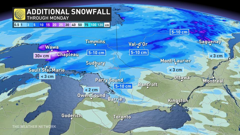
Another, more significant band has been locked in place east of Lake Superior, carrying the potential to dump up to 50 cm of snow -- impacting a stretch of Highway 17 through this weekend. Heavy snow and reduced visibility will be continuing into Monday morning before conditions improve.
DON'T MISS: Worried about a power outage? How to prep ahead of time
Much of the region will see a bounce back to seasonal and sunny conditions to kick-start the work week, but a couple rounds of unsettled weather will return Monday night through Wednesday. At this point it doesn’t look like we will see a major or well-organized system. Mostly rain is expected across southern areas.
The arrival of a more consistently cold pattern looks to be delayed, but not denied. The global pattern still looks very favourable for a cold pattern for southern Ontario in mid- and late December.
Stay tuned to The Weather Network for the latest forecast updates in southern Ontario.
