
 Yahoo Movies
 Where will Ian make landfall after intensifying in the Gulf? ‘Significant uncertainty.’
Tropical Storm Ian likely will rapidly intensify into a major hurricane once the storm moves over the warm Gulf of Mexico, but weather officials on Sunday can’t say with confidence where landfall will be in the U.S.
“Once the cyclone emerges over the southeastern Gulf of Mexico, the spread in the track guidance increases at days 3-5,” the National Hurricane Center in Miami said at 10 a.m. CST. “There is still significant uncertainty in the long-range track forecast of Ian, and future adjustments to this portion of the forecast will likely be required.”
Ian is expected to make a turn northwest later Sunday as the tropical storm passes southwest of Jamaica, then it will begin moving in a north-northwestern motion. The center of Ian is expected to be west of Cayman Islands on Monday and “near or over western Cuba by early Tuesday,” the NHC said.
A hurricane warning is in effect for Western Cuba.
The storm had maxiumum sustaned winds at 1 p.m. CST and likely will become a hurricane Sunday night or early Monday, and NHC forecasters are confident that Ian will strengthen into a Category 3 or 4 hurricane as the storm moves through the Caribbean and into Gulf.
“The intensity guidance remains very aggressive with strengthening Ian, and the NHC forecast reflects this potential,” the hurricane center said.
Ian’s track and the ‘cone of uncertainty’
The predicted track for Ian shifted west multiple times Saturday as the storm gained strength and got better organized.
The 10 a.m. CST update from the NHC shows that Ian is expected to spend more than 48 hours in the Gulf of Mexico before a landfall, possibly somewhere near the Florida panhandle.
Most of Florida, excluding the southern part of the state, is currently in the “cone of uncertainty.” Exact landfall is not known, and weather officials say the entire Gulf Coast region should be on alert.
“All eyes from central Gulf Coast to the spine of Florida should remain vigilant and prepared to spring to action,” Weather Channel Meteorologist Scot Pilié said.
Ian expected to weaken before landfall
Ian will be a major hurricane for most of the storm’s time in the Gulf, but forecasters do believe it will weaken to a Category 2 storm before landfall.
“A significant increase in southwesterly shear is forecast by the global models, and this is forecast to induce some weakening as the vertical structure of the hurricane is disrupted,” the NHC said.
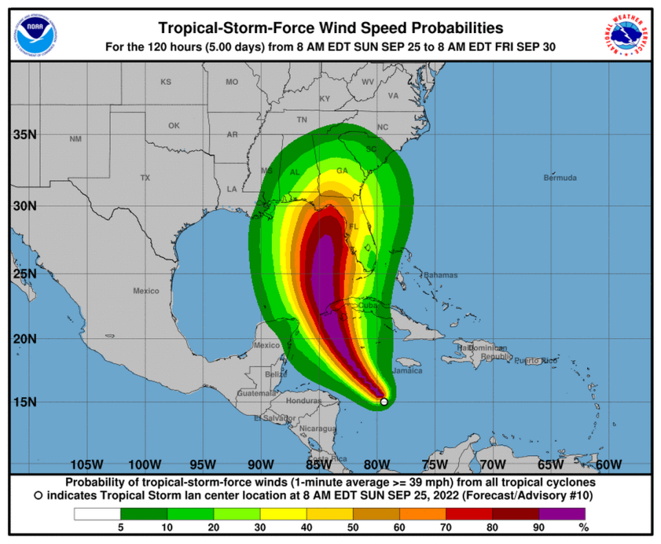
The entire Mississippi Coast, southern Alabama, parts of Georgia and South Carolina and all of Florida will feel tropical storm or hurricane force winds from Ian, according to the forecast.
“Ian is likely to have an expanding wind field and will be slowing down by that time, which will have the potential to produce significant wind and storm surge impacts across portions of the Florida west coast and the Florida panhandle,” the NHC said.
The NHC provides updates on Tropical Storm Ian every three hours.
