
 Yahoo Movies
 Two snowstorms to hit Boise, snow will stick to roadways. Here’s what to expect this weekend
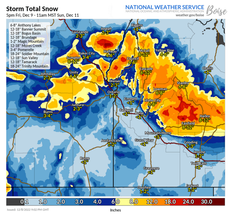
Two storm systems will move into the Treasure Valley this weekend, dropping around 2 inches of snow in Boise and much more in the mountains.
The National Weather Service issued a winter weather advisory for much of Central Idaho and southward to the Owyhee Mountains until 5 p.m. Friday, including Boise. The advisory warns of snow accumulations of half an inch to 2 inches in the valleys and 3 to 5 inches in the mountains, with higher peaks receiving as much as 8 inches.
Weather Service meteorologist Mike Cantin told the Idaho Statesman on Thursday that he expects about an inch to fall in Boise overnight Thursday into Friday morning, with snow starting between 8 and 10 p.m.
“The timing of this with the cold ground we’ve had of late, we expect that the snowfall is going to stick, and so expect things to get slippery pretty fast,” Cantin said.
The majority of that snowfall will come between 2 and 6 a.m., ahead of peak commuting hours, Cantin said, meaning side streets will be especially slippery until plows can get to them or the snow melts away.

But those waiting for the snow to melt will have to wait until at least Saturday afternoon.
Cantin expects Boise to receive up to a further inch of snow in a second system that moves in on Friday night into Saturday, bringing Boise’s weekend total up to about 2 inches. The second snowstorm will change over to rain by midday Saturday, Cantin said, as the temperature warms to 41 degrees.
“We’ve been talking about significant snow possible,” Cantin said. “But it looks like the system is going to be dropping a little bit further south, which brings us into a little bit warmer air.”
Boise has received about 4.3 inches of snow this winter, a little below average for this time of the year.
Cantin said the city’s snowy season is still to come, with the bulk of snow usually arriving in late December and early January.
Mountain snow
While Boise only picks up a couple of inches, the mountains will be hammered again. Much of Central Idaho picked up over 2 feet of snow last weekend and is in store for up to another foot this weekend.
“We’re talking a foot to a foot-and-a-half or more in higher elevations; McCall close to a foot,” Cantin said. “So definitely a lot of snow for the mountains coming up this weekend.”
Bogus Basin is forecast to receive about 9.7 inches through Friday afternoon, providing a fresh layer of snow for weekend skiers and snowboarders.
But the road up to Bogus Basin will be dangerous, too. Cantin expects heavy snow accumulation on roads of up to 6 inches above 4,000 feet — for reference, downtown Boise’s elevation is at about 2,700 feet, while Bogus Basin’s base is 5,800 feet.

