
 Yahoo Movies
 Florida Gulf Coast faces massive storm surge from Ian. Sea level rise could play a role
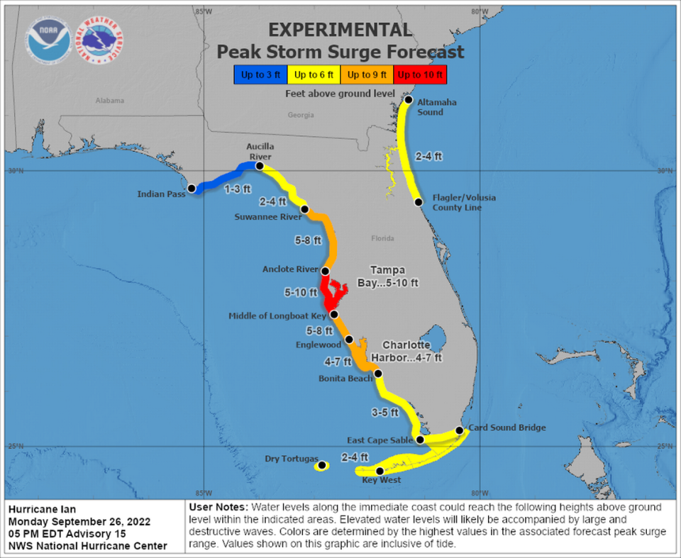
Hillsborough County officials said Monday they expect to evacuate over 300,000 people from the Tampa Bay area after the National Hurricane Center predicted Hurricane Ian could generate five to 10 feet of storm surge.
The massive movement — roughly one of every five people in the county — comes for a reason: Coastal geography makes Tampa Bay particularly vulnerable to storm surge flooding, and meteorologists worry Ian may be especially adept at piling water into the bay.
Beaches off Tampa and along much of Gulf Coast slope gradually into a long, shallow stretch of seafloor known as the West Florida Shelf. When hurricanes whirl along Florida’s west coast, they stir up water from the Gulf of Mexico and push it inland. The West Florida Shelf creates a ramp that forces water to pile up before crashing into Tampa Bay, which funnels the water in toward not only Tampa but smaller surrounding communities like Town ‘N’ Country and Oldsmar.
The forecast track of Ian shifted south of Tampa, a small but significant change that could reduce the extreme flooding risks the area — but raise if for coastal communities to the south from Sarasota down to Fort Myers and Cape Coral. Where Ian finally comes ashore will make a huge difference.
The region has “perhaps some of the highest vulnerability in the country” to storm surge, acting National Hurricane Center Director Jamie Rhome said at a Sunday press conference.
“I’m telling you it doesn’t take an onshore or a direct hit from a hurricane to pile up the water,” he said. “We could see a significant amount of storm surge on the west coast of Florida even if the storm stays offshore.”
A wave of development in vulnerable coastal areas and the impacts of sea rise have heightened the concerns for the region. Tampa Bay has more property at risk of storm surge flooding than any other area of Florida, according to a January analysis from the Tampa Bay Times’ Zachary Sampson and Langston Taylor. Pinellas County alone has $30 billion worth of property that could flood in a Category 1 storm — the largest liability in the state. The most vulnerable parts of Tampa Bay, including stretches of Pinellas and Hillsborough counties, have more than 5,000 properties that could flood in a Category 1 storm.
Local sea levels also have risen about eight inches since 1946, according to the Tampa Bay Climate Science Advisory Panel, giving storm surge floods a higher baseline to start from when they inundate the coasts. Flood risks will only increase in the coming decades: The panel predicted in 2019 that Tampa Bay would see between 1.9 and 8.5 feet of sea level rise by 2100.
The connection between sea level rise and storm surge is one of the impacts of climate change on hurricanes that scientists are most confident about, while questions still remain about how a warmer world could impact the severity, number and location of tropical storms and hurricanes.
READ NEXT: Hurricane season 2021 is over. Could future ones see more storms rapidly intensify?
Storm surge remains somewhat difficult to predict, though the National Hurricane Center is continuing to refine its models. Much can depend on the angle from which a hurricane approaches, wind speed direction, tides and other factors. Ian will be the latest test.
On Tuesday, the National Hurricane Center revised its forecast to bring Ian shore faster - but a stall off the coast that was predicted earlier could still happen. That would add to the coastal flooding risks.
“A slow-moving storm can pile water into the bay for an extended period of time and cause significant flooding issues that people may not have seen previously in faster moving storms,” said Jonathan Porter, the chief meteorologist for Accuweather. He said sea rise could play a role in Ian. But it also may be difficult to pinpoint the specific impact.
It’s king tide season again. Here’s when (and where) Miami could see high tide flooding
“Higher sea levels in the future can create a more substantial baseline for storm tide to add onto, potentially resulting in greater levels of flooding and expanded areas of flooding during hurricanes and tropical storms,” Porter said.
But when asked about the impact of sea level rise on storm surge at a Monday press conference, Rhome, the National Hurricane Center head, said this was not the time to discuss it. “There’s ample time after the season to discuss climate change. I want to focus on the here and now,” he said.
This climate report is funded in part by a collaboration of private donors, Florida International University and the Knight Foundation. The Miami Herald retains editorial control of all content.
Miami Herald staff writer Alex Harris contributed to this report.

