
 Yahoo Movies
 California’s water supply is controlled by this covert room. Can it adjust to climate extremes?
From an unmarked Sacramento office building next to a Costco, a handful of dispatchers in front of computer screens move enough water to quench the thirst of 27 million Californians without leaving their chairs.
A few clicks open the gates for nearly two dozen dams and ship entire cities worth of water through 700 miles of canals. With a mark on a spreadsheet, they heave it up 1,926 feet and consume more energy than anything else in the state.
Just months ago, three of the driest years on record sapped the world’s largest water utility into a state of anemia. Now a historic snowpack is gushing off the Sierra and the Operations Control Center of the California State Water Project is moving a deluge.
In fact, it’s moving too much water.
“This year there’s more water than places we can put it in,” said Behzad Soltanzadeh, division of operations manager for the project, who has suddenly found himself very busy.
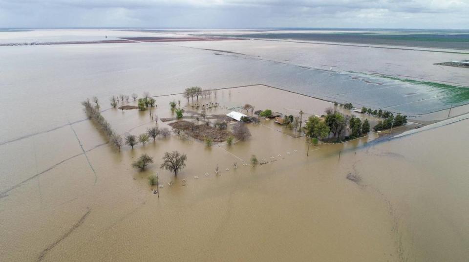
That’s even after the Department of Water Resources gifted more supplies to larger agencies and diverted record-high flows on the Kern River to slow flooding in Tulare Lake, which resurfaced this spring after it was drained nearly a century ago for agriculture.
Amid all this excess, the promise of future drought has many in California thinking about how to capture it. But scientists and officials warn the state’s aging water management system is ill prepared for the oscillating climate extremes we now come to expect.
It’s go time for water traffic control
The next time you’re sitting in a restaurant in Los Angeles, consider the water in your glass.
It likely came from the granite peaks of the northern Sierra Nevada some 500 miles away before melting into the Feather River. The country’s tallest dam held it in Lake Oroville for a while, then let it course through the Sacramento-San Joaquin Delta.
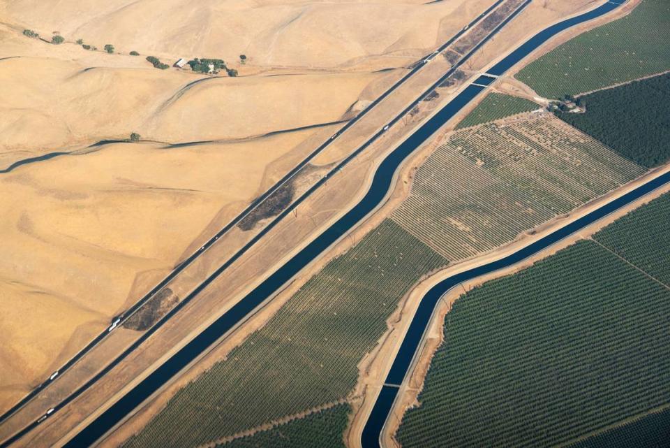
After giant pumps pushed it south, it traveled along the California Aqueduct, the world’s largest man-made river. Finally, fourteen five-story high pumps with 80,000-horsepower gave it the ‘Big Lift’ up the Tehachapi mountains, the highest single water lift in the world, and into the San Fernando Valley.
From snowmelt to tap, the dispatchers working 24/7 in the State Water Project’s control room deliver it to you in about 9 days.
They put in 12-hour shifts behind locked doors, tucked inside a discreet joint federal and state facility with four layers of security. No photographs are allowed, and only a select few members of the public are granted entry with a chaperone.
One of those privileged visitors was Joan Didion, the celebrated California writer who, in her 1979 book The White Album, described the project as a “three-billion-dollar hydraulic toy” when observed from this room.
Back then, the control room buzzed with alarms and hummed with teletypes printing out reports on Delta salinity and tides. Today, the room is mostly silent, except for the soft clacking of keyboards and the muted sound of the Weather Channel.
The room’s tightly regulated communication systems, which power the remote controls, have undergone several upgrades over the past 50 years. But apart from routine maintenance, very little has changed about the project’s mechanics.
A massive map of the project, with lights that once flashed wherever water went, has been retired. In its place, a simple white line symbolizing the aqueduct cuts across two hulking black screens in each corner of the room.
Water data on the screens are measured either in acre-feet, the amount of water it takes to flood an acre of land one foot deep, or cubic feet per second, the time it takes to move a basketball full of water.
White squares mark 20 pumping stations and flickering data points measure isolated pools of water in the project’s 21 reservoirs. Below, small red boxes show that a pump is operating and green means out of commission.
The room’s silence is deceptive. Record rain this winter and a 300% above average snowpack led DWR to promise 100% of requested supplies to water districts and agencies around the state for the first time in 17 years.
Every day this season, dispatchers will orchestrate a statewide dance of supply and demand. The project’s five field divisions send requests each morning for how much water is needed by contractors. A schedule is made, and the dam gates open accordingly.
Five hydroelectric power plants generate 6,500 GWh, so dispatchers are in constant communication with California’s power grid operator as they manage daily flow. Whether the water is generating power or consuming it, levels can’t be too low or too high.
Subsidence is a serious long term issue, as the ground literally sinks underneath its concrete from chronic agricultural groundwater overpumping.
But right now, the major challenge is that there’s simply more water coming off the mountains than places to put it. And with memories of punishing drought still fresh, water managers desperately want to hold onto the excess.
“I wish we had another reservoir,” Soltanzadeh said, referring to the Sites Reservoir project that cleared a major water rights hurdle this week but faces vehement opposition from environmental advocates.
“We’d be able to store more water and be prepared for the next extreme drought event better than if we didn’t have it.”
A new kind of water infrastructure?
The State Water Project and its control room are often credited to California Gov. Pat Brown.
He said its purpose was to “correct an accident of people and geography” — to protect against floods in the north and bring it to the more populous and arid south. Even then, California climate extremes were the norm, but Brown probably didn’t expect human-caused warming to exacerbate them.
Scientists have long anticipated faster swings between extreme wet and dry, not to mention higher likelihood of a devastating flood. Yet climate information and forecasting have only recently started to become part of water management in the state.
Just this year, reservoir managers began to consider weather forecasts in winter before releasing water from certain dams in hopes of storing more for dry months ahead. They historically released water to make room for potential storms using fixed seasonal rules.
Water managers were also over-relying on historical averages for key drought forecasts. The Department of Water Resources drastically overestimated California’s water supply during the 2021 drought, a state auditor’s office report said last week.
The department estimated runoff at more than twice the volume that actually flowed in most watersheds, the report said, recommending that climate modeling avoid relying on historical averages and factor in the consequences of climate change instead.
In response, DWR director Karla Nemeth said that year’s drought conditions “were extreme and outside the bounds of historical experience,” adding that department staff “immediately embraced” the error as an opportunity to “learn, adjust, and improve.”
Beyond more accurate forecasts, scientists and managers are asking how California water infrastructure can become more nimble during wet years in anticipation of the dry, and vice versa.
Andrew Schwartz, the State Water Project’s climate action advisor, said the department considers the long-debated Delta Conveyance Project as a way to increase flexibility. A recent executive order from Gov. Gavin Newsom could expedite it, to the outcry of environmental advocates.
Historically, water conveyance infrastructure devastated wildlife including fish native populations relied upon by indigenous Californians. For these and other reasons, UCLA climate scientist Daniel Swain said more concrete is not the answer.
Swain said we need a new paradigm where water is managed for dry and wet extremes at the same time. That could include bolstering existing dams and levees in some places for safety, or bulldozing them in others and re-building them further away to expand floodplains and help store water underground.
Instead of reacting to short-term emergencies such as in Tulare Lake, he added, officials should make long-term plans to enhance cooperation of state and federal water projects and take more proactive measures to restore depleted groundwater basins.
“This infrastructure should be different from what we’re used to building. It’s not new big dams, or higher levees. It’s actually almost the opposite,” Swain said. “It’s building ways to move waters that can spread out in the right place at the right times.”
Back inside the control room in the 1970s, Joan Didion kept thinking about the last line of a Karl Shapiro poem. Her “obsessive interest” in California water was not about politics, she said, but in the waterworks themselves.
The writer’s impulse was to take the reins from the dispatchers and control the flow. Using the siphons and pumps, forebays and afterbays, weirs and drains, she could put water wherever she wanted — or felt that it needed to go.
“It is raining in California,” the poem went.
Cleaning the heavy oranges on the bough, filling the gardens till the gardens flow.
Shining the olives, tiling the gleaming tile, waxing the dark camellia leaves more green.
Flooding the daylong valleys like the Nile.”

