
 Yahoo Movies
 Snow, frosts, hail and sleet forecast for the start of winter
The start of winter is set to bring snow, frosts, hail and sleet across the UK with weather warnings issued in some areas.
Tuesday is the first official day of meteorological winter, and with it has come colder conditions and forecasts of snow and icy conditions in some places.
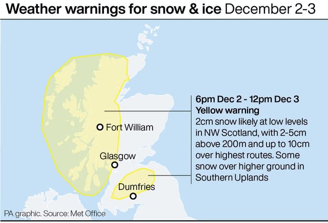
The Met Office has issued yellow weather warnings for snow and ice in Scotland for Wednesday and Thursday as it is set to get “a taste of winter,” according to meteorologist Bonnie Diamond.
People in Central, Tayside and Fife, Highlands and Eilean Siar, Lothian Borders, Strathclyde and south-west Scotland can expect frequent showers to turn to snow along with possible sleet and hail at the coastline.
Scots in the north west could see 2cm of snow by Thursday morning with 2-5cm above 200m and up to 10cm over some of the highest routes.
Some snow could also reach the Southern Uplands, according to the weather warning.
Some wintry scenes could see snow showers and icy stretches, which are likely to bring some travel disruption.
The Met Office described Tuesday as “a fine start” to December for many people and said that southern and eastern areas would continue to see plenty of afternoon sunshine.
Thicker cloud is expected further north-west across the UK which will bring some light rain at times in the north and north west of Scotland.
Across the UK, temperatures reached 7-9C (45-49F) on Tuesday making it a “crisp, clear, chilly winter’s day” for most on December 1, according to Ms Diamond.
Temperatures are set to reach 6-8C (43-46F) on Wednesday and it will feel much colder at 4-8C (39-46F) a day later thanks to some stronger winds in most places, she added.
The Met Office reports that a band of cloud and rain is set to move south-east on Wednesday and that it will be colder with sunny intervals, heavy showers and strong winds in the north.
Today is the first day of meteorological #winter and some of us have woken up to a beautiful sunrise to begin #December. Please keep sending us your photos using #loveukweather 📷☀️@ar_ar888 @CarlaSears @Liam_Ball92 @LukeMiall pic.twitter.com/e4W5udO5nN
— Met Office (@metoffice) December 1, 2020
Colder, unsettled conditions are expected to spread to the entire UK on Thursday with frequent showers, areas of heavy rain and some hill snow, the Met Office said.
There is also the chance of some snow to lower levels later in the week although away from hills it is currently uncertain exactly where snow will fall.
Frosts may form in the clear periods between bands of wintry showers and these could be sharp or even severe in prolonged clear conditions in north-western parts of the UK.
In London, cloud and light rain are forecast throughout the week while in Cardiff, heavy rain on Thursday is expected to give way to sunny spells over the weekend.
Belfast will see cloud and light rain throughout the week reaching highs of 8C (46F) on Saturday.
