
 Yahoo Movies
 What is Saharan dust? When is it coming to Florida? And what’s good and bad about it?
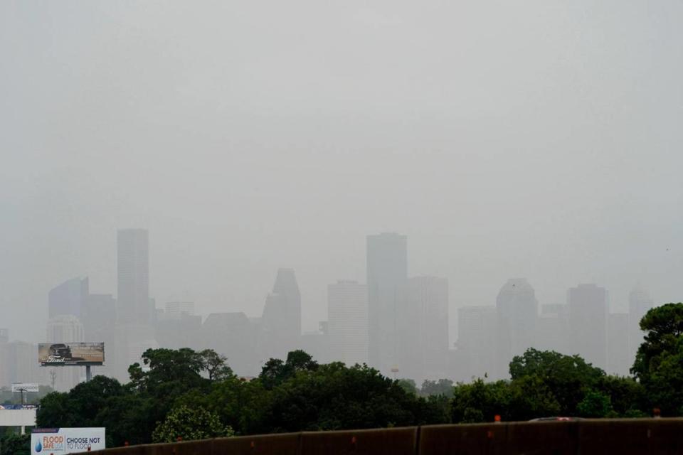
Florida is about to get a good dusting — and it’s got a name.
Saharan dust.
You may have heard reports that a huge plume of the stuff is on its 5,000-mile journey from Africa to our neighborhoods. Some of you are pulling your professional cameras out of storage. Some have their inhalers close by.
Still others are asking: What is Saharan dust? Is this a good thing? Should I run to Publix for supplies?
Here are some answers.
What is Saharan dust?
Saharan dust, also referred to as the Saharan Air Layer by the National Oceanic and Atmospheric Administration, is “a mass of very dry, dusty air that forms over the Sahara Desert during the late spring, summer, and early fall.”
This dust cloud, so to speak, whipped up from Africa’s Sahara Desert — a 3.6-million-square-mile hot desert, the largest in the world — moves over the tropical North Atlantic Ocean every three to five days, according to NOAA.
The Saharan dust layer is about 2 to 2.5 miles thick and about a mile above the earth’s surface.
When is it Saharan dust season?
SAHARAN DUST COMING! The first Saharan dust plume of the season moved off of Africa and is headed toward Florida. While many enjoy the vibrant sunrises and sunsets it brings, allergies can be agitated by the dust.
Here's when it will reach Florida: https://t.co/QR1UDQ17ln— FOX 35 Orlando (@fox35orlando) May 20, 2022
Saharan dust doesn’t have a named season, like the wet season or hurricane season or lovebug season, but its activity has prevalent periods.
The activity usually ramps up in mid-June, peaks from late June to mid-August, and begins to rapidly subside after mid-August, NOAA explains.
During peak periods, these outbreaks emerge from the coast of Africa every three to five days and can travel more than 5,000 miles to the west carried by trade winds to places including Florida, the Caribbean, Texas, Kansas and Central America and cover vast areas of the Atlantic Ocean.
An arrival of Saharan dust is forecast for Florida this weekend.
Happy Friday! Saharan dust seen over @NASAKennedy. Have a great day, the last Friday for many schools here. #sunrise #spacecoastskies #flwx #stormhour #FridayFeeling #SaharanDust #VAB pic.twitter.com/PJ1fh2tvJD
— Space Coast Skies (@SpaceCoastSkies) May 20, 2022
What’s good about Saharan dust?
Do you like hurricanes? No? Well, hurricanes don’t like the Saharan Air Layer, either. And that’s a good thing for us.
Saharan dust suppresses tropical cyclone formation and intensification, according to the National Weather Service and NOAA.
Why? A combination of factors, meteorologists explain.
▪ Saharan dust is an extremely dry, dusty air mass, containing about 50% less moisture than the typical tropical atmosphere, the National Hurricane Center notes. “This extremely dry air can weaken a tropical cyclone or tropical disturbance by promoting downdrafts around the storm.”
▪ Strong winds in the Saharan dust layer of about 25-55 mph, referred to as an “African easterly jet” by forecasters, substantially increase the vertical wind shear in and around the storm environment. This “jet” of big winds at a height of 6,500 to 14,500 feet can cause a tilting of the tropical cyclone vortex and can disrupt the storm’s internal heat engine, according to the weather service. Think of it like the proverbial monkey wrench left in your car’s engine by a careless mechanic. The “engine” is going to react negatively eventually.
▪ The warm temperatures in the Saharan dust layer riding above relatively cooler, denser air, stabilizes the atmosphere, which can suppress the formation of clouds, meteorologists say.
Beautiful sunsets

Gorgeous sunsets are another thing that’s good about Saharan dust. Here’s where you’ll want to get out your good camera or a smartphone with the highest pixels possible.
The reason has to do with how light from the sun makes its way to Earth and how its wavelengths interact with the dust cloud. The filtering of shorter wavelengths of blue, green and purple during sunset and the longer wavelengths of orange, pink and red that amplify at sunset get enhanced by the dust in the upper atmosphere, meteorologists explain.
This amplification, like a filter on your camera, enhances the colors of the sunset to make them appear deeper and richer after the wavelengths’ interaction with the dust particles.
The result? Vibrant sunsets.
What’s bad about Saharan dust?
Saharan dust can irritate people’s eyes, ears, noses and throats due to fine particles of silica and other minerals in the dust that can get into our lung tissue, according to NASA.
If you have allergies or health issues like asthma or COPD you may want to stay indoors during waves of Saharan dust, which can last in the area for a few days. You can also consider wearing a face mask, much like we’ve grown accustomed during the COVID-19 pandemic, to filter out some of the particles, the American Lung Association suggests.

