
 Yahoo Movies
 Highway 1 to Hope reopens as rains ease in southern B.C., but flood warnings remain in place
The latest:
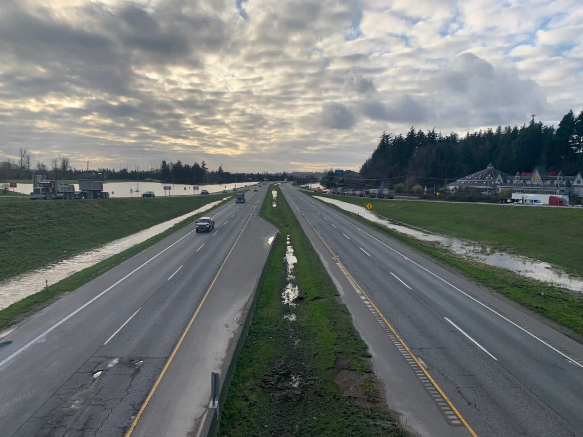
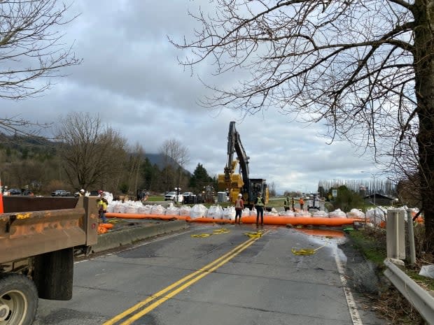
Highway 1 between the Lower Mainland and Hope, B.C., has reopened as of Thursday afternoon.
British Columbia is set to begin rebuilding from extensive flooding and mudslides after the last of three major storms eased off on Wednesday evening, but flood warnings remain in place for large parts of the province.
The stretch of the Trans-Canada Highway connecting the Lower Mainland to Hope, B.C., has reopened as of Thursday afternoon.
"I know this is very welcome news to many people in the region," Transportation Minister Rob Fleming said during a news conference.
Further east, from Hope to Popkum, is also open, though with restricted flow of traffic near Bridal Falls.
"We're not back to driving normal yet," Fleming said, as he advised residents to follow fuel restrictions.
"If your travel is not necessary, please don't be out there just yet."
Public Safety Minister Mike Farnworth is reminding those who do need to be on the roads to have their winter tires on, and to keep an emergency kit in their car.
Communities battered by floods, including many in the Fraser Valley and the Nicola Valley east of Vancouver, remain under flood warning because of high river levels and elevated temperatures causing snow melt.
A flood watch means river levels are rising and may exceed their banks and flood adjacent areas. A flood warning means river levels have exceeded or will exceed their banks, and nearby areas will flood as a result.
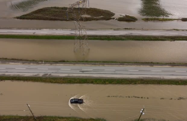
Numerous highways also remain closed throughout the province, including Highway 99 between Lillooet and Pemberton because of a mudslide, as well as Highway 3 east of Princeton.
A mudslide on Canadian Pacific train tracks also led to the cancellation Wednesday evening of West Coast Express commuter trains between Metro Vancouver and the Fraser Valley, with further closures on Thursday morning because of a mudslide on the tracks.
Service resumed Thursday afternoon with delays. Trains were delayed arriving into Port Haney and Mission City Stations because they had to reduce their speeds going through the mudslide area.
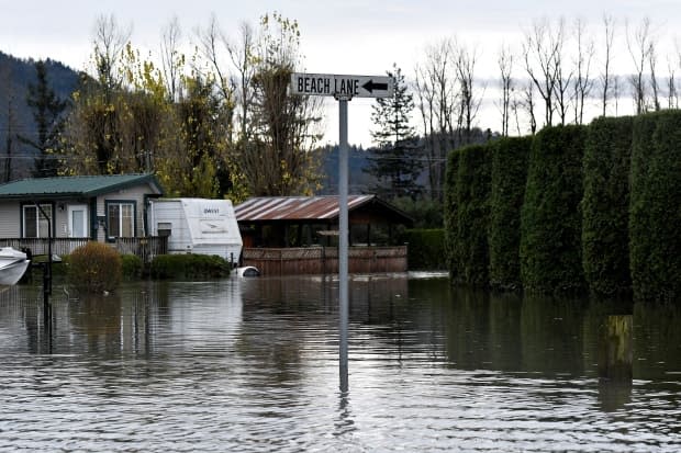
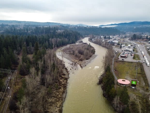
In Abbotsford, there are concerns that snow melt from Mt. Baker in Washington state could lead to more floodwater flowing into the Fraser Valley from across the U.S. border.
The storm systems that brought rain to much of southwest B.C. over the last two weeks of November also brought elevated temperatures, according to meteorologists. But temperatures are dropping, and snow is now in the forecast for the region over the next week.
Abbotsford Mayor Henry Braun said modelling showed water levels would subside toward the end of the week, but said the situation could change in minutes.
"I would like to stress that even though it may not be actively raining, there is a lot of rainwater and snow melt that is still making its way down from the mountains," he said on Wednesday.
"The situation still remains variable and we are continuing to monitor this situation very closely."
In a flood update on Thursday, Braun said the water levels in Sumas Prairie dropped seven inches in the last 24 hours, due to the Barrowtown pumping station.
"While seven inches, or 178 millimetres, is still good progress for one day, there is still a lot of water to be pumped out," he said.
The process of draining the Sumas Prairie will take another two to three weeks and those who live in the affected areas won't be able to return home until that work is complete, Braun said.
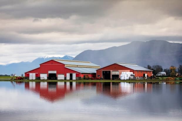
Many who lived in the Sumas Prairie are farmers. B.C. Agriculture Minister Lana Popham said at a news conference that 628,000 chickens, 420 dairy cows, 12,000 hogs, and 120 beehives were lost to the floods.
WATCH | Higher temperatures from storms bring risk of snow melt:
Daily access permitted for some Merritt residents
Meanwhile, the City of Merritt is moving forward with their "Return Home Plan," as city officials say flood mitigation efforts were successful during consecutive rain storms that moved over southwestern B.C. this week.
Residents in the Phase 4 boundary are allowed daily access to their property from 7 a.m. to 7 p.m. starting Thursday.
The area still remains under a "do not consume" water advisory and an evacuation order — meaning residents must be ready to leave their homes at a moment's notice.
Phase 3 residents will be able to return to their homes on Sunday if a pending water sample test comes back clean, which means free of hydrocarbons and contamination.
The results will be released on Saturday.
Interior Health, the local health authority, also announced that regular operations at the Nicola Valley Hospital in the town would resume. The hospital's emergency department is set to resume 24-hour operations on Friday.
New mudslides lead to highway closures
After numerous temporary highway reopenings, closures on Wednesday meant Metro Vancouver was once again effectively isolated from the rest of the province.
A fresh mudslide on Highway 99, in the Sea to Sky region, led to a closure between Pemberton and Lillooet. The stretch earlier saw a mudslide that left four people dead and one missing during the mid-November storm.
Highway 3 from Hope to Princeton is open for essential travel only. However, on Wednesday flooding east of Princeton forced a closure between Taylor Way and Old Hedley Road. There is no detour for commercial vehicles, but light vehicles may navigate around the closure using Old Hedley Road.
Extensive rebuilding on washed-out highways, including the Coquihalla (Highway 5), is expected to take a long time, further constraining the supply chain throughout the province.
WATCH | Supply chain snarled throughout B.C.:
Flood forecasting centre understaffed: report
The River Forecast Centre, which issues flood warnings for the whole province, was found to be understaffed in a report from the Canadian Centre for Policy Alternatives (CCPA) on Wednesday.
Ben Parfitt, a resource policy analyst with the CCPA, said the centre in its current form is ill-equipped to anticipate and respond to flooding events.
Parfitt said understaffing could lead to an inability to effectively communicate timely warnings — something he said happened in B.C. during these past two weeks.
Farnworth defended the institute, saying the centre "does an amazing job and we have extraordinary individuals that do amazing work."
However, he acknowledged that the government would be reviewing its response to the flooding emergency going forward.

