
 Yahoo Movies
 Monsoonal moisture, heavy rain and thunderstorms are coming to Idaho. Here’s what to expect
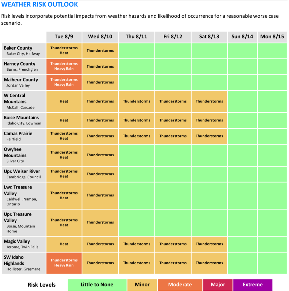
The National Weather Service in Boise expects deep monsoonal moisture to spread over southeast Oregon and southwest Idaho in the next few days, bringing much-needed rain to the arid region.
Up to a quarter of an inch could fall in regions south and southwest of Boise, such as over Idaho’s Owyhee Mountains and Oregon’s Malheur and Harney Counties, Weather Service meteorologist Sophia Adams told the Idaho Statesman.
Adams said that the highest chance of localized flooding will come if storms “train,” or repeatedly form in a row and track over the same area.
Boise’s main threat of storms will arrive on Wednesday, Adams said, with the chance of an isolated thunderstorm the most likely source of rain. As of Tuesday morning, the Weather Service in Boise forecasts a 20% chance of thunderstorms on Tuesday night and 30% of rain showers Tuesday night into Wednesday.
“We could see an isolated storm in the Treasure Valley with heavier rainfall, but we’re more concerned about those heavier rainfall totals near the Owyhee Mountains,” Adams said.
The rain comes as a result of a monsoon in the desert southwest, which typically happens once a year in North America. Warm air from the Gulf of California and Gulf of Mexico meet over mountains in Mexico before traveling north with moisture-heavy clouds.
Low-pressure systems in the upper atmosphere push the storm northward, a deviation from the norm: weather systems typically follow the jet stream and move from west to east.
“Right now, we see a pretty big upper-level low (pressure system) off the west coast of the United States, and we have a fairly large range of high pressure over the western plains, like Wyoming and Colorado,” Adams said. “That kind of gives us a little bit of a gateway of southerly flow for that moisture from the southwest.”
Although the main threat of heavy rain will persist south of Boise, areas of the Boise Mountains around McCall, Cascade and Idaho City could see the threat of thunderstorms last through Saturday.
The potential for storms to last into the weekend north of Boise — which should be in the clear come Thursday — is because rain clouds form more easily over mountainous regions as the air rapidly cools and rises up the high summits.

