Yahoo Movies
 Midlands should prepare for tropical storm winds, potential floods Friday. Here’s the latest forecast
The Midlands area is under a tropical storm warning, with heavy rain and wind gusts up to 60 mph expected to arrive Friday.
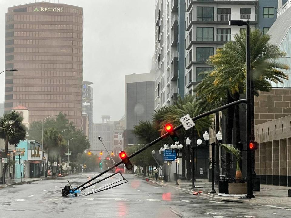
Hurricane Ian, which made landfall on Florida’s southwestern coast as a Category 4 hurricane Wednesday afternoon before being downgraded to a tropical storm Thursday morning, returned to hurricane strength Thursday afternoon. It is expected to make landfall on South Carolina’s coast Friday afternoon.
A tropical storm warning means tropical storm-force winds are expected in the area within the next 36 hours, as opposed to a watch, which indicates severe weather is a possibility, but not currently happening.
Tropical storm force wind gusts between 50 and 60 mph may arrive in Columbia Friday morning, National Weather Service meteorologists said during a 6 p.m. Thursday briefing.
The greatest storm threats in the Midlands will be heavy rain and potential flash floods, according to the National Weather Service.
A portion of the Midlands, including Richland and Lexington counties, are under a flood watch from 5 a.m. Friday until 8 a.m. Saturday.

Rain is expected to arrive in the Columbia area late Thursday, with up to 6 inches predicted for the Columbia area Friday. Gusty to tropical storm force winds are likely to die down Friday night, and conditions may significantly improve by Saturday, according to the Thursday evening briefing.
The forecast trends have grown “more concerning” since earlier this week, National Weather Service meteorologist John Quagliariello said during a 4 p.m. briefing with Gov. Henry McMaster Thursday.
Quagliariello said Ian is expected to make landfall Friday along the central and northern portion of the South Carolina coast, then shift northward into the state through Friday night.
“This is not just a coastal event,” South Carolina Emergency Management Division Director Kim Stenson said during that briefing. “We expect this storm to impact all of South Carolina over the next several days.”
Impacts may be less severe in the Central Savannah River Area as the storm track shifts eastward, NWS meteorologists said Thursday as of 6 p.m.
Strong winds in the Midlands could cause damage to buildings like sheds and mobile homes, as well as lead to snapped or uprooted trees, the National Weather Service warns. Debris could also block roadways.
Power outages are also being anticipated, as the wind may down power lines or otherwise disrupt service. If a power line is downed, it could still contain electrical currents and residents should avoid them, emergency management officials warn.
Tornadoes are unlikely, according to forecasters. The risk increases slightly for the far-eastern portion of the Midlands, according to the National Weather Service.
Ian is expected to make landfall as a Category 1 hurricane on South Carolina’s southern coast around 2 p.m. Friday.
By the time the storm reaches Charlotte early Saturday, it is expected to be downgraded to a tropical depression, a storm with winds at 38 mph or below, according to forecast models from Thursday evening.
McMaster declared a state of emergency in South Carolina Wednesday, enabling state agencies to move more freely to address damage and safety concerns.
Most Columbia-area school districts decided to close buildings and hold classes online Friday.
The University of South Carolina will close its Columbia campus Friday. Virtual and in-person classes have been canceled for Friday as well.
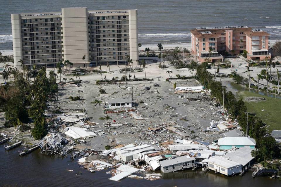
Ian decimated portions of Florida’s gulf coast Wednesday when it made landfall as a Category 4 hurricane, verging on Category 5 strength.
Media reports on deaths in Florida from the hurricane varied Thursday night, ranging between five and nine reported deaths. Coast Guard helicopters worked to rescue residents stranded by floods in Florida Wednesday and Thursday. As of 2 p.m. Thursday, 28 people had been rescued by the Coast Guard, according to ABC News. Millions were without power in Florida Thursday morning.
Ian is the fourth Atlantic hurricane of the season, and the first to make landfall in the continental U.S.