
 Yahoo Movies
 Tornado Touches Down East Of Downtown Los Angeles As Video Surfaces Of Possible Second Twister Near Santa Barbara – Update
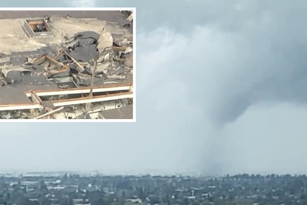
UPDATED with the latest: The morning after the National Weather Service issued a Tornado Warning for Northwest Los Angeles and parts of Ventura County, videos began surfacing online of a short funnel reaching down toward a swirling cloud of debris on the ground about 50 miles away. Local (and national) TV news outlets were soon all over the incident, which took place in Montebello.
NWS confirmed that the tornado — whose strength has not yet been measured — hit around 11:20 a.m. Wednesday. The storm was focused in a largely industrial district, and Montebello Fire Department officials said that city inspectors examined 17 buildings in the affected area, and 11 of them were red-tagged, or marked unsuitable for occupation. Fire authorities also said one person was injured.
More from Deadline
Video from the scene shows portions of rooftops ripped off industrial structures and debris swirling in the air.
I caught it one video. pic.twitter.com/ckIlC4LQ8h
— ⚜️ Mark ⚜️ (@fleur_de_lis13) March 22, 2023
Per KTLA5, The Verdugo Fire Communications Center said the “weather incident” was reported a few minutes before 11:30 a.m. when they responded to the 1200 block of South Vail Street.
Tornado hits south maple ave in Montebello tearing the roof off multiple buildings and destroying multiple cars pic.twitter.com/yJrbuPMccj
— Turtle (@njtehcherchian) March 22, 2023
There was no Tornado Warning in place late Wednesday morning when the powerful winds hit Montebello. The National Weather Service’s Los Angeles office, based in Oxnard, confirmed early Wednesday afternoon that it will be sending a “survey team” to Montebello to assess the damage in response to “reports of possible tornado damage.”
@KTLA @ABC7 tornado/twister in montebello pic.twitter.com/dwbxGYVdqY
— Big Rob (@TheRedRanger23) March 22, 2023
The NWS also dispatched a team to the Carpinteria area, which suffered damage Tuesday evening that could have been the result of a small tornado or landspout. That seaside hamlet is much closer to the area covered by the alert the night before.
There have been reports of possible tornado damage in Montebello. In addition to the survey team heading to Carpinteria, they will also head to Montebello this afternoon to assess the damage. Check out the PNS here: https://t.co/te8O8tBoYr#CAwx
— NWS Los Angeles (@NWSLosAngeles) March 22, 2023
ABC News posted video this afternoon from Carpenteria that looked a lot like the footage from Montebello.
National Weather Service survey teams have been dispatched to investigate damage caused by two possible tornadoes in Southern California. https://t.co/o2mN1tBKFx pic.twitter.com/Q296FCraaF
— ABC News (@ABC) March 22, 2023
Shortly after the Montebello incident, the NWS issued an alert about “a strong thunderstorm near West Covina, moving northeast at 15 mph.” The statement indicated that “this thunderstorm is capable of producing a weak tornado or strong downburst winds.” The alert covered San Dimas, Glendora, West Covina, Pomona, Azusa, Claremont, Baldwin Park, Irwindale and Duarte, most of which are just to the east of Montebello.
According to the NWS, a landspout is technically a tornado, but causes less damage than the “typical” tornado. Landspouts are narrow and have a “spinning motion that originates near the ground.” A larger “supercell tornado” is identified by its defining “rotating updraft,” which is absent in landspouts.
We've received lots of questions regarding what is a landspout vs. a tornado. A landspout IS a tornado. It usually causes less damage than a "typical" tornado. Check out this Weather-Ready Nation graphic explaining the differences of a couple different tornado types. #CAwx pic.twitter.com/d235TUXXlM
— NWS Los Angeles (@NWSLosAngeles) March 22, 2023
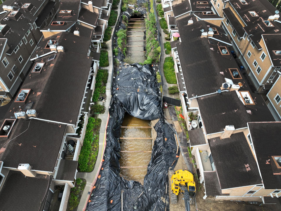
The region east of Downtown L.A. also saw a 40-foot sinkhole open up between two buildings of a La Habra condo complex after heavy rains. The sinkhole is at the location of a formerly-covered storm channel. The crater reportedly has a current of water flowing through it, which could potentially cause further collapse.
PREVIOUSLY on Tuesday: At about 8:18 p.m. Monday, the National Weather Service issued a tornado warning in parts of Los Angeles and Ventura Counties. “Take cover now,” read the alert that flashed across phones in Northwestern Malibu and Southern Ventura County. Local TV stations also issued push alerts with the warning that took many residents by surprise.
#BREAKINGNEWS: A tornado warning has been issued near the Thousand Oaks area. The warning includes Casa Conejo, Lake Sherwood, and Solromar and lasts until 8:30 p.m. https://t.co/6aIPHYpmjX
— ABC7 Eyewitness News (@ABC7) March 22, 2023
The National Weather Service in Oxnard warned of “a severe thunderstorm capable of producing a tornado was located over Point Mugu State Park, or 10 miles south of Camarillo, moving northeast at 35 mph.” The notice stated that local “radar indicated rotation” and “this dangerous storm will be near…Western Malibu around 825 PM PDT. Newbury Park around 830 PM PDT.” Under precautionary measures, the alert urged residents to “TAKE COVER NOW! Move to a basement or an interior room on the lowest floor of a sturdy building. Avoid windows. If you are outdoors, in a mobile home, or in a vehicle, move to the closest substantial shelter and protect yourself from flying debris.”
While no such extreme weather event was reported, heavy rain, lightning and thunder certainly hit the area during the period. The tornado alert was later canceled.
Tornado Warning including Casa Conejo CA, Lake Sherwood CA and Solromar CA until 8:30 PM PDT pic.twitter.com/vySFvWTYbx
— NWS Los Angeles (@NWSLosAngeles) March 22, 2023
The very rare L.A.-area tornado alert is just the latest in a string of unusual, weather-related news of late. In the hours before the tornado warning, the NWS cautioned residents about waterspouts, hail and “landspouts.”
A special weather statement has been issued for Los Angeles CA, Long Beach CA and Glendale CA until 5:00 PM PDT pic.twitter.com/Zyt3GNgpkt
— NWS Los Angeles (@NWSLosAngeles) March 21, 2023
The National Weather Service has been issuing Special Weather Statements highlighting the potential of "landspouts" this afternoon across Southern California. A landspout is a type of tornado. Here are some tornado safety tips from earlier:https://t.co/20PRPIivEe@IlyaNeyman pic.twitter.com/v6ArM9Zb6c
— KCAL News (@kcalnews) March 21, 2023
Earlier in the day, Magic Mountain Truck Road near Six Flags Magic Mountain recorded wind gusts to 102 mph, equivalent to Cat. 2 Hurricane strength.
Several weeks ago there was, of course, rare snow in the region, with flurries seen at very low elevations, including a dusting at Disneyland.
And then there is the near-constant stream of storms across the region in the past few months dumping nearly twice its average annual rainfall on the region.
City News Service contributed to this report.
Best of Deadline
2023 Awards Season Calendar - Dates For The Oscars, Festivals, Emmys & More
2022 The Year In Photos: Courtrooms, Kanye, Twitter, Tom Cruise & Zendaya
The Queen Onscreen: 15 Actresses (And Actors) Who've Played Elizabeth II In Film And On TV
Sign up for Deadline's Newsletter. For the latest news, follow us on Facebook, Twitter, and Instagram.

