
 Yahoo Movies
 Rain, flooding, evacuations, road closures: Sunday was a record-setting day in Sacramento region
A steady stream of rain was expected to continue through Sunday night, turning roads into treacherous terrain as the likelihood of fallen tree limbs and flooding increases.
The Sacramento area as well as the Sierra Nevada foothills to the east are being walloped by heavy precipitation and strong winds, the result of a powerful “bomb cyclone” storm raking its way across Northern California.
The storm, fueled by an atmospheric river, is classified as a Category 5, according to the California Department of Water Resources. Much like tornadoes and hurricanes, atmospheric river storms are categorized on a sliding scale of intensity with Category 5 at the top, described as “primarily hazardous.”
As much as 5 to 7 inches of rain was expected by day’s end in Sacramento and up to 2 feet of snow in the Sierra. That means Sunday could challenge the all-time record for the rainiest day in Sacramento history. The current record-holder is April 20, 1880, when 5.28 inches fell in a 24-hour period. As of 9 p.m., the total for the day was a mere .39 inches off that mark.
Late Sunday evening, Sacramento Office of Emergency Management’s automated notification system was calling residents to warn of localized flooding due to heavy rainfall. The message was also advising that people avoid driving until 4 a.m. Monday.
This came as forecasters had extended a flood advisory from Stockton to Chico, including Sacramento, through noon Monday.
Here Sunday’s updates from The Bee’s team of journalists:
The Flood Advisory has been extended until noon Monday as the heavy rainfall continues. Additional rain will result in areas of roadway flooding and continued flooding of small creeks. Never drive through flooded streets! #cawx pic.twitter.com/GeR5hLDtKi
— NWS Sacramento (@NWSSacramento) October 25, 2021
Lots of rain on the radar this morning. That won't be changing, heavy rain and strong winds are expected for today. Debris flows possible on recent burn scars and roadway flooding will be likely. #CAwx pic.twitter.com/EzddtRTzC4
— NWS Sacramento (@NWSSacramento) October 24, 2021
Did you know that Atmospheric Rivers have categories like Tornados and Hurricanes? The Atmospheric River expected to impact Northern California on Oct 24 is a Category 5 which is primarily hazardous, #AreYouPrepared? More on how to prepare for flood here: https://t.co/iOyTvP3ZDD pic.twitter.com/X5ck9HgR0X
— CA - DWR (@CA_DWR) October 21, 2021
National Weather Service meteorologist Anna Wanless said flash flood warnings were being issued for the Dixie and Caldor fire burn scars — the areas wiped clean by two of the most destructive wildfires of the 2021 fire season. Mudslides could occur, of the sort that killed more than 20 people in Southern California in January 2018 after devastating wildfires in late 2017.
“We are very concerned about debris flows in the burn scars,” Wanless said.
11:30 p.m.: A new record for rain in Sacramento
The one-day, all-time record for rainfall in Sacramento bubbled over in the final minutes of Sunday.
At 11 p.m., the National Weather Service’s official rain gauge for the city reached 5.28 inches, meeting the previous historic mark set on April 20, 1880. It was only a matter of minutes amid steady rain that the record fell.
The automated gauge read 5.36 inches in its 11:45 p.m. update, setting a new record and blowing well past the rest of the city’s top-10 rainmakers set over the 144 years of record-keeping, most of which were in the 3-inch range. The weather service confirmed that the total was showing a new record — by 11:30 p.m., the value had risen to 5.35.
Meteorologists at the weather service’s Sacramento office were expected to provide the official update once midnight passed and the data was reviewed.
At around 8 p.m., as Sacramento topped 4.84 inches, weather fanatics kept a close eye on the readouts from SMTC1, the identifier for the automated gauge.
“It’s going to be close,” NWS meteorologist Robert Baruffaldi said a few hours before the mark was toppled. “We got three more hours, it’s certainly very doable to beat that record. ... We’re getting a quarter of our rainfall (in our water year) in one day.”
The 30-year average for the water year, which started Oct. 1, is calculated to an average of 19.20 inches.
“When you think of it in those terms, it’s pretty nuts,” he said.
Through 8 pm, the rain continues and the Sacramento (City) precipitation total so far today is 4.84 inches. This now places us solidly in 2nd place for the all-time record daily rainfall since record keeping began back in 1877! Stay tuned for updates and stay safe. #cawx pic.twitter.com/BLsaMis2Tt
— NWS Sacramento (@NWSSacramento) October 25, 2021
The official rain gauge, which was stationed for decades at the old downtown Post Office at 801 I St. before being housed near Sacramento State, will likely see more rain through the night as the storm, fueled by an atmospheric river, continue to pummel Northern California.
—DANIEL HUNT
10:32 p.m.: Homeless evacuated after sump pump loses power
Several homeless residents in North Sacramento were moved to higher ground late Sunday after a power outage caused sump pumps to fail.
The Sacramento Fire Department said in a social-media post that crews were assisting an unknown number of homeless residents just north of Interstate 80 along Pell Drive at Pell Circle in the Pell/Main Industrial Park. That area is next door to the Glenwood Meadows section of the city.
Firefighters said water at waist-deep levels after a power outage caused pumps draining runoff to fail.
—DANIEL HUNT
9:25 p.m.: Rock slide on Highway 50, flooding on Highway 99
Flooding and debris flows from the rain continue to wreak havoc on area roadways from the Valley floor to the high Sierra.
Just after 9 p.m., Caltrans issued back-to-back advisories for Highway 99 in the Sacramento area and Highway 50 at Echo Summit.
Flooding was the main issue in Sacramento as Highway 99 between Sutterville Road and 4th Avenue saw significant delays due to lane closures. Both directions saw lane closures amid heavy traffic, according to Caltrans cameras.
In the Sierra, authorities are limiting traffic on Highway 50 at the mountain pass with one-way controls due to boulders in the westbound lane. Caltrans said in a 10 p.m. update that the rocks would need to be blasted overnight.
—DANIEL HUNT
8:15 p.m.: City of Sacramento offering sandbags
Officials with the Sacramento Department of Utilities announced Sunday night that two corporation yards would be open through he night to fill sandbags for city residents.
The yards are at 918 Del Paso Road in the North Natomas area and at 5730 24th St. near Executive Airport.
The areas are self-serve — bring your own shovel.
—DANIEL HUNT
7 p.m.: First local evacuation orders issued
The Placer County Sheriff’s Office announced the first evacuation orders in the Sacramento region due to the storm.
Just before 7 p.m., authorities said homes south of Colfax along Hillcrest Boulevard, south from the 1500 block of Hillcrest to Spring Valley Road, as well as Spring Valley Road from Milk Ranch Road and Ben Taylor Road in the areas near the Bear River were under a mandatory evacuation.
The Sheriff’s Office said the evacuations were necessary “due to the high probability of dangerous debris flows.”
The area was the site of the River Fire in August, which destroyed 142 structures and charred more than 2,619 acres in Placer and Nevada counties.
Areas on the other side of Bear Creek in Nevada County, which also suffered damage in the fire two months ago, have been under evacuation warnings since Saturday afternoon.
—DANIEL HUNT
6 p.m.: Heaviest rain, strongest winds expected late
The most severe effects of the storm are expected between 6 p.m. and midnight, with lighter rain expected Monday and Tuesday.
Katrina Hand, a meteorologist with the National Weather Service in Sacramento, said authorities were strongly discouraging motorists from getting on the roads as the powerful storm continues to dump large amounts of rain on Northern California.
“Definitely try to stay home if you can,” Hand said. “If you have to, drive careful and be aware of your surroundings. It’s pretty messy out there.”
As of 2:30 p.m. Sunday, the Sacramento area had received 2 to 3 inches of rainfall in the past 24 hours, Hand said. When it’s all tallied, Sunday could challenge the all-time record for the rainiest day in Sacramento history. The current record-holder is April 20, 1880, when 5.28 inches fell in a 24-hour period.
Hand said the California Highway Patrol on Sunday reported flooding from small streams spilling onto roads and prompting some closures. She said heavy rain was expected to continue through late Sunday, tapering off at some point on Monday. A wind advisory for most of Northern California remained in effect through 11 p.m.
Reports of wind gusts reaching 48 to 50 mph had already been reported in the Sacramento area as of Sunday afternoon, Hand said. The strong wind was expected to reduce in speed Sunday afternoon throughout the area.
The weather service issued a winter storm warning that goes into effect at 11 p.m. Sunday and ends Monday night with slippery roads and reduced visibility expected to impact travel in the elevations above 6,000 feet.
Hand said anywhere from 6 inches to 2 feet of snow could fall in the higher elevations overnight. Travel delays were expected in the mountains; drivers who need to get on the road were urged to take it slow.
Authorities encouraged drivers to avoid travel in the mountains. Drivers could see lingering flooding, damage to trees and power lines, road closures, tire-chain requirements, according to the weather service.
—ROSALIO AHUMADA
5:15 p.m.: Downtown Sacramento power outage
Nearly 3,000 SMUD customers in downtown Sacramento were without power about 5:15 p.m., according to the Sacramento Municipal Utility District.
The power outage affected about 2,926 customers in downtown.
SMUD crews were responding to 17 outages that had 3,257 customers without power in all, including 114 in the McClellan Airport area and 95 in Sacramento’s Oak Park neighborhood.
—ROSALIO AHUMADA
5 p.m.: Arcade Creek starts flooding Winding Way
Arcade Creek near American River College officially started flooding over Winding Way just before 5 p.m. Sunday, as rain continued dumping on the Sacramento region.
The Sacramento River tributary runs alongside Winding Way in Carmichael near the college, a sharply twisting stretch of road that can prove hazardous when wet. The area of road near Walnut Avenue is prone to flooding during intense rainfall.
On Saturday, the creekbed held less than a foot of water, according to Sacramento County flood monitor data. By Sunday afternoon, it had risen to nearly 9 feet, tipping it into flood monitor stage.
As of 5 p.m., the creek was running more than 10 feet deep. Earlier in the morning, Arcade Creek was seen swollen with rainwater and slowly creeping up to the roadway as the storm bore down over Sacramento County.
The record high level of Arcade Creek at American River College is still a bit out of reach. According to county data, the creek’s record high at the college, set in January 1995, is just over 15 feet of depth.
—VINCENT MOLESKI
4:30 p.m.: Caltrans truck crash
Highway 160 in Sacramento was closed for more than an hour after a car crashed into a Caltrans sign truck about 2:40 p.m. Sunday, according to the California Highway Patrol online dispatch log.
The crash occurred on the highway near the Tribute Road onramp.
The highway had already been partially closed because of flooding when the crash occurred. CBS13 reported there were moderate injuries in the crash and major damage to multiple vehicles, but the Caltrans truck was empty when it was struck.
—ROSALIO AHUMADA
4 p.m.: Highways 99 and 50 are getting flooded
Sacramento’s freeways are starting to feel the pressure from the deluge of water and debris falling in the region.
Just before 4 p.m., Caltrans reported new incidents of flooding on Highway 99 at Mack Road and westbound Highway 50 at East Bidwell in Folsom.
“Expect delays and AVOID travel today if possible,” Caltrans said in a tweet.
Many of the electronic road signs along Sacramento’s freeways are urging motorists to watch for workers on foot clearing debris, as well as flooded areas.
At the same time, traffic was slowed on the eastbound lanes of Interstate 80 as crews responded to a truck fire with part of the truck hanging over a bridge just east of Truckee, Caltrans said. One of the eastbound lanes in Floriston was blocked but another remained open.
The CHP Truckee Area Office said there were no injuries in the truck crash in Floriston. The truck crashed into a bridge wall and caught fire, with its burning cab dangling over the bridge, the CHP said. Crews extinguished the fire, but the cleanup was expected to be extensive.
Just when you think you have seen it all at Floriston…
Sometimes there aren’t even words. It’s amazing no one got hurt!
Expect a significant slow down on I-80 eastbound at Floriston due to a truck which collided with the bridge wall and caught fire. pic.twitter.com/lyPaujlGxQ— CHP Truckee (@CHP_Truckee) October 24, 2021
4 p.m.: Truckee River flooding
Minor flooding in the Truckee River near Truckee was expected to begin shortly after 4 p.m., the National Weather Service in Reno said on Twitter. The main areas of concern were Alpine Meadows to Glenshire, there was a potential for higher rises to occur including up to moderate stage depending on rainfall and snow levels, according to the weather service.
The federal California Nevada River Forecast Center expects the Truckee River to rise to flood stage just before midnight.
—ROSALIO AHUMADA
1:55 p.m.: CHP, Caltrans urge motorists to stay off roads
“Well, this doesn’t rock!” the CHP said in an afternoon tweet as the storm continued to cause havoc on roadways in the Sierra.
Bottom line from the California Highway Patrol and Caltrans, the state transportation agency: Stay off the roads if you can.
The CHP tweeted a photo from old Highway 40, which was the only roadway to cut through the Sierra at Donner Pass before Interstate 80 was built. It showed the two-lane mountain pass riddled with rocks and rushing water.
Well this doesn’t rock!!!
We are having a ton of rocks and water come off the mountain side of old 40, (Donner Pass Rd between Truckee and Donner Summit.)
The road is now closed as it is not safe to pass due to erosion and falling debris. pic.twitter.com/mUHYOQRJPx— CHP Truckee (@CHP_Truckee) October 24, 2021
Old Highway 40, also known as Donner Pass Road, is now closed between Truckee and Donner Summit.
Highway 70 above Oroville, from Jarbo Gap to Greenville Wye, is also closed as crews work to clear multiple slides in the burn areas of the Dixie Fire. One-way traffic is also in place in the Quincy area, Caltrans said.
Other roadway closures include:
Highway 16 from Highway 20 to Rumsey Canyon in Colusa County due to mudslides.
Highway 20 in the same area. One-way controls are in place in Mendocino County as well.
On Interstate 80, eastbound trucks are being screened at Applegate in Placer County for chains; westbound trucks are getting brake checks at Nyack for slippery conditions. A wind advisory is in effect on the Yolo Causeway for high-profile vehicles.
Highway 88 requires chains in Alpine County.
On Highway 99, a high-wind advisory is in effect from the Sacramento County-San Joaquin County line to the Sacramento County-Sutter County line. Travel is not recommended for trailers, campers and big-rigs.
Highway 113 also has a wind advisory from Davis to the Yolo-Sutter County line.
Locally, roadways in the Sacramento area are seeing flooding as crews work to clear debris, including fallen tree limbs and heavy amounts of leaves.
—DANIEL HUNT
1:28 p.m.: Flood warnings for Sierra counties
The National Weather Service has issued a flood warning for the Eastern Sierra area, including locations affected by the Caldor Fire. The warning lasts until 7:15 p.m. for El Dorado, Alpine, Lassen, Plumas and Sierra counties, according to the NWS Reno office.
“Flooding is ongoing or expected to begin shortly in the warned area. Between 1 and 4 inches of rain have fallen,” the weather service said. Locations include South Lake Tahoe, Doyle, Beckwourth, Sierraville, Prosser Creek Reservoir, Pyramid Lake, Incline Village, Kings Beach, Blairsden, Squaw Valley, Graeagle, Tahoe City and Alpine Meadows.
—DANIEL HUNT
12:42 p.m.: Sandbags available in Sacramento County
Sacramento County has opened three sandbag locations in response to Sunday’s storm, according to officials at the county Department of Water Resources. The sandbags are available to county residents “who believe their property will be in danger from the heavy rains resulting in flooding.” The locations are:
Branch Center, 3847 Branch Center Road, Rancho Cordova
Orangevale Community Center, 6826 Hazel Ave.
Westside Park, 6555 W. 2nd St., Rio Linda
The county supplies the sand and bags, but residents will need to bring a shovel, and there is a 20-bag limit per visit.
Citrus Heights is also offering sandbags at 6360 Fountain Square Drive; officials there ask you bring your own shovel.
Folsom residents can pick up sandbags at 48 Natoma St., behind the Arts & Senior Center, and 9700 Oak Avenue Parkway, behind Fire Station 36.
Both cities require proof of residency to get sandbags — a driver’s license or utility bill will do.
—DANIEL HUNT
12:18 p.m.: 24-hour totals around region
The rainfall totals over the 24-hour period ending at noon Sunday were impressive in Sacramento and elsewhere.
Sacramento Executive Airport received 1.96 inches in the 24-hour period, according to the National Weather Service. The city’s official gauge, at Sacramento State, reported 1.86 inches fell in the same period.
Rainfall was even higher in the eastern suburbs with Rosemont getting 2.57 inches, Orangevale getting 2.28 inches and Foothill Farms receiving 2.24 inches of rain.
Precipitation was higher in the foothills east and north of the capital. El Dorado Hills gauge reported 5.29 inches, while the Caldor Fire area received anywhere from an inch and a half in Placerville to 1.95 inches in Strawberry. Pollock Pines had 2.57 inches and South Lake Tahoe got 1.75.
—DANIEL HUNT
11:52 a.m.: Preparation key in Arden Arcade
The roadways were lighter than usual along El Camino Avenue in the Arden Arcade section of Sacramento’s suburbs, but that didn’t mean the storm was stopping people from venturing out for necessities.
At Emigh Hardware, near Watt Avenue, business wasn’t too busy Sunday, but that’s because most people had heeded the warnings ahead of time.
“It was a little crazy yesterday, that’s for sure,” said store manager Randy Aspinall. “We had everybody trying to get prepared for the storm.”
Aspinall said once the storm hits, traffic gets a little lighter — that is until the lights go out: “Then they all come in for flashlights,” he said.
Aspinall said during this time of year, Emigh patrons are busy readying homes for the fall, buying rakes, leaf bags, gutter guards and other materials for the usual foliage drop. But throughout the week, he and his staff sensed many had heard of a big storm coming, and were stocking up on tarps, drainage accessories and other goods better suited for clearing water and debris.
“Everybody that came in was thinking about getting prepared. I would have to say they were listening or reading what was going on,” he said. “They were probably better prepared than maybe we were.
“It’s been a long time since we’ve had a really good rain. … It’s a lot.”
Down the street at the Dutch Bros. coffee drive-through, business kept on humming for drivers looking for a jolt of caffeine. And the order-takers were well prepared for anything that came their way.
The chain provides its team members with an ingenious plastic enclosure, known as Under the Weather pods, to keep them and their electronics safe from the elements.
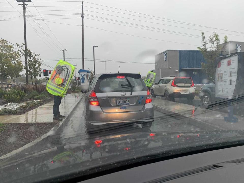
Calen Genovaga didn’t mind working in the rain with the pod: “It’s kind of cool, I kind of like it — it’s styling and it keeps me dry.”
While a Bee reporter ordered a hot chai tea latte to keep warm, Genovaga said many of his regulars weren’t changing up their routines.
“Things are pretty typical,” he said, finalizing an order on his iPad inside his pod enclosure. He added that some orders will shift to warm brews “but a lot of people are still getting their favorite drinks.”
He and his colleagues kept the lines flowing, dancing from car to car with their plastic bubble, even as the rain began to pick up.
“It’s fun out here! It’s crazy! There are a lot worse jobs elsewhere in the rain,” another order-taker exclaimed.
—DANIEL HUNT
11:38 a.m.: SMUD, PG&E struggling with power outages
The storm created havoc with California’s electrical grid, causing blackouts in greater Sacramento and throughout Northern California.
More than 27,000 homes and businesses lost power Sunday morning in the North Highlands area. Lindsay VanLaningham, a spokeswoman for the Sacramento Municipal Utility District, said the North Highlands outages were caused by a car hitting a utility pole.
She said roughly half of those customers had been restored by around 11:30 a.m.
Other scattered outages were reported in Oak Park, the Pocket and other parts of Sacramento.
Meanwhile, PG&E Corp. reported smaller outages throughout its service area. About 2,400 customers lost power in the Yuba City area, 2,100 west of Grass Valley, and 700 near Vacaville. The biggest blackout was around Tiburon, where 5,000 homes and businesses lost electricity.
—DALE KASLER
11:10 a.m.: Rain badly needed, but drought persists
Hydrology experts said the rainstorm, for all the problems it’s causing, is badly needed after a two-year-long drought reached epic proportions. Jeffrey Mount, a water expert at the Public Policy Institute of California, said badly-depleted Folsom Lake could receive as much as 80,000 acre-feet of new water in the next few days, based on projected flows along the American River.
But a drought buster? Dream on.
“This is really a nice start,” said water expert Jay Lund of UC Davis. “It’s not enough to end the drought.”
Northern California soils have been dried out by the drought and climate change, which means a lot of the rain will soak into the soils instead of replenishing the state’s overtaxed water system. But as the soils begin to recover their moisture, later rainstorms will have more direct impact on the water supply.
—DALE KASLER
10:45 a.m.: Evacuation center opens in Arden Arcade
Authorities have established an evacuation center at Creekside Adult Center, 2641 Kent Drive.
The center is for residents in the Arden Arcade area “that may experience flooding from local creeks and storm drainage areas,” the Sacramento County Office of Emergency Services said in a social media post.
An evacuation center has been set up at Creekside Adult Center at 2641 Kent Dr, Sacramento, CA 95821 for residents in the Arden area that may experience flooding from local creeks and storm drainage areas.
*Remember - never drive through standing water! Turn around, don’t drown! pic.twitter.com/SyDESI1OfS— SacramentoOES (@SacramentoOES) October 24, 2021
—MICHAEL MCGOUGH
10:05 a.m.: Urban flood advisory for Sacramento
The weather service just before 10 a.m. issued an urban and small stream flood advisory for several counties, including all of the six-county capital region: Sacramento, El Dorado Placer, Sutter, Yolo and Yuba.
The advisory said flooding is possible in many areas, including but not limited to Sacramento, Elk Grove, Roseville, Citrus Heights, Folsom, Davis, Rocklin, Woodland, Galt, Auburn, Marysville, Placerville, Carmichael and Fair Oaks.
The weather service again reiterated that residents should avoid travel if possible, especially near streams.
—MICHAEL MCGOUGH
10 a.m.: Strongest winds expected midday
Wanless, the meteorologist, said the gustiest winds are anticipated late Sunday morning or early afternoon, expected to reach around 45 mph near Sacramento and to exceed 50 mph farther north in the Sacramento Valley.
“It looks like we have had some pretty good wind gusts already,” Wanless said.
By 10 a.m., the city had already observed a gust of 46 mph at Sacramento International Airport. Another gust reached 63 mph just north of Yuba City, Wanless said.
“Our main concerns with the wind gusts right now are gonna be loose objects blowing around, and if any weakened trees or branches could fall. Basically, we’re just telling people to drive with caution, especially with any high-profile vehicles.”
A high wind advisory is in place for essentially all of Northern California through 11 p.m.
—MICHAEL MCGOUGH
9:49 a.m.: Four respite centers now open for homeless
Four respite centers are open in Sacramento for local homeless seeking shelter from Sunday’s storm.
The City Hall lobby downtown (915 I Street) and the Hagginwood Community Center (3271 Marysville Blvd.) opened Saturday evening and will remain open through at least 6 a.m. Monday, the city said in a news release.
The county also opened two of its Department of Human Assistance lobbies, at 1725 28th Street in midtown and 2450 Florin Road in Meadowview, at 8 a.m. Sunday. They will stay open through midday Monday, the county announced.
The county also handed out motel vouchers to highly vulnerable homeless people in the days leading up to the storm.
The centers opened as a potentially historic amount of rain is expected. More than an inch-and-a-half fell in midtown from 9 p.m. Saturday through 9 a.m., with the heaviest precipitation not expected for the capital region until Sunday afternoon or evening.
—MICHAEL MCGOUGH
9:14 a.m.: Minor flooding, downed tree limbs
The early morning rains were causing some modest, localized street flooding around the Sacramento area, but no serious damage yet.
The biggest problem appeared to be on southbound Interstate 5, where the right-hand lane was closed in a section running through the Pocket neighborhood.
Fallen tree limbs and toppled Lime rental bikes seemed to be the major issue in Land Park. In Discovery Park, just north of downtown, a few joggers braved the wet, windy weather as dozens of geese waddled through puddles swollen by the storm.
Elsewhere in Sacramento County, drivers swerved out of the way of downed branches as they drove through the rain-slick streets.

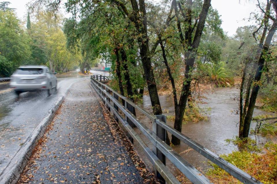
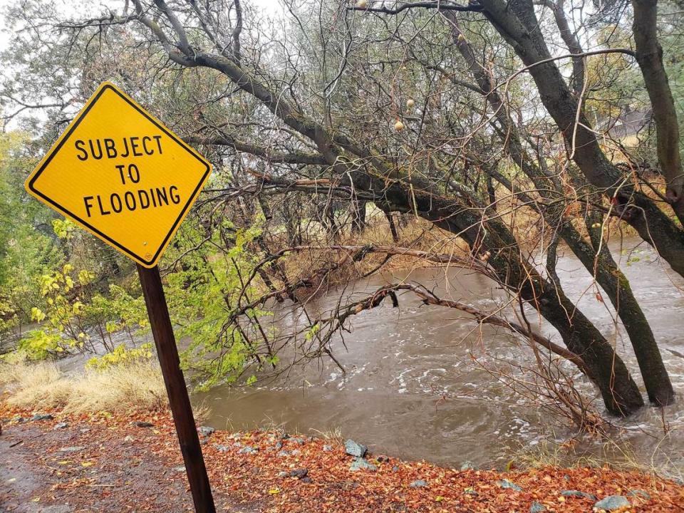
Arcade Creek, a tributary of the Sacramento River, was seen swollen with rainwater along Winding Way at Walnut Avenue. That area of Winding Way is prone to flooding, as a street sign indicates to drivers passing through.
As of 9:30 a.m., Arcade Creek was approaching the monitor stage, which indicates that roadway flooding is possible. It would need to rise by three feet in order to hit flood stage. Since Saturday, the water has risen by seven feet as rain poured over the region, according to Sacramento County flood monitoring data.
Localized flooding and a few street lights out of order were seen on Watt Avenue in the Arden Arcade section of Sacramento County.
Forecasters said more problems were likely as the storm intensifies. The heaviest rainfall was expected to arrive late Sunday before tapering off Monday.
—DALE KASLER and VINCENT MOLESKI
9 a.m.: Evacuations near Santa Cruz, warnings in Nevada County
Emergency authorities ordered mandatory evacuations for parts of San Mateo and Santa Cruz counties Sunday morning due to dangerous debris flows expected in areas scarred by the CZU Lightning Complex, a large cluster of wildfires that burned last year.
Evacuation warnings were upgraded to orders around 8 a.m. and include areas near the Santa Cruz Mountains. A live map of evacuation orders is available online at community.zonehaven.com.
Nevada County has issued evacuation warnings for areas west of Colfax, downslope from Mount Olive. Those areas were burned by the River Fire this August.
The Nevada County warnings as of 9 a.m. had not been upgraded to mandatory evacuation orders.
—MICHAEL MCGOUGH
8:30 a.m.: Rain totals coming fast in capital region
The storm, which is expected to intensify through Sunday, has already brought in some significant precipitation amounts.
Sacramento Executive Airport, for example, has received 1.25 inches of precipitation in the past 12 hours, according to the National Weather Service. Midtown has received 1.34 inches in the same span while a mobile rain gauge in the National Weather Service’s parking lot in Arden Arcade has received 2.36 inches in that span.
Woodland has received 1.06 inches, Davis 1.02, Elk Grove 1.27 inches and Colfax 1.87.
Other rain monitoring stations, collected by Sacramento County, show more significant 12-hour totals elsewhere.
Orangevale has received 1.62 inches in the 12 hours ending at 8 a.m., with nearly an inch falling since 3 a.m.
Other areas that received more than an inch in the past 12 hours: Roseville, American River College, Elder Creek at Stockton Boulevard, Alta Arden Expressway, the Cosumnes River at Wilton, Pleasant Grove and Mather Airport near Rancho Cordova.
And a harbinger of what’s to come can be seen in the rainfall totals in the Bay Area. Several locations in Marin and Sonoma counties have recorded more than 5 inches of rain in a 12-hour period, including Mount Tamalpais with 7.03 inches, Ross receiving 5.61 inches and Lagunitas getting 4.26 inches.
—DANIEL HUNT
8 a.m.: Flash flood warnings issued in burn areas
The National Weather Service has issued at least three flash flood warning for areas of the Sierra foothills that were burned by wildfires this summer.
Such warnings, an elevated level over a flash flood watch, means a flash flood is imminent, says the weather service.
The warnings were issued for areas of the Caldor Fire in El Dorado County, the Dixie Fire in southwestern Lassen and northwestern Plumas counties and the Beckwourth Complex fire scars in southeastern Lassen County.
—DANIEL HUNT
7:30 a.m.: Some roadways already having issues
What’s come of the rain and wind has already impacted Sacramento area roadways. Electronic signs throughout the area are alerting motorists to “watch for flooding all areas.” along Interstates 5 and 80 and Highways 50 and 99.
Several lanes of Interstate 5 have been closed between Florin Road and Seamas Avenue in the Little Pocket and South Land Park areas due to “extensive flooding,” according to Caltrans. Several of the adjacent on-ramps were also closed as Caltrans crews worked on clearing drains.
A wind advisory is in effect on the Yolo Causeway portion of Interstate 80, due to high winds. Travel is not recommended for campers, trailers or permit loads, Caltrans said.
Highway 70 is also closed at Jarbo Gap to the Greenville Wye due to multiple slides in the Caldor Fire scar areas, Caltrans said.
—DANIEL HUNT
7 a.m.: Storm bearing down on Sacramento
Rain is expected to intensify later this morning, especially around the Interstate 80 corridor. And forecasters say around 3 p.m., stronger bands of clouds are expected to drop a significant amount of rain in the Sacramento area, as well as the foothills.
Winds are also expected to be strong throughout the day, possibly peaking late morning or early afternoon. Sacramento International Airport has seen gusts top 41 mph. But some areas, especially in the southern Sacramento Valley, are expected to gust to 50 mph in the afternoon.
The storm is being produced by bombogenesis, or a “bomb cyclone,” which refers to a very rapid, significant drop in atmospheric pressure.
—DANIEL HUNT
6:43 a.m.: Ironman Sacramento canceled
Ironman California canceled its Sacramento debut Sunday morning, citing weather conditions that would prevent “acceptably safe” swimming and biking conditions.
“The safety of the athletes, volunteers and spectators is our highest priority. It would not be responsible to host the event at this moment in time,” the organizers said in a social media post around 6:30 a.m.
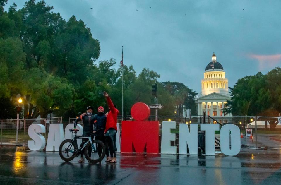
The race had 3,500 registered competitors, including some of the best athletes in the world. Followers on the race’s Facebook page mostly applauded the decision Sunday morning as strong winds accompanied heavy rains in Sacramento.
—JIM PATRICK

