
 Yahoo Movies
 Live updates Wednesday: Tropical storm warning issued for Beaufort County
‘Significant’ damage across Beaufort County
Updated 8:30 p.m.
Beaufort County emergency crews responded to 111 storm-related incidents between noon and 7:30 p.m. Wednesday — a “significant” number considering Idalia’s relatively modest winds, said Sheriff’s Office spokesperson Maj. Angela Viens.
First responders are expecting calls to continue into the early hours of Thursday morning, Viens said. Reports of fallen trees, downed power lines or other storm-related damage can be made to the Sheriff’s Office non-emergency dispatch line at 843-524-2777.
- Evan McKenna / emckenna@islandpacket.com
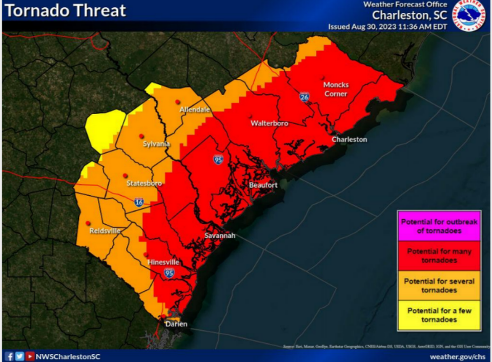
Highest threat timing 7-10 p.m.
Updated 6:45 p.m.
As Tropical Storm Idalia moves closer to South Carolina, the storm is gradually weakening, said Ron Morales, NWS Charleston meteorologist, during a 6 p.m. weather briefing.
The impacts to the Lowcountry will be “lower than we originally thought,” Morales said, adding that heavy rainfall, coastal flooding and isolated tornadoes still remain a threat.
Storm surge could be anywhere from 3 to 5 feet above normally dry ground and winds will reach speeds of 40 to 60 mph. The highest threat timing is between 7 p.m. and 10 p.m.
“(We’re) quite concerned with tide levels, because there’s still strong onshore flow during the time of high tide,” Morales said.
The bulk of rain is going inland, which Morales said was good news for the coastal areas that are now “pretty much done with heavy rainfall.” However, some rain bands could contain tropical storm force wind/wind gusts and there is potential for “many” isolated, short-lived and weak tornadoes.
Morales said that Idalia’s impact “should be out of here tomorrow.”
During the weather briefing, Idalia was in the western part of Chatham County, Georgia.
- Sarah Haselhorst / shaselhorst@islandpacket.com
Trees down, winds picking up and power outages
Updated 6 p.m.
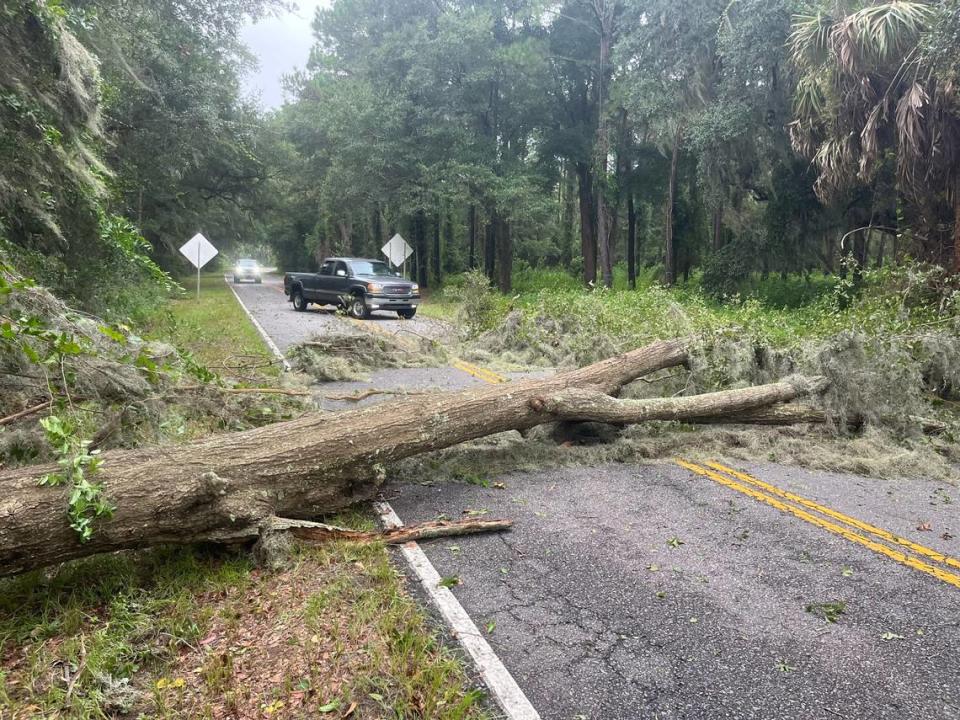
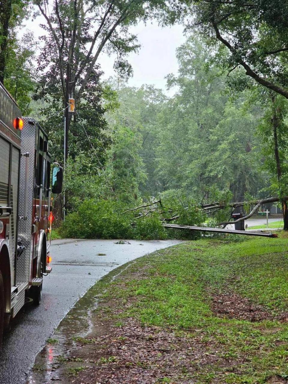
Even before Idalia had yet to really blow, winds picking up speed and frequency left branches and palm fronds scattered across roads throughout Hilton Head Island and Bluffton and took down trees in some places.
“Trees and (power) lines are down county-wide,” said Angela Viens, a sheriff’s office spokeswoman
In Beaufort, traffic lights were out in some places and a handful of trees had felled. Winds are getting increasingly stronger enough to push you at round a little bit with gusts.
Across the county, wind gusts were strong enough to push around a person. But some people in Beaufort and Port Royal weren’t deterred, as they sat on their porches as if we’re any other summer evening.
Residents of Sun City Hilton Head reported spot outages in the neighborhood of roughly 16,000. While reports of power outages are spreading to more areas, the overall number of customers without power has fallen since 5 p.m., when PowerOutage.US reported roughly 13,000 South Carolinians without power.
That number decreased to 4,931 as of 5:30 p.m., according to the website’s data.
In Beaufort County, 7,887 customers were without power at about 5:50 p.m., according to PowerOutage.US.
- Blake Douglas / bdouglas@islandpacket.com, Evan McKenna / emckenna@islandpacket.com, Karl Puckett / kpuckett@islandpacket.com and Sarah Haselhorst / shaselhorst@islandpacket.com
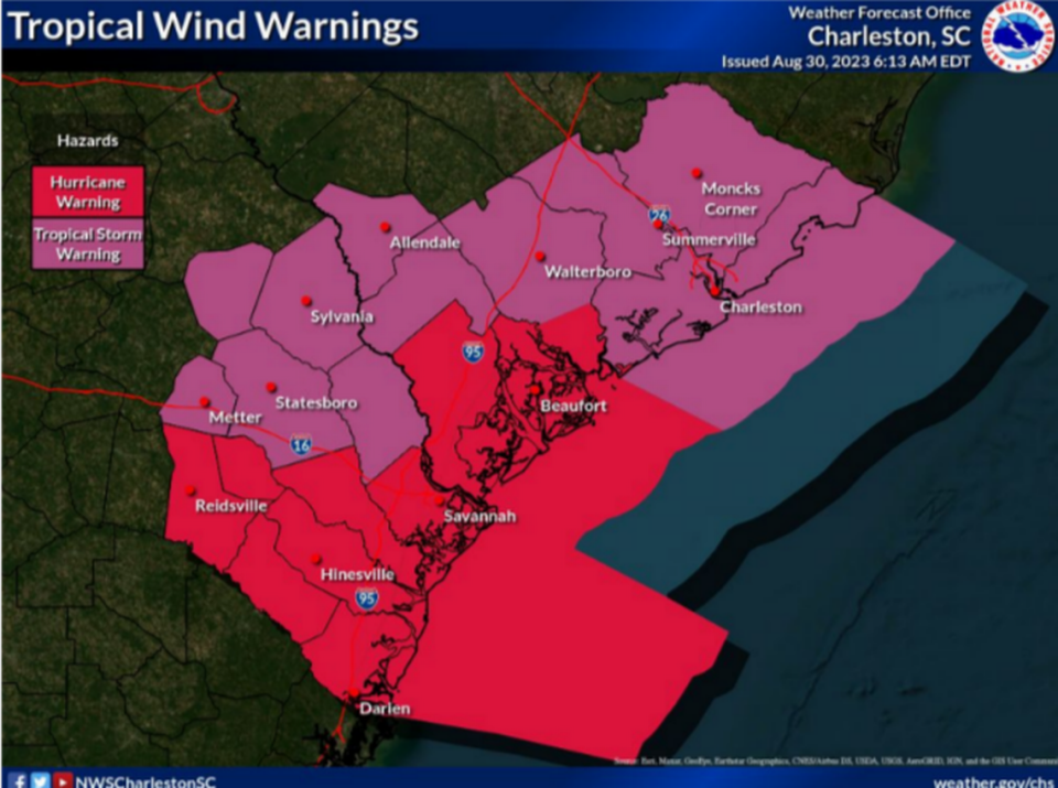
Hurricane warning swapped for tropical storm warning
Updated 5:10 p.m.
As Tropical Storm Idalia is making her way closer to the South Carolina coast, the National Weather Service issued a tropical storm warning for Beaufort County. The service canceled the hurricane warning. A storm surge warning and tornado watch remain in effect.
A tropical storm warning means tropical storm-force winds are expected somewhere within the area in the next 36 hours, according to the NWS.
Peak wind forecast is predicted to be 50-65 mph, with gusts to 80 mph, and will last through Thursday morning.
Life-threatening storm surge is possible with peak storm surge inundation to potentially be 3 to 5 feet above ground somewhere within surge prone areas. The window of concern is through early Thursday morning.
- Sarah Haselhorst / shaselhorst@islandpacket.com
Idalia now a tropical storm
Updated 4:50 p.m.
After spending the majority of Wednesday as a hurricane that made landfall on Florida’s Gulf Coast in the early morning and weakened throughout the day, Idalia has weakened to a tropical storm.
At the time of the 4:50 p.m. alert, Idalia was 40 miles west of Savannah and packing winds up to 70 mph, according to NOAA.
Even as a downgraded storm, there are still risks of freshwater flooding, storm surge and strong winds as Idalia continues to move across portions of Georgia and into South Carolina.
- Sarah Haselhorst / shaselhorst@islandpacket.com
Hurricane Idalia expected to weaken
Updated 3:45 p.m.
Hurricane Idalia is expected to weaken as the storm passes through Georgia and into the Lowcountry, a Beaufort County Sheriff’s Office alert said.
According to the National Hurricane Center, Idalia could still produce hurricane-force winds, especially gusts, throughout the night. The risk for isolated tornadoes remains.
The alert reminded people in Beaufort County to stay off the roads unless absolutely necessary, because as wind speeds pick up, it’s unsafe to travel across elevated roads and bridges. As of 3:45 p.m., all bridges in the county were open.
- Sarah Haselhorst / shaselhorst@islandpacket.com
Power outages, storm-related damage, HHI local state of emergency
Updated 2 p.m.
With more than 100,000 customers without power in each of the two states Idalia has blown through, early power outages in South Carolina are slightly above 1,000 customers. In Beaufort County, 160 customers are without power, according to Poweroutage.us, a website that tracks power availability.
With expected hurricane-force winds and rains stiffening in the evening, that number may increase significantly in the county. State officials expect 200,000 customers across South Carolina to lose power, according to a Hurricane Idalia update press conference held by the governor’s office.
Utility crews are not able to start repairing power lines until wind speeds are consistently under 35 mph, said Nanette Edwards, director of the states Office or Regulatory Staff.
According to the Beaufort County Sheriff’s Office’s Facebook page, its communication center had already received several storm-related calls. The office reported a downed tree that snapped a power pole in the Old Miller Road area in Bluffton.
To report downed trees or other storm-related debris/damage, call the office’s non-emergency dispatch line at 843-524-2777.
Hilton Head Island Mayor Alan Perry declared a HHI local state of emergency for the island beginning Wednesday and continuing through Sept. 3.
“This storm has the potential to be dangerous,” Perry said. “To ensure the safety of our residents and our community, I find it necessary to take this step so we can begin to implement appropriate measures to protect us from the impact of Hurricane Idalia before it strikes our area and to prepare us to deal with any of the after-effects.”
A local state of emergency gives the town manager, emergency manager and recovery coordinator authority to execute emergency management plans to prepare for and respond to any impacts from Idalia. It also grants the Beaufort County Sheriff’s Office authority to enforce curfews, re-entry and other short-term measures related to the hurricane.
- Sarah Haselhorst / shaselhorst@islandpacket.com
Idalia predicted to hit Beaufort County as a hurricane, tornadoes are possible
Updated 12:45 p.m.
Idalia is predicted to hit Beaufort County as a hurricane, instead of a tropical storm with a potential for 58 to 73 mph winds, according to the Charleston office of the National Weather Service. There is also a possibility of many tornadoes.
There is a hurricane warning, meaning that hurricane conditions are expected, instead of a watch which means that conditions are possible. Hurricanes have sustained winds of at least 74 mph, while tropical storms have sustained winds of 39 to 73 mph.
“Don’t get too caught up in the strength of it,” Charleston NWS Meteorologist Ron Morales said. “We’re still expecting, you know, heavy rain, tornado threat, coastal flooding and all that whether it’s a low-end hurricane or a tropical storm.”
Morales warned that nighttime tornadoes can be particularly dangerous, but typically tropical tornadoes are weak and short-lived.
“These tend to spin up out over the water and then move inland and as they move in they usually weaken,” he said.
The highest coastal flooding is expected this evening from 6 p.m. to 10 p.m. with peak storm surges up to 6 feet.
The service predicts that Beaufort County will get 1 to 4 inches of rain between now and tonight, missing the highest rainfall amounts which are expected to be west of I-95.
- Mary Dimitrov / mdimitrov@islandpacket.com
Beaufort County declares state of emergency
Updated 12:24 p.m.
Beaufort County is under a state of emergency until Sept. 3. The declaration allows government officials to take actions such as imposing curfews and travel limits, though none have been issued so far.
- Mary Dimitrov / mdimitrov@islandpacket.com
Idalia crossing into Georgia as a Category 1
Updated 11:17 a.m.
About 165 miles southwest of Savannah, Georgia, Hurricane Idalia is crossing into Georgia as a Category 1 with maximum sustained winds of 90 mph, according to the National Oceanic and Atmospheric Administration.
- Mary Dimitrov / mdimitrov@islandpacket.com
Beaufort County under tornado watch
Updated 10:57 a.m.
The National Weather Service Charleston issued a tornado watch for parts of North and South Carolina including Beaufort County until 10 p.m. Wednesday.
A tornado watch is issued when severe thunderstorms and tornadoes are possible in and near the watch area, according to the service. It doesn’t mean they will happen. It only means they are possible.
A tornado watch has been issued for parts of North Carolina and South Carolina until 10 PM EDT pic.twitter.com/KNNVyWermn
— NWS Charleston, SC (@NWSCharlestonSC) August 30, 2023
- Mary Dimitrov / mdimitrov@islandpacket.com
Capital Waste suspends trash pickup and recycling service
Updated 10:54 a.m.
All Capital Waste services in the Lowcountry have been suspended Wednesday, according to the business’ Facebook page. Recycling services will be suspended for the rest of the week and will resume regular schedule Monday.
-Lisa Wilson / lwilson@islandpacket.com
Talmadge Memorial Bridge closing
Updated 10:02 a.m.
Due to expected high wind speeds, the bridge into Savannah from Highway 17 will close to vehicular traffic at 2:00 p.m., Wednesday.
“The predicted strength of the wind at these bridges’ elevation will render vehicles susceptible to incidents. Motorists attempting to navigate vehicles across these bridges in conditions with the high wind levels anticipated from Hurricane Idalia may not be able to properly control their vehicles,” said the Georgia Department of Transportation in a press release.
-Sebastian Lee / Slee@islandpacket.com
Hilton Head Island Airport and Savannah Hilton Head International flight cancellations
Updated 8:59 a.m.
All flights scheduled for Wednesday, arrivals and departures, at the Hilton Head Island Airport have been canceled, John Rembold, Director of Airports for Beaufort County, said.
Some flights out of Savannah Hilton Head International canceled as well.
American Airlines and United Airlines flights at Savannah Hilton Head International have been canceled, according to the airport’s arrivals and departures page.
-Sebastian Lee / Slee@islandpacket.com
Daufuskie Island Ferry service suspension
Updated 8:59 a.m.
The ferry service to Daufuskie Island will be suspended Wednesday after the 11:30 a.m. departure from Daufuskie Island. The 1 p.m. and 4 p.m. ferries departing Buckingham and 2:30 p.m. and 5:30 p.m. ferries departing Melrose Landing are canceled.
The ferry plans to resume operations on Thursday.
-Sebastian Lee / Slee@islandpacket.com
Hurricane Idalia makes landfall in Florida
Updated 8:30 a.m.
At 7:45 p.m. Wednesday morning Idalia, as a Category 3 hurricane, made landfall along the coast of the Florida Big Bend near Keaton Beach. Maximum sustained winds were estimated to be 125 mph. The National Oceanic and Atmospheric Administration forecasts it will be at hurricane strength as it hits southeast Georgia late this afternoon, then gradually weaken to a tropical storm as it goes along the South Carolina coast.
Idalia is forecast to be at hurricane strength as it reaches southeast GA late this afternoon, then becoming a tropical storm as it tracks along the SC coast.https://t.co/3jVyiczXiy pic.twitter.com/bw6z9SLEyt
— NWS Charleston, SC (@NWSCharlestonSC) August 30, 2023
At 5:20 a.m. Beaufort County went under hurricane and storm surge warning, meaning that there is a danger of life-threatening inundation, from rising water moving inland from the coastline, somewhere within this area within the next 36 hours. It is under the warnings until further notice.
7:45 AM EDT update: Extremely dangerous Category 3 Hurricane #Idalia makes landfall in the Florida Big Bend. Maximum sustained winds were estimated to be 125 mph. Catastrophic storm surge and damaging winds ongoing. pic.twitter.com/umMdj8dD5d
— National Hurricane Center (@NHC_Atlantic) August 30, 2023
There is a flood watch in effect from Wednesday at 8 a.m. until Thursday at 2 a.m.
-Mary Dimitrov / mdimitrov@islandpacket.com

