
 Yahoo Movies
 Hurricane Ian plummets to Cat 1, but still forecast to hit Central Florida with strong winds
This article tracking Hurricane Ian is available for free as a public service to all readers.
Hurricane Ian saw its wind speeds plunge Wednesday night after hitting Florida’s southwest coast as a historic Category 4 storm and then — in a span of eight hours — downgrading to a Category 1.
While Ian saw rapid weakening, it is still a large hurricane battering the state with winds, storm surge and flooding as it treks up toward Central Florida. Forecasters are still cautioning residents to adhere to hurricane and tropical storm warnings.
As the storm’s intensity slowed down, certain watches and warnings have been discontinued: the hurricane watch for Lake Okeechobee; the tropical storm storm warning south of Boca Raton; the storm surge watch from Flamingo eastward to the Card Sound Bridge, including Florida Bay.
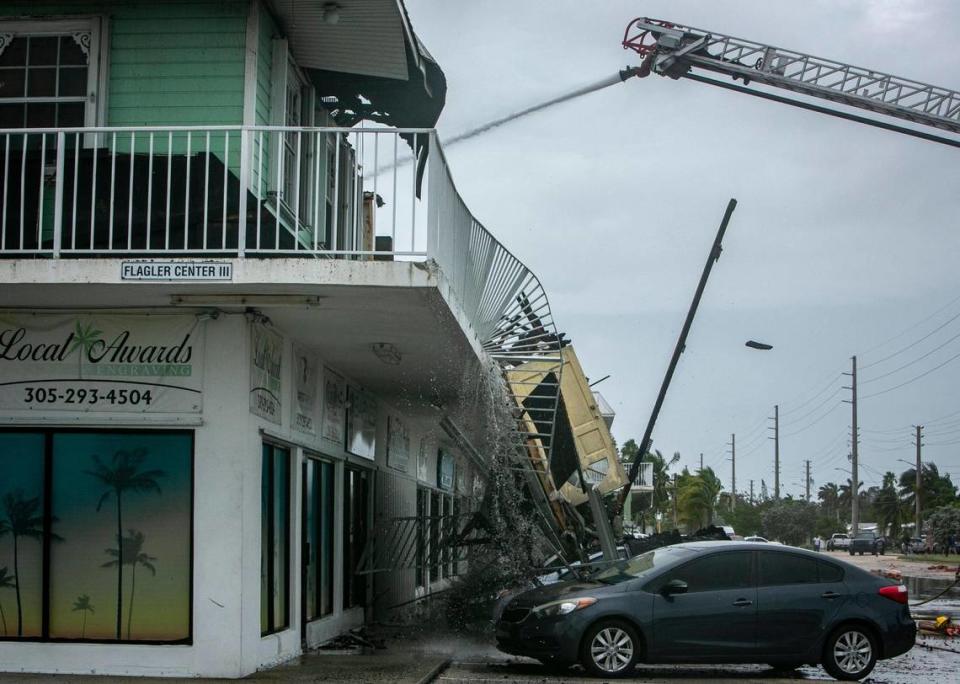
Ian has already brought record-breaking storm surge highs for Key West, Fort Myers and Naples several feet above previous high water marks.
Numerous videos posted on the internet show torrents of seawater rapidly filling streets in Sanibel, Fort Myers Beach and Naples — washing away stop signs, cars, boats and homes. Entire city blocks were submerged Wednesday afternoon, and forecasters noted the worst of the surge was yet to come.
Ian followed an eerily similar path to the last storm to menace southwest Florida as a powerful hurricane and buzz-saw its way up the Interstate 4 corridor — 2004’s Hurricane Charley.
But Ian is a far bigger, wetter and slower storm. Its wind field covered most of the state on Wednesday, and its projected path as a strong but slow-moving storm across Central Florida is expected to last another full day as it drenches the middle of the state with near-record rainfall.
Over two million Floridians were without power Wednesday night — a number that is expected to soar as Ian crosses the state. Utility leaders cautioned that it could take a while for the lights to come back because they need to rebuild parts of the grid crushed by Ian’s Category 4 winds.
Hundreds of Floridians who didn’t evacuate ahead of Ian were calling for rescue, and with 911 centers down in big, affected counties like Lee, officials don’t yet know how many might need to be saved.
Gov. Ron DeSantis said rescue crews will move in by land, air and water as soon as it’s safe, and noted he’d asked the Department of Defense for extra high water vehicles and aerial rescue equipment to help the response.
“Those people are being logged, and there will be a response,” DeSantis said. “But it’s likely going to take a little time for the storm to move forward so that it’s safe for the first responders to be able to do that.”
While the worst of the winds and surge had faded for the Florida Keys by Wednesday afternoon, it left behind flooded homes and impassable streets. South Florida saw tornadoes overnight that flipped small airplanes, cracked apartment buildings in half and took down big trees as the streets flooded under the heavy rains and high king tides throughout the day Wednesday.
Ken Graham, director of the National Weather Service, called Hurricane Ian a “historic event.”
“This is going to be a storm we talk about for many years to come,” he said.

Ian up the I-4 corridor
Hurricane Ian’s winds continued to dramatically weaken after it came ashore Wednesday afternoon, with maximum sustained winds dropping to 90 mph by 11 p.m. from a peak of 155 mph.
As of a 11 p.m. NHC update, Ian was about 70 miles south of Orlando and about 80 miles southwest of Cape Canaveral. The storm was moving north-northeast near 8 mph.
The Cat 1 storm’s hurricane-force winds extend up to 45 miles from the center; tropical-storm-force winds extend up to 175 miles.
The storm is expected to move across Central Florida overnight and Thursday morning, and emerge over the western Atlantic by late Thursday as a tropical storm with maximum sustained winds around 65 mph.
“As you see it move inland you’ll see the eye start to diminish but don’t let that fool you, it will still pack a formidable punch as it moves across the state of Florida up the I-4 corridor over the next couple of days,” said Jamie Rhome, acting director of the hurricane center.
Forecasters warn that while Ian will weaken, it still could be at hurricane strength when it reaches the central east coast of Florida.
The hurricane center declared the storm made landfall around 3 p.m. near Cayo Costa, an island just north of Captiva and off the coast of Fort Myers with few full-time residents and reachable only by boat.
The eyewall moved ashore on Captiva and Sanibel Islands, live traffic web cameras showed storm surge overwhelming streets, rising higher than mailboxes and stop signs before the cameras cut out. Naples was experiencing six feet of storm surge and rising, blowing away the previous record of just over four feet.
A second landfall on the mainland, near Pirate Harbor and north of Punta Gorda, happened around 4:35 p.m.
Bill Karins, a meteorologist with NBC’s climate unit, tweeted that the worst storm surge will likely occur after landfall, when the highest winds come ashore.

‘Catastrophic’ storm surge
Storm surge forecast totals lowered Wednesday night. The middle of Englewood to Bonita Beach, including Charlotte Harbor, was forecast to see the most storm surge, with 8 to 10 feet possible. Earlier in the day, this region saw surge as high as 12 feet.
“No one alive has seen 12 feet of storm surge in that area, and many areas could take years to recover. Please be safe!” tweeted Eric Blake, a senior meteorologist for NHC.
I can't overstate how serious the storm surge threat is in southwest Florida. #Ian will drive deadly surge into Cape Coral and Fort Myers, placing much of the area under water. If you live near the ocean in a surge zone, this is your last chance to leave... pic.twitter.com/FefKkoltd3
— Evan Fisher (@EFisherWX) September 28, 2022
The hurricane center predicted up to 30 inches for central and northeast Florida this week.
Hurricane Ian approached the state with 155 mph winds, two mph shy of Category 5 status, before weakening to 150 mph by landfall.
Nine storms have reached Category 5 status while at sea but only four have made landfall at that strength in the U.S. — three of them in Florida. The most recent was Michael, which hammered the Panhandle in 2018. Andrew devastated South Miami-Dade in 1992 and an unnamed storm now known as the Labor Day hurricane swept the Florida Keys in 1935. Camille roared into the Mississippi coastline in 1969. All four of those Cat 5 hurricanes were tropical storms three days before landfall.
“I think we’re going to end up seeing that it may end up being a Category 5,” DeSantis said. “But at a minimum, it’s going to be a very strong Category 4 that’s going to rank as one of the top five hurricanes to ever hit the Florida peninsula.”
READ MORE: ‘Dirty side’ or not? With Hurricane Ian, it could make big difference along Florida coast
Echoes of Charley
For Southwest Florida, 2004’s Hurricane Charley is the yardstick for the worst storm they’ve lived through. The Category 4 storm came through like a small buzz saw, crossing the state and exiting near New Smyrna Beach.
Charley killed 30 Floridians and caused more than $5 billion of damage. Power was out for weeks in some spots, and public schools were closed for two weeks in some Central Florida counties.
Now another strong storm is tearing through the same region, but meteorologists and emergency managers are warning residents that it’s not the same storm, despite the similar track. Ian is slower, bigger and wetter than Charley, and the population of the region has grown dramatically, putting more people in the bullseye.
Wind field comparison of Charley (2004), Irma (2017), and #Ian (2022; In Progress). Charley and Ian made landfall in the same place and will likely end with a similar path across the Florida Peninsula. But the complete physical damage impacts will be much more robust with Ian. pic.twitter.com/wIvXvPZH5U
— Steve Bowen (@SteveBowenWx) September 28, 2022
“This is not Hurricane Charl[ey], but something you have never experienced,” tweeted Craig Fugate, who led the state’s emergency management response to Charley in 2004.
Before making landfall Wednesday, Hurricane Ian’s eye was double the size of Charley’s tight 7-mile wide eye, and its wind field was also far larger, with tropical-storm-force winds extending up to 175 miles. Charley’s wind field was far smaller, with tropical storm winds extending out around 70 miles from the center.
#Ian is not #Charley...
Although the tracks of Cat4 Ian '22 and Cat4 Charley '04 are eerily similar, the sizes are VERY different. As of 5am Wednesday, Ian's area of hurricane-force winds is 2.9 times larger, and its area of tropical storm force winds is 2.3 times larger. pic.twitter.com/wCWPiJDzfh— Brian McNoldy (@BMcNoldy) September 28, 2022
Charley also rushed through the state as an unusually fast storm, with speeds of 20 to 25 mph. Hurricane Ian is forecast to be much slower, with speeds from 10 mph to 5 mph. That slowdown will allow it to dump incredible amounts of rain across most of the state and push “catastrophic” levels of storm surge ashore.
Charley brought 5 to 8 inches of rain to the state, while Ian could bring up to 24 across most of Central Florida.
A final factor that could make Hurricane Ian far more devastating than Charley is the number of people and buildings at risk.
Population in the counties closest to landfall has grown by more than half a million since 2004, tweeted Matt Lanza, a meteorologist for Space City Weather in Houston.
READ MORE: Piney Point threatened by Hurricane Ian, but rain won’t be the problem, operator says
Recovery measures already in place
Officials are indicating that most of the damage from Ian could be from flooding, which could pose a serious problem for people in parts of the state who might not have flood insurance.
Citizens Property Insurance, the state-run insurer of last resort that covers more residences than about any other company, said Wednesday it estimates it may see 225,000 claims from Hurricane Ian. The company doesn’t offer flood insurance, which is mostly offered through the federal National Flood Insurance Program.
Preliminary estimates, also made before landfall, indicate $3.8 billion in losses for Citizens, spokesperson Michael Peltier said.
Ahead of the storm, President Joe Biden promised aid to residents in Florida, some of whom were already calling 911 for rescue Wednesday evening.
”We’ll be there to help you clean up and rebuild, to help Florida get moving again,” Biden said. “We’ll be there every step of the way. That’s my absolute commitment to the people of Florida.”
FEMA Administrator Deanne Criswell, speaking from the agency’s headquarters in Washington, said Wednesday that the federal government has gone to great lengths to prepare for Ian’s arrival.
FEMA has readied 128,000 gallons of fuel for rapid deployment, she said, and the Army Corps of Engineers has pre-positioned 350 personnel to help restore power to areas of the state as soon as the storm passes.
The FEMA chief also said 3.7 million meals and 3.5 million liters of water have been placed in Alabama, ready to be sent to the state when needed. The agency has also sent Florida 300 extra ambulances ahead of time.
Search and rescue teams from a variety of government entities, including FEMA, the Department of Defense and the state of Florida, have also been stationed in Miami.
“I can confidently say that we have the right teams and we have the right resources in place and ready to meet the changes or the needs of those that we are charged to serve,” Criswell said.
Kevin Guthrie, the state’s emergency management director, said the state was staging shallow draft vehicles to prepare for search and rescue missions for people stranded by flooding.
At a Tuesday evening briefing of the state’s emergency operations staff, Guthrie added another warning: They should be prepared to work long hours for the next few weeks as they manage search and rescue operations.
“It’s going to be a humanitarian, heavy-duty lift,’‘ he told them. “People are going to lose a lot of the contents of their homes, but their homes are still going to be standing — and that’s just crushing.”
“This is gonna take a lot of special people to get out there and do that. And you guys are a lot of special people.”
This article will be updated.
McClatchy staff writers Michael Wilner and Alex Roarty and Miami Herald/Tampa Bay Times bureau reporters Mary Ellen Klas and Lawrence Mower contributed to this report.

