
 Yahoo Movies
 Hurricane season continues to buzz with activity as Tropical Storms Peter and Rose spin in the Atlantic
The 2021 hurricane season continues to buzz with activity as two tropical storms and two other disturbances were all in action Monday across the Atlantic basin.
Tropical Storm Peter, which formed Sunday, could bring heavy rain to portions of Puerto Rico, the Virgin Islands and the northern Leeward Islands, the National Hurricane Center said. The rain could lead to "areas of urban and small stream flooding through Tuesday."
In addition to the rain threat, swells generated by Peter are expected to affect the northern Leeward Islands early this week, then reach the Bahamas by midweek. "These swells could cause life-threatening surf and rip current conditions," according to the Hurricane Center.
As of 11 a.m. EDT Monday, the center of Peter was about 170 miles east-northeast of the northern Leeward Islands, the center said. Peter moved west-northwest at 15 mph with top winds of 50 mph.
Looking at the future of the storm, AccuWeather meteorologist Randy Adkins said, "Peter is not anticipated to intensify past a low-end tropical storm as it encounters a combination of wind shear and drier air, which will prevent the storm from strengthening over the coming days."
The hurricane center's forecast track shows Peter potentially approaching Bermuda by the weekend.
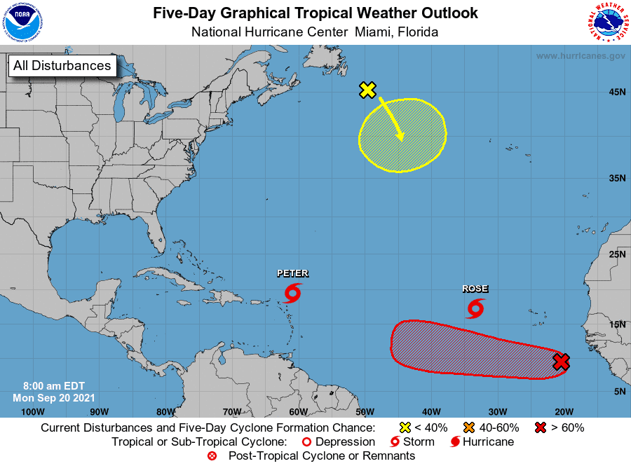
Tropical Storm Rose, which formed in the eastern Atlantic Ocean on Sunday, poses no threat to any land areas, the hurricane center said. As of 11 a.m. EDT Monday, the center of Rose was about 620 miles west-northwest of the Cabo Verde Islands, moving northwest at 16 mph. It had winds of 40 mph.
Rose is expected to continue to spin across the central Atlantic over the next few days and is likely to weaken into a depression by midweek, forecasters said.
The National Hurricane Center tracked two other weather disturbances Monday. The remnants of Tropical Storm Odette were a couple of hundred miles southeast of Newfoundland, Canada. This system could acquire subtropical characteristics by the middle of this week as it moves slowly southeast over warmer waters across the north-central Atlantic Ocean before moving north out of the area by the weekend.
The other system is a tropical wave over the far eastern Atlantic several hundred miles south-southeast of the Cabo Verde Islands. It is producing showers and thunderstorms that show signs of organization.
A tropical depression is likely to form by Friday while the system moves west at 10 to 15 mph across the eastern and central tropical Atlantic Ocean.
In the USA, the remnants of last week's Hurricane Nicholas plague portions of the South, the National Weather Service said Monday: "Moisture and the upper-level circulation associated with the remnants of tropical cyclone Nicholas will continue to pose a heavy rainfall and flash flooding threat, especially for portions of the Tennessee and lower Ohio Valleys and the southern Appalachians on Monday."
Contributing: Cheryl McCloud, Treasure Coast Newspapers
This article originally appeared on USA TODAY: Tropical Storms Peter and Rose are spinning in the Atlantic

