
 Yahoo Movies
 Hurricane Ian tracker: Latest maps, projections and possible paths

A major hurricane has made landfall in Florida, bringing with it the threat of high winds, dangerous storm surge and even tornadoes.
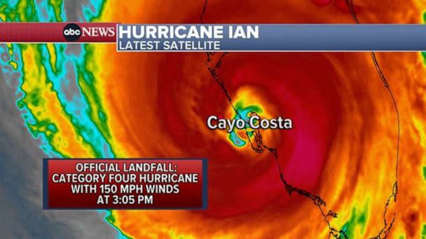
After traveling north through the Gulf of Mexico, Hurricane Ian made landfall along the southwestern coast of Florida around 3:05 p.m. ET as a Category 4 storm, with sustained winds near 150 mph, the National Hurricane Center said.
Landfall was near Cayo Costa, an island off the coast of Fort Myers.
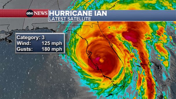
The storm was approaching Category 5 strength as it headed toward the coast.
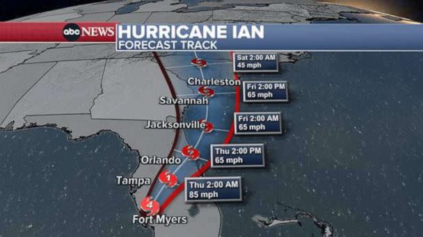
The storm has since downgraded to a Category 3 hurricane, with winds of 125 mph. It is expected to continue to weaken, becoming a Category 1 hurricane overnight as it passes Orlando. It is then forecast to move off the northeast coast of Florida before re-emerging in South Carolina as a tropical storm by Friday.
MORE: Hurricane Ian's latest path: 2.5 million Floridians under evacuation orders

Weather alerts due to Ian now extend across four states, from Florida to North Carolina.
Significant and possibly devastating impacts could extend far from the center of the storm. The entire Florida Peninsula is under either a hurricane or tropical storm warning. Hurricane warnings have been issued for Tampa and Fort Myers, extending south to Chokoloskee.

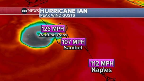
Sustained winds could exceed 115 mph in some parts. As Ian moves north, tropical storm force winds could reach coastal Georgia and South Carolina. Tropical storm watches have been issued for Savannah and near Charleston.
MORE: Everything you need to know about hurricanes
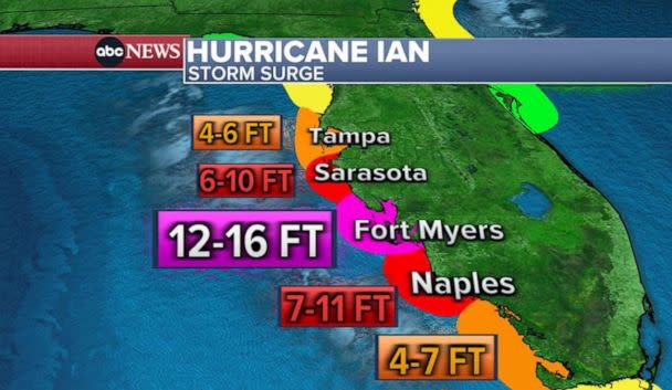
Life-threatening storm surge is possible, with up to 18 feet forecast along Florida's Southwest coast, from Englewood to Bonita Beach. Fort Myers could see up to 16 feet of storm surge and Bonita Beach to Chokoloskee could see up to 12 feet. Storm surge warnings are in effect for a large portion of the west coast of Florida, from Cedar Key to the southwest corner of the state.
Record flooding from torrential rains is also possible inland. The highest rain totals are expected in Central and Northeast Florida, where up to 18 inches of rain is forecast, with up to 30 inches possible in some areas. Overall, a swath large of the Florida peninsula and up along the coast to South Carolina is forecast to get more than half a foot of rain through the upcoming weekend.

Tornadoes are possible as Ian makes landfall and moves north through Florida. At least three were reported in South Florida Tuesday night as the storm approached. A tornado watch remains in effect for east-central Florida Wednesday evening.
Hurricane Ian tracker: Latest maps, projections and possible paths originally appeared on abcnews.go.com
