
 Yahoo Movies
 Hurricane Ian’s strong winds are menacing Florida. Check the threat in your area
Hurricane Ian’s powerful hurricane-force and tropical storm-force winds are lashing Florida as the storm made landfall on the state’s west coast Wednesday.
Ian is a large Category 4 storm, with maximum sustained winds of 140 mph and higher gusts. Its hurricane-force winds extend up to 50 miles from the center and its tropical storm-force winds extend up to 175 miles, according to the National Hurricane Center’s 5 p.m. advisory.
And the storm comes with plenty of baggage:
Flooding rain. Life-threatening storm surge. And strong gusty winds that are forecast to be felt across the state.
READ NEXT: How much storm surge will Hurricane Ian bring to Florida? See the risk by area
Ian’s eyewall was forecast to pass directly over eastern Manatee County on Wednesday afternoon. Additionally, Ian is expected to see major weakening as it moves into and across Central Florida toward the Atlantic.
How strong will Ian’s winds be across Florida? Here’s what the forecast shows:
When will all of Florida feel Hurricane Ian’s winds?
Nearly all of Florida, which is under several watches and warnings, is expected to feel Ian’s tropical storm-force winds by Wednesday night. Some areas are also expected to feel its hurricane-force winds.
Much of Florida’s Gulf Coast — from Chokoloskee to Anclote River, including Tampa Bay — is under a hurricane warning.
The rest of Florida’s Gulf Coast is under a tropical storm warning. A tropical storm warning is in effect for all of Florida’s eastern coastline, except for the Florida Keys and Florida Bay. On the eastern coastline, a hurricane warning is in effect from the Sebastian Inlet to the Flagler-Volusia line.

Which part of Florida will feel Ian’s stronger winds?
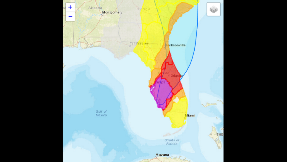
Here are some examples of how strong Ian’s winds could be in certain parts of the state. As a reminder, Cat 4 storms have maximum sustained winds ranging between 130-156 mph. Anything higher than this is considered to be a Cat 5. Cat 3 storms have maximum sustained winds of 111-129 mph, Cat 2 storms have maximum sustained winds of 96-110 and Cat 1 storms have maximum sustained winds of 75-95 mph. Tropical storms have maximum sustained winds of 39 to 73 mph.
The following information comes from the National Weather Service’s “Threat and Impacts” web page, which represent a “reasonable worst case scenario for planning purposes.”
▪ Much of Florida’s west coast, such as Port Charlotte, Tampa, Bradenton and Fort Myers could see winds greater than 110 mph. Category 4 winds start at 111 mph. Other parts of the Gulf Coast, such as Naples, Marco Island and Clearwater, might see winds ranging from 74 to 110 mph. These areas could see tropical storm-force winds up to Cat 3 hurricane-force winds.
▪ South Florida — Miami-Dade, Broward, Palm Beach counties — could see tropical storm-force winds ranging from 39 to 57 mph.
▪ Central Florida, including Orlando, Kissimmee, DeLand, as well as a swath of Florida’s east coast like Daytona Beach and Palm Bay, could see winds ranging from 74 to 110 mph. This means the areas could see tropical storm-force winds up to Cat 3 level winds.
▪ Other swaths of the state like Hendry, Martin, St. Lucie, Marion, St. John, and parts of Collier and Citrus counties could see tropical storm-force winds from 58 to 73 mph. Similarly, some parts of Duval County, home to Jacksonville, and parts of Alachua County, home to Gainesville, could see tropical storm-force winds from 39 to 57 mph — while other parts could see up to 73 mph winds.
Miami Herald staff writer Devoun Cetoute contributed to this report.
