
 Yahoo Movies
 Hurricane Ian makes landfall in Florida as winds hit 150mph
Hurricane Ian made landfall in southwest Florida on Wednesday as a massive Category 4 storm.
About 2.5 million people had been ordered to evacuate southwest Florida before the storm hit the coast with maximum sustained winds of 150 mph (241 kph). The storm was heading inland, where it was expected to weaken, but residents in central Florida could still experience hurricane-force winds.
Before making its way through the Gulf of Mexico to Florida, Hurricane Ian tore into western Cuba as a major hurricane on Tuesday, killing two people and bringing down the country's electrical grid.
It also caused destruction in Cuba’s world-famous tobacco belt.
The hurricane made landfall close to the heavily populated Fort Myers area of Florida on Wednesday evening UK time. Forecasters said the region could be inundated by a storm surge of up to 18 feet (5.5 meters).

“This is going to be a nasty nasty day, two days,” Florida Governor Ron DeSantis said early on Wednesday, stressing that people in Ian’s path along the coast should rush to the safest possible shelter and stay there.
“It’s going to get a lot worse very quickly. So please hunker down,” Mr DeSantis said.
The storm’s wind speeds put it just shy of a Category 5 designation on the Saffir-Simpson scale, the most severe classification for storms with maximum sustained winds of at least 157 mph, though Ian was expected to weaken a notch after coming ashore, according to forecasters.
The region around the landfall zone is home to miles of sandy beaches, scores of resort hotels and numerous mobile home parks, a favorite with retirees and vacationers alike.
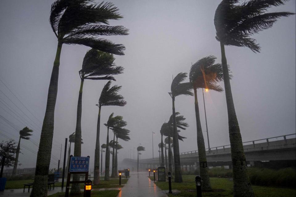
In Venice, a coastal city of nearly 24,000 residents halfway between Tampa and Fort Myers, rain and wind were already intense before noon. Many streets were flooded, and the steady gale bent palm trees at 45 degree angles and shredded billboards and road signs.
“This is a storm that we will talk about for many years to come, an historic event,” said Ken Graham, director of the National Weather Service.
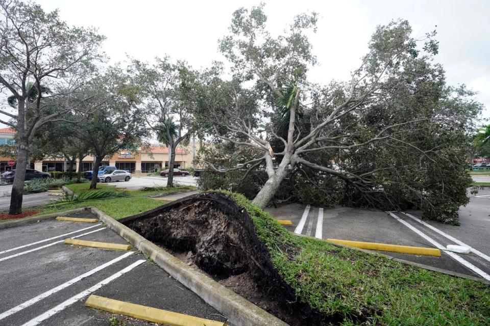
More than 524,000 homes and businesses were without power in Florida on Wednesday afternoon, according to local utilities In total, Ian has affected more than 830,000 customers so far, but power companies have restored some early outages.
Off the coast on Sanibel Island near Fort Myers, swirling water covered residential streets and was halfway up mailbox posts by mid-morning.
Seawater was pulled out of Tampa Bay, leaving parts of the muddy bottom exposed, and waves crashed over the end of a wooden pier at Naples.
More than 2.5 million people were under mandatory evacuation orders, but by law no one could be forced to flee. The governor said the state has 30,000 linemen, urban search and rescue teams, and 7,000 National Guard troops from Florida and elsewhere ready to help once the weather clears.
Florida residents rushed ahead of the impact to board up their homes, stash precious belongings on upper floors and join long lines of cars leaving the shore.
Forecasters predicted Ian would make landfall more than 100 miles (160 kilometers) south of Tampa and St Petersberg.

Forecasters placed roughly 120 miles (193 kilometers) of central Florida’s east coast under a hurricane warning Wednesday, signaling that Ian may remain a hurricane longer than previously expected as it moves inland.
Isolated tornadoes were spinning off the storm well ahead of landfall. One tornado damaged small planes and a hangar at the North Perry Airport, west of Hollywood along the Atlantic coast.
More than 190,000 homes and businesses were without electricity, and Florida Power and Light warned those in Ian’s path to brace for days without power.
Parts of Georgia and South Carolina also could see flooding rains and some coastal surge into Saturday. Georgia Gov. Brian Kemp preemptively declared an emergency, ordering 500 National Guard troops onto standby.
Meanwhile, heavy rain and 60mph winds and set to batter the UK more than 4,000 miles away, amid the fallout from the huge storm.
Flooding may affect parts of the country on Friday after torrential downpours, while a jet stream bringing low pressure will swoop in from the west coast, leading to possible wind damage, says Met Office.
The forecaster said this will follow mostly sunny spells and a few scattered showers on Thursday.
Speaking of the jet stream, Chris Almond, a meteorologist at the national weather service, said: “This will bring a much wetter and windier spell than we’ve seen so far this autumn, but nothing that is unusual for the time of year.
“The fast-moving system will bring strong gale force winds, locally in excess of 60mph, and heavy rain into the north west before pushing quickly south east through the day.
“We could see some minor impacts, such as surface water flooding or minor wind damage, as well as some short-lived impacts on ferry crossings, especially in exposed areas of western Scotland and eastern areas of Northern Ireland.
“Later in the day, parts of south-east England could experience winds of around 55mph, which may impact the English Channel too.”
The Met Office said showers, which may turn heavy, will continue in southern areas on Saturday, with some sunny spells further north.
