
 Yahoo Movies
 Hurricane Ian to hit Florida then march to Midlands where severe weather is forecast
Hurricane Ian has strengthened to a Category 4 storm and is expected to make landfall in southwestern Florida Wednesday, then move slowly north toward the Midlands, the National Weather Service said.
Although Ian is not expected to be at hurricane strength when it reaches the Columbia area, the storm is forecast to produce heavy rain, gusty winds, flash flooding, and isolated tornadoes, according to the National Weather Service.
Ian is forecast to be a tropical depression (wind speeds at 38 mph or less) when it tracks over the Aiken area and the western Midlands early Saturday morning, according to the National Hurricane Center. But its most powerful effects could arrive earlier than that.
Tropical storm wind gusts could exceed 30 mph, and up to 6 inches of rain could fall, the National Weather Service said. The amounts of rain could be heavier locally, while up to 8 inches is forecast for the South Carolina coast, the National Hurricane Center said.
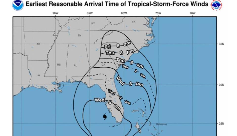
The Tropical Storm Force Winds are expected to lash the Midlands on Friday, and conditions will remain windy into Saturday, according to the National Weather Service.
The rain is forecast to start falling in the Columbia area Thursday and continue on through Saturday, meteorologists said in a hazardous weather outlook.
The heavy rain could result in flash flooding Friday through early Saturday, according to the National Weather Service. Meteorologists said the rain and potential flooding are the greatest threat posed to the Midlands by the storm.
There’s an 80% chance of rain on Friday, dropping slightly to 70% during the day on Saturday, according to the forecast.

The current forecast shows the potential for tornadoes is low, but any that form would also be a great threat.
Powerful winds and tornadoes could cause considerable damage to trees and branches, in addition to mobile homes, roofs and outbuildings. Vehicles would also be under siege in the case of a tornado.
Damage to trees and branches creates the possibility of downed power lines and outages.
As of Wednesday morning, no warnings, watches, or advisories were issued for the Midlands by the National Weather Service. That could change as the hurricane moves closer.
A storm surge watch and tropical storm watch were issued for some coastal areas of South Carolina, according to the state’s Emergency Management Division.
The National Weather Service said that all of the severe weather effects are subject to change based on Ian’s track, but is confident it will be windy and wet in the Midlands.

At a Tuesday news conference, S.C. Gov. Henry McMaster said he has not issued a state of emergency or ordered any evacuations along the coast as emergency managers monitor the storm.
The South Carolina Emergency Management Division has notified local and state agencies to be ready to respond if the need arises and said people in potentially vulnerable areas should consider actions they will need to take if the storm threatens the state.
“While we are not expecting the full force of a hurricane-strength storm, everyone in South Carolina, from the Upstate to the Midlands, the Pee Dee and the Lowcountry should be prepared to take personal safety precautions if advised to do so by your local emergency managers,” SCEMD Director Kim Stenson said Monday.
Conditions are expected to improve Saturday night as the storm continues to weaken while it tracks further north, according to the National Weather Service.
There’s a 40% chance of continued rain Saturday night, and while more rain is possible on Sunday and Monday, it’s even less likely, the forecast shows.
“The effects would move on by the end of the weekend as Ian pulls out of the area,” National Weather Service meteorologist Pierce Larkin told The State.
This will be the first named storm to hit the Columbia area since the remnants of Tropical Storm Fred washed through in August 2021, according to Larkin.
Ian is the fourth Atlantic hurricane of the season, and the first to make landfall in the continental U.S.
At 8 a.m. Wednesday, the Category 4 hurricane was moving northeast at 10 mph toward Florida, and had maximum sustained winds of 155 mph, according to the National Hurricane Center.
Hurricane-force winds extend out up to 40 miles from the center of Ian, while tropical-storm-force winds extend outward up to 175 miles, the National Hurricane Center said.
“Ian is expected to cause catastrophic storm surge, winds, and flooding in the Florida peninsula starting (Wednesday),” the National Hurricane Center said.

