
 Yahoo Movies
 B.C. residents brace for travel, power impacts from major snow event
The B.C. South Coast is in the middle of a significant snowfall event, with numerous winter warnings in place. Snow and blustery winds will bring difficult and dangerous travel, and possible power outages, through Wednesday.
This the first major snowfall of the season for parts of the Lower Mainland. The setup is due to a strong low-pressure system interacting with Arctic air, which is also sending temperatures plummeting.

While B.C. has seen several snow events in higher terrain, some areas like Burnaby and eastern areas of Vancouver Island have only had light snowfall accumulations so far this season.
The snowfall has already resulted in airport and BC Ferries delays.
Through Tuesday, snow accumulated quickly across portions of Vancouver Island, reaching Metro Vancouver by mid-afternoon. Snow will ramp up across the Lower Mainland through overnight Tuesday. Snow could transition to a wintry mix or straight rain for some in the lowest elevations along the coast into Wednesday. Heavy snow will continue in the southern Interior and at higher elevations.
Snow will transition to rain or taper off to a few showers or flurries early Wednesday morning for parts of Metro Vancouver and Abbotsford. For Fraser Valley east of Abbotsford, snow will taper off Wednesday evening.
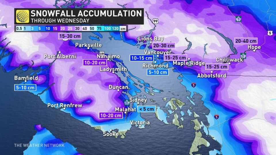
Through Wednesday morning, strong, southwest winds will mix down wind gusts in the 50-90 km/h range along the coast and Strait of Georgia. This may cause snow-covered tree branches to break and possible power outages.
Snowfall rates will intensify Tuesday overnight, potentially falling at rates of 5+ cm an hour for parts of Vancouver Island. Needless to say, travel is not recommended.
Snowfall totals across Metro Vancouver will range from 10-20+cm, with 20-30+cm for the Fraser Valley. Places like Richmond and Delta are forecast to see the lowest accumulations from 5-10 cm.
Related: Simple tricks for effectively priming your car for winter driving
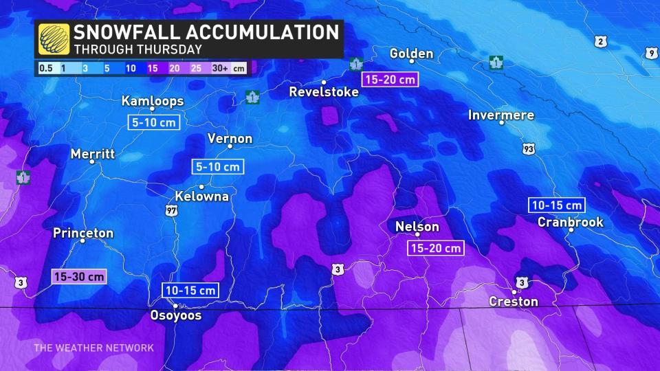
There will also be heavy snow for the alpine regions and difficult travel conditions across the Interior, with 5-15 cm anticipated for the Okanagan Valley.
WATCH: Pack your patience, YVR delays and cancellations begin
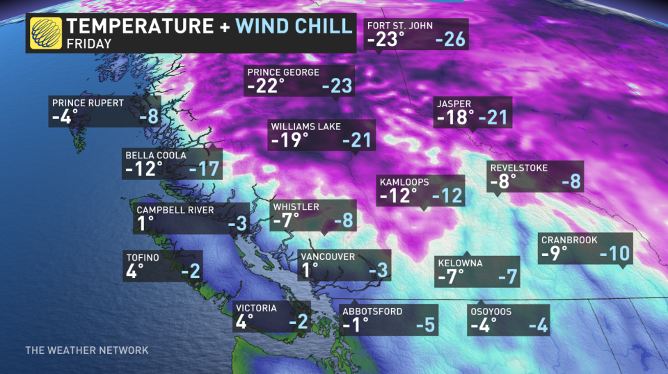
Cold, Arctic air will continue to push south into the Interior, as well. Falling temperatures over the next couple of days are expected as brisk outflow winds develop.
Be sure to check back frequently to The Weather Network for updates as this system has the potential to be a high-impact weather event.
A couple more rounds of snow are forecast for southern B.C. through early next week. The next system to watch will be late Friday into Saturday. One scenario is that this storm will stay too far offshore to have a significant impact on the region, though snow is possible for Tofino.
Another scenario would bring snow for Victoria but mostly miss the Lower Mainland. However, it is still possible that we will see snow across the Lower Mainland and Victoria. There will then be a potential for another round of light snow Sunday night and Monday. Colder than seasonal for the next two weeks.
Thumbnaol courtesy of @mcshanehedges/Twitter.

