
 Yahoo Movies
 Going to NC beaches and want to avoid I-40 traffic? Try these roads less traveled.
As the summer season gets off to its unofficial start this Memorial Day weekend, chances are you’re headed east to one of North Carolina’s several beaches, hoping to unwind by dipping your toes in the water or sitting in the sand.
But nothing ruins a relaxing beach trip like hitting traffic or other slow-downs before you get anywhere close to your destination.
Depending on which North Carolina beach you’re visiting, most conventional routes that you find in your smartphone’s map app will take you on Interstate 40 — where you will run into construction zones — for at least some portion of the drive.
Whether you want to avoid those construction woes or you’re just looking to take the more interesting way around, we’ve compiled some alternate routes, plus some pit-stops along the way, for your summer beach escapades, organized by destination.
Ready to hit the road? Let’s get started.
Note: While you might avoid construction or other I-40 traffic on these routes, we can’t guarantee that you won’t run into slow-downs elsewhere. Depending on where you’re starting your trip, you may still need to travel on I-40 for some portion of your trip. Most suggested routes will take longer than using just I-40, but could be good options for those who want to take non-conventional, scenic routes.
If you hit a bump in the road, take a deep breath, picture the beach ahead and enjoy the ride.
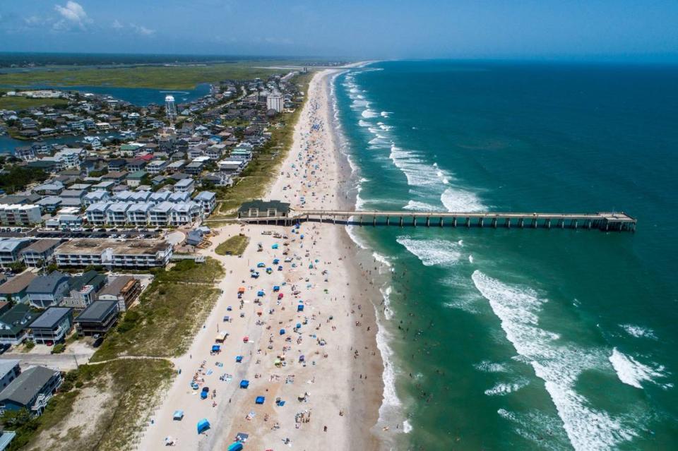
Alternate routes to the Wilmington area
These days, getting to the Wilmington area of North Carolina — we’ll include Wrightsville Beach, Carolina Beach and Kure Beach here, among other spots, for grouping’s sake — from the Triangle is a relatively quick and straight shot down I-40.
But it wasn’t always that way. Yes, there was life before I-40.
I-40 wasn’t completed in North Carolina until 1990, and before then, people used other common routes — namely U.S. 421 — to get to the Wilmington area. If you’re looking to step back in time to beach trips of the past, this might be the route for you.
▪ In North Carolina, U.S. 421 runs from Watauga County in the mountains to Fort Fisher, near Kure Beach.
▪ Depending on where in the Triangle you’re coming from, you can pick up U.S. 421 near Sanford.
▪ The route will take you through Lillington, Dunn and Clinton, among other towns.
Depending on where you’re starting your trip, other alternate routes to the Wilmington area include:
▪ N.C. Highway 87, which will take you through Fayetteville.
▪ U.S. 117, which runs parallel to I-40 beginning around the Mount Olive area. Recommended Pit-Stop: Stop by Paul’s Place in Rocky Point, about 20 miles from Wilmington, for some of North Carolina’s most famous hot dogs and sweet relish.
Alternate routes to the Crystal Coast
If you’re headed to North Carolina’s southern Outer Banks — also known as the Crystal Coast, including Atlantic Beach, Emerald Isle and Pine Knoll Shores, among other locales — the quickest route from the Triangle is to generally via U.S. Highway 70 after a short stint on I-40.
Alternate routes to the Crystal Coast from the Triangle include:
▪ U.S. 264 to N.C. 58 to U.S. 70, which will take you through Snow Hill, among other spots.
▪ If you want to experience parts of all of the routes, you can start out on U.S. 264, then take I-795 down to join U.S. 70 around Goldsboro. Recommended Pit-Stop: If you’re looking for attractions on this conventional route, try stopping off at one of the barbecue restaurants along the way, from Wilber’s Barbecue in Goldsboro to Kings Restaurant in Kinston and so many more.

Alternate routes to the Outer Banks
If you’re heading to the Outer Banks from the Triangle, most map apps will suggest you take U.S. 64, which runs from the Tennessee state line to the coast, after short stints on different interstates, depending on exactly where you’re starting your trip.
▪ The route will take you through Rocky Mount, Tarboro, Plymouth and other towns before you head north or south on the famed N.C. Highway 12, depending on your final destination on the Outer Banks.
Possible alternate routes to the Outer Banks depend on your intended final destination.
▪ If you’re headed to the northern part of the Outer Banks, such as Nags Head, Kitty Hawk or Kill Devil Hills, you can take Interstate 85 from the Triangle and head north into Virginia, where you’ll take U.S. 58 to the Hampton Roads region before heading back south to North Carolina on N.C. 168.
▪ If you’re heading farther south on the Outer Banks to Ocracoke, instead of taking U.S. 64, you could follow the routes mentioned above for Atlantic Beach — taking U.S. 70 for most of the way. Remember: Ocracoke is only reachable by boat or ferry, so roads will only take you so far, no matter which route you take.

