
 Yahoo Movies
 Fresno City Council adopts new voter district boundaries. Will political power shift?
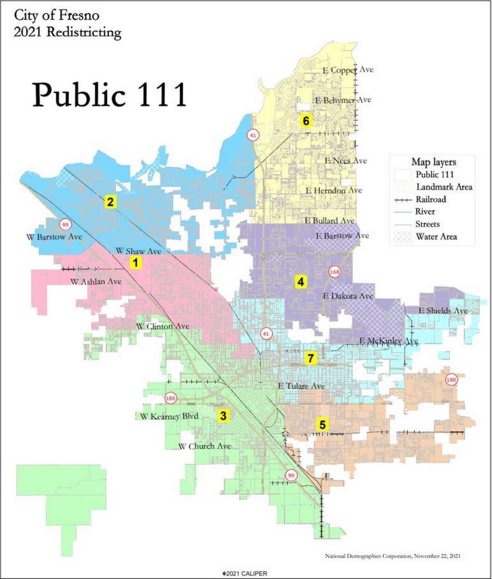
The Fresno City Council on Thursday night advanced a new council district boundary map for adoption that councilmembers said they believe will recognize historic neighborhoods, unite Highway City, eliminate land-locked districts, and comply with federal, state, and city laws.
The new boundaries were approved by a 6-0 vote. Councilmember Esmeralda Soria, who joined the meeting virtually via Zoom, did not vote. The final vote will be conducted Dec. 9. The council could have advanced more than one map for the final vote on Dec. 9 but didn’t.
The councilmembers approved map Public 111 after extensive public comment from Punjabi community members voicing support for two other maps. Some Tower District residents also expressed concern that the proposed map would further split up the neighborhood. City officials said the maps backed by community members did not meet city charter regulations.
Map Public 111 extends the previously landlocked District 7 to the eastern city limit and into a small part of the Tower District on the western edge. It also unites Highway City and maintains the three Latino majority districts as state law mandates.
While Soria said she didn’t support map Public 111, she also said she was proud of the process.
“I’m proud tonight that so many people turned out — that you guys came to a realization that representation matters,” Soria said. “It only makes our democracy stronger when we all get involved from the beginning, from the drawing of the lines, all the way to when elections take place.”
Fresno Inclusive Families Map
Most residents who spoke out Thursday backed a map submitted by a diverse coalition of community groups called the Fresno Inclusive Families Map. The map largely followed school boundaries and aimed to keep underrepresented communities, such as the Black, Hmong, Muslim, and Punjabi communities, whole.
“Our map was created with the sole intention of doing what is best for our city that has so many urgent needs,” said Pedro Navarro Cruz, a community organizer with the Communities for a New California Education Fund.
“While it’s impossible to have a perfect map, the Inclusive Families Map has minimal splitting and fingers that divide neighborhoods throughout the city,” Navarro Cruz said.
Many community members also expressed support for Public 108.
But councilmembers and city consultants said those maps didn’t meet city charter requirements because the city charter required no councilmember be drawn out of their district.
“The Council calls for public input, but I think a lot of people today just have the question: how much do they listen?” said Naindeep Singh, executive director of the Jakara Movement.
Before the vote, Councilmember Miguel Arias tried to reassure the Punjabi community.
“I also want to assure you that the Punjabi community that’s here today, we all recognize and value all of you,” Arias said. “I think all of us here have been to the Sikh temple on Ashlan, and we’re constantly engaged with your community — with all our diverse communities.”
