
 Yahoo Movies
 Flooding others in Tulare Lake basin ‘premeditated’ by Boswell, one farmer asserts
By the time Erik Hansen had a moment to sit down in a Corcoran pizza parlor on a recent afternoon, the fifth-generation farmer was tired, detached and a little defeated looking.
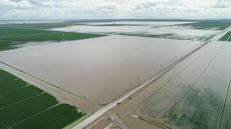
He talked matter-of-factly of his family’s losses so far: At least 3,000 acres are under water, some orchards will die, his cousin’s house is destroyed and his own family had to evacuate to his dad’s place in Visalia.
“It’s devastating,” he said. “We’ve spent the last 10 days, or however long, trying to get things out of our houses, equipment out of the shop. We’re trying to save the shop now but I doubt we will.”
And more water is coming with the snow melt, he said.
Based on his memories of the 1982-83 flood, he anticipated water would remain on the land for possibly a year.
Back then, though, “It didn’t flood on that side,” he said, referring to lands south and east of Corcoran, where his family ranch looks like a vast ocean with a lone metal shed holding vigil against the waves.
Anger toward Boswell at Kings County supervisors meeting
Flooding over miles of farmland north and east of the old Tulare Lake bed has sparked questions and angry accusations by farmers against one of the area’s biggest farming operations, the J.G. Boswell Company.
Hansen didn’t want to talk about Boswell in the pizza parlor, but he and his brother Phil Hansen pulled no punches at a special meeting of the Kings County Board of Supervisors on March 18.
“In my opinion, this was premeditated by Boswell,” Phil Hansen told supervisors. “They flooded El Rico first and they knew it wouldn’t hold back the water and that it would break on us. And they kept it all hush hush.” El Rico is one section of the 132,000 acres owned by Boswell that cover the old Tulare Lake bed.
Boswell representatives at the meeting said their focus has been to protect the town of Corcoran by keeping room in the old Tulare Lake bed for expected higher flows. That’s “ridiculous,” Hansen said.
If the massive lakebed had filled so much that it threatened Corcoran, then farmland to the southeast would have been open to absorb the overflow at that point, not first.
As of Thursday, March 23, the area west of El Rico in the lake bottom was still dry. Kings County Supervisor Doug Verboon said it was his understanding that section was being “saved” for Kings River water. A Boswell Company representative did not return phone calls.
The Hansens and others at that March 18 meeting and elsewhere have said Boswell ignored a time-honored flood management process to fill the lowest part of the lake first. That allows rivers and streams to flow freely for longer, minimizing damage to upstream areas. Instead, critics have said, the company tried to hold water off the lowest part of the lake, opting to fill spaces around the edges first.
“We know we’re in a huge flood,” Phil Hansen said March 18. “And those areas would have flooded anyway.” But filling the lake from the bottom up would have given people more time to protect their homes and move belongings and livestock out of harm’s way.
Instead, farmers dealt with a cascade of breaches in river banks and canals north and east of the lakebed that had never broken before. The fast-moving water was stalled at the lake, they said, it backed up on itself and flooded thousands of acres.
Flood risks known to all, Boswell president says
“We understood when this all started and water started spilling out of the river’s natural banks,” dairyman Brandon Dykstra told SJV Water. Dykstra’s property is about 10 miles northeast of Corcoran just north of the Tule River. “But we thought it would keep flowing to the west.”
Instead, the water just kept rising.
“Every day and night was a battle trying to save field after field. We worked all night to build one wall and when it broke, I had to leave. I couldn’t be on the farm for a while,” Dykstra said. “There’s just a lot of confusion about why this happened here.”
He didn’t lose any cattle but lost crops and is in a scramble with other dairy owners to find enough feed as the flood has destroyed thousands upon thousands of acres of feed crops.
Jace VanderHam, who was busy moving his cattle and helping other dairy owners find dry spaces for their animals, said he doesn’t want to point fingers. He just wants to know what happened and why.
“I’ve talked to some big farmers, really big farmers, and no one wants to pick fights. We all just want to know what’s going on.”
Boswell representatives at the March 18 meeting defended the company’s actions saying the area east of Corcoran is, or should be, a known flood risk area.
“It’s not like we blindsided them (the Hansens),” said George Wurzel, president and chief operating officer for Boswell. “They get all the same information we do at meetings. They knew it was a threat.
“Hell, even Lois Henry knows it’s a threat. This isn’t a mystery.”
Wurzel was apparently referring to SJV Water’s numerous articles about subsidence from groundwater pumping east of Corcoran that has altered flood plains in that area, according to a high-speed rail engineering report.
‘Politics over physics,’ one farmer accuses
Regardless of subsidence, farmers at the March 18 meeting pointed to the basic geography at play. The lake bed is the lowest spot in the county, they noted.
“You can’t fill a bucket from the top down,” said farmer Jim Verboon, a cousin to Supervisor Doug Verboon. “You’re trying to use politics over physics.”
Dominic Sween, a Boswell engineer, argued bluntly against county intervention on Boswell lands.
“If this was your property and you raised levees to protect yourself and someone else came in and said your lands need to be flooded just because, how would you feel?” he asked. “That’s part of our perspective.”
Phil Hansen said the Boswell company did exactly that by choosing to keep its ground dry at the expense of other landowners.
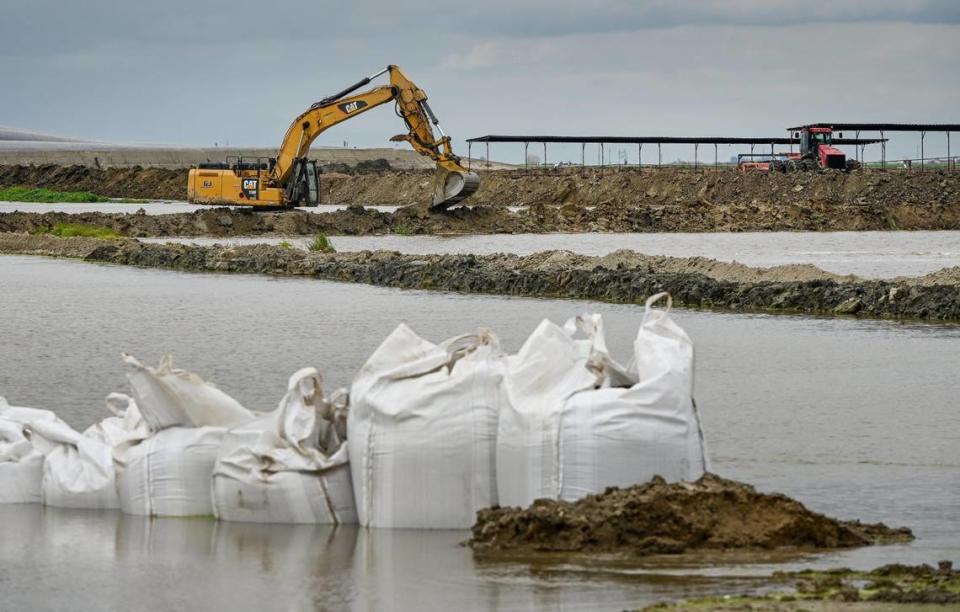
Supervisors had already voted at a special meeting held Friday March 17 to cut a levee in the lake bottom known as 749. That levee is south of the Tule River and holds water back from the lowest spot on the lakebed.
But later that day, Boswell contacted Supervisor Verboon to argue against cutting 749. In the interest of hearing all sides, Verboon told SJV Water, he called for a pause on cutting the levee and supervisors scheduled the March 18 meeting.
Supervisors ultimately upheld their original order and levee 749 was cut on the afternoon of March 18.
A lull in crisis, but a Boswell canal remains dry
Since then, storms have tapered off and water has receded slightly.
But dairies and homes across Kings County continued to be evacuated through the weekend. Tulare County Sheriff Mike Boudreaux extended evacuation orders to cover vast swaths of farmland northwest of Alpaugh, noting crews were dealing with 55 different river breaches.
Despite the lakebed now taking some water, farmers reported that one of Boswell’s main canals, the Homeland, remained shut off from taking Tule River water.
“It looks like they’re trying to move a lot of water through a small channel and it’s flooding out other farmers,” Dykstra said. “But not knowing what’s happening and seeing all this flooding around us…it’s really frustrating.”
SJV Water is an independent, nonprofit news site dedicated to covering water issues in the San Joaquin Valley.

