
 Yahoo Movies
 Fact check: Viral image misrepresents the electoral process
The claim: There are no blue states, only blue cities
A viral image circulating on social media is promoting a misleading representation of the U.S. electorate. The image shows a red and blue map of the country with the words “There are zero blue states only blue cities,” across the top.
One July 25 Facebook post with the image reads, “so how did communist tyranny take over?”
Former U.S. Rep. Tom Tancredo, R-Colo., shared the image to Facebook on July 26.
Fact check: Conspiracy theory falsely says Biden arrested in plot to make Trump president
But this image is inaccurate in several ways. It pushes a misleading idea of how elections are determined, misrepresents counties as cities and shows outdated election results.
USA TODAY reached out to several users for comment.
County map doesn’t represent election results
Barry Burden, director of the Elections Research Center and professor of political science at the University of Wisconsin-Madison, told USA TODAY the image was misleading.
“Because elections are decided by the votes of actual people rather than the land represented by county borders, it is incorrect to conclude that a state is ‘red’ or ‘blue’ because most of the counties in that state are of the same color,” he wrote in an email. “Many counties in the U.S. have extremely small populations that do not contribute much to the statewide result.”

The concept of “red states” and “blue states” comes from television news graphics. NBC introduced the idea in a 1976 broadcast in which election night anchor John Chancellor projected which states would vote for each party. Originally, blue was used for states that would vote Republican, and red was used for those projected to vote Democrat.
Fact check: Biden CNN town hall crowd smaller than Trump Phoenix speech because it was invite-only
Today, blue states are understood as those where most of the population usually vote for Democrats and red states are those where most voters prefer Republicans.
Electoral slates are determined by population
The Facebook post's focus on a map with more red than blue implies each section of the map should be given equal weight, but electoral power in the U.S. is determined by population, not land mass.
States are awarded electoral votes based on their population as measured in the last Census. Each state’s electoral slate is equal to the state’s total number of congressional representatives (two senators and the number of representatives the state has in the House).
This is part of the U.S. system of proportional representation called for by the Constitution. At the Constitutional Convention of 1787, the founders reached the “Great Compromise” by which the American legislature includes a House, with membership determined by state population, and a Senate, in which each state has equal representation.

Map is outdated and misleading
The map in the viral image also misleads because it shows counties while the text addresses cities.
According to Burden, the results in the map also do not appear to show results from any of the last four presidential elections.
Fact check: False claim persists online that Trump will be reinstated as president in August
USA TODAY created a map of the 2020 county-level election results that showed counties in nearly every state voted across the political spectrum. The map below shows votes by county as circles, weighted by the number of voters in each, which provides a more accurate view of how Democratics tend to attract voters who are more clustered together in cities while Republicans dominate rural areas.
In some states, including Massachusetts, Rhode Island and Hawaii, the majority vote in all counties went to Biden.
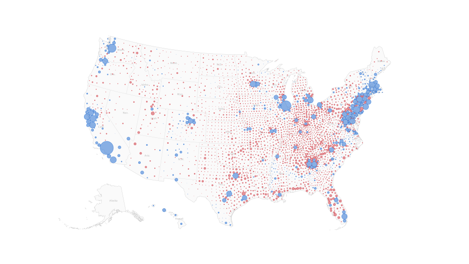
Burden said such maps that consider population distribution offer much stronger insight into election results.
“Every state is a mixture of Democratic and Republican votes,” he said.
Our rating: False
Based on our research, we rate the claim that there are no blue states, only blue cities FALSE. Elections are determined in the Electoral Collage by the state's total votes – not which candidate wins the most counties or has votes spread over the largest area.
Our fact-check sources:
Barry Burden, July 28, email correspondence with USA TODAY
NPR, Nov. 13, 2014, The Color Of Politics: How Did Red And Blue States Come To Be?
Cambridge Dictionary, accessed July 28, blue state
Cambridge Dictionary, accessed July 28, red state
The House Committee on the Budget, Jan. 31, 2019, These Are Our Numbers – The Importance of the 2020 Census
United States House of Representatives, accessed July 28, History, Art & Archives Proportional Representation
USA TODAY, Nov. 10, 2020, Four maps that show how America voted in the 2020 election with results by county, number of voters
USA TODAY, Nov. 3, 2020, 2020 Massachusetts Election Results
USA TODAY, Nov. 3, 2020, 2020 Rhode Island Election Results
USA TODAY, Nov. 3, 2020, 2020 Hawaii Election Results
Wired, June 27, 2018, Is the US Leaning Red or Blue? It All Depends on Your Map
Thank you for supporting our journalism. You can subscribe to our print edition, ad-free app or electronic newspaper replica here.
Our fact-check work is supported in part by a grant from Facebook.
This article originally appeared on USA TODAY: Fact check: False claim the U.S. doesn't have any blue states

