
 Yahoo Movies
 Depression could turn into Tropical Storm Bill, forecasters say. Other systems brewing
Tropical Depression Two, which formed off the coast of North Carolina Monday morning, is forecast to turn into Tropical Storm Bill as it moves away from the United States, according to the National Hurricane Center.
If it does strengthen into Bill, as is expected, it would be the second named storm of the season. Subtropical Storm Ana formed near Bermuda last month — making it the seventh year in a row that a named storm formed before the hurricane season’s official start date, June 1.
Forecasters are also watching a new tropical wave that emerged just offshore of west Africa early Monday. A disturbance in the Gulf of Mexico is also forecast to turn into a depression later this week.
Meanwhile, parts of South Florida got soaked Monday and could see some more rain Tuesday. By 6 p.m., about less than an inch fell both at Miami International Airport and Fort Lauderdale-Hollywood International Airport, according to the National Weather Service in Miami.
Monday’s storms also brought strong wind gusts across the region, NWS meteorologist Robert Garcia said. There were gusts up to 75 mph in Broward. More storms were expected Monday night in South Miami-Dade and Monroe County — where there is a severe weather advisory.
“It still looks like this unsettled pattern is going to continue,” Garcia said. “Maybe not be consistent, but there still can be some ponding of water.”
The rain chance for Tuesday is 60 to 70 percent, Garcia said.

Here’s what to know:
Tropical Depression 2: Where is it going? Will it turn into Bill?
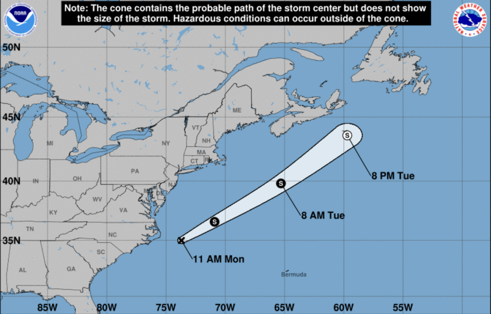
The National Hurricane Center announced the formation of Tropical Depression 2 around 10 a.m. Monday.
The system was moving northeast, away from the United States, near 18 mph with maximum sustained winds of 35 mph and higher gusts, as of the hurricane center’s 5 p.m. Monday advisory. It was about 200 miles east of Cape Hatteras, N.C.
Forecasters expect it will strengthen into a tropical storm Monday night and will see some additional strengthening on Tuesday before it moves into colder waters and begins to weaken. It should dissipate on Wednesday near Newfoundland.
NHC will initiate advisories on Tropical Depression Two, located offshore of the coast of North Carolina and moving away from the United States, at 1100 AM EDT (1500 UTC).
— National Hurricane Center (@NHC_Atlantic) June 14, 2021
There’s a disturbance in the Gulf of Mexico. What’s the forecast?
Forecasters are also watching a disturbance in the Gulf that was producing showers and thunderstorms over the Bay of Campeche. It’s forecast to meander near the coast of Mexico during the next few days and will likely turn into a tropical depression later in the week once it moves across the central or northwestern Gulf of Mexico.
It has a 20% chance of formation in the next 48 hours and a 70% chance through the next five days.
“Regardless of development, heavy rainfall is possible over portions of Central America and southern Mexico during the next several days. Heavy rains could also begin to impact portions of the northern Gulf Coast on Friday,” forecasters wrote.
What about the tropical wave in the Atlantic?
Forecasters are also monitoring a strong tropical wave that was about several hundred miles south-southeast of the Cabo Verde Islands, as of 2 p.m. Monday.
The system is maintaining a large but disorganized area of showers and thunderstorms and could see some development during the next few days, according to the hurricane center.
However, a combination of dry air and strong upper-level winds should reduce the wave’s chances of strengthening as it moves into the central Atlantic later this week, according to the hurricane center. It has a 10 to 20% chance of formation in the next two to five days.
Miami Herald staff writer Carli Teproff contributed to this report.

