
 Yahoo Movies
 Are there disease-carrying ticks in your county? This interactive map can show you
Lodged in small plastic bags — dead or alive — more than 21,000 ticks were mailed by nature aficionados to the Bay Area Lyme Foundation in California over three years in an attempt to better understand where the disease-carrying critters live in the U.S.
Beginning in 2016, the citizen science project tested the ticks for four of the most common bacterial infections that make people sick, including those that cause Lyme disease, tick-borne relapsing fever, human granulocytic anaplasmosis (HGA) and babesiosis, a malaria-like disease.
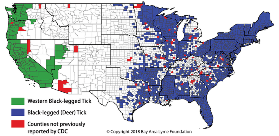
Testing revealed that ticks carrying any one of these diseases are living in 83 counties across 24 states that the Centers for Disease Control and Prevention had not previously identified to host these arachnids. States with newly documented disease-carrying ticks include Alabama, Georgia, Illinois, Kansas, Louisiana, Minnesota, Texas, Utah, Washington, Kentucky and the Carolinas, among others.
The project also found that ticks carrying the bacteria that cause Lyme disease live in 116 counties the CDC has yet to flag.
The team developed an interactive map that you can use to check whether disease-carrying ticks live in your county, including the Western blacklegged tick, blacklegged tick, American dog tick and lone star tick.

Ticks were sent in from 49 states, excluding Alaska. Puerto Rico was not involved in the study. People did not submit ticks in counties colored white on the map, but researchers say those areas could still carry some risks, especially if nearby counties are colorful.
Initial data was published in January in the journal PLOS One, followed by an update in September in the journal mSphere.
“These maps will be eye-opening for many Americans as it makes it easy to see that ticks carrying disease-causing bacteria can be commonly found across the U.S.,” study lead author Tanner Porter, a research associate at the Translational Genomics Research Institute, said in a news release. “If you aren’t aware of the possibility of ticks, either in your backyard or while traveling, you are unlikely to look for them.
“But an unseen tick can still transmit a pathogen and cause disease,” Porter continued. “It is important for everyone to know to look for ticks, be aware of the pathogens that they carry, and take steps to mitigate their risk.”
Normally, researchers would drag a large sheet-like material across the ground that ticks latch onto to collect data, but the contributions of people who sent the critters to the Bay Area Lyme Foundation — a nonprofit working on the prevention and treatment of Lyme disease — helped a ton, according to the group.
Otherwise, the research would have required 30 years of data collection. Other institutions involved in the research include Northern Arizona University, Colorado State University and the Translational Genomics Research Institute in Arizona.
Researchers say a citizen science approach “allows for real-time distribution monitoring of ticks and other relevant species, an important consideration with emerging pathogens, changing land-use patterns, and climate change.”

