
 Yahoo Movies
 Cross-country storm to bring more severe weather, tornado threat
Areas pummeled by last week's deadly tornado outbreak are likely to see more severe weather in the coming days as a cross-country storm moves east, bringing with it the threat of long-track tornadoes.
As of Thursday morning, 27 states and nearly 30 million people were on alert for heavy snow, strong winds or flooding from California to Wisconsin.

A major storm that battered the West Coast will move into the Heartland on Friday, with a major severe weather outbreak expected.

The storm already brought up to 30 inches of snow to Mammoth Lakes, California, in a 24-hour period. The area has seen more than 700 inches of snow this season -- making for its snowiest winter on record. Some flooding, hail and even mudslides were also reported across California from the Bay Area to Los Angeles County.
The storm is forecast to leave California later Thursday and will cross the Rocky Mountains overnight, bringing heavy snow to the area. Wind gusts up to 75 mph from Arizona to Colorado are also forecast in the next 24 hours.
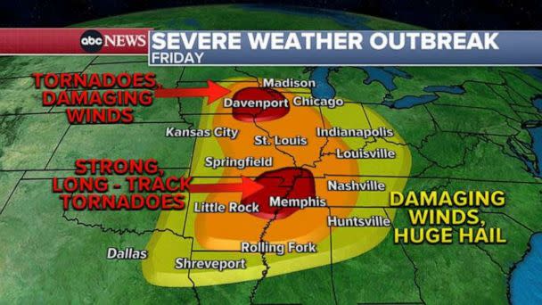
By Friday, the storm is expected to redevelop in the Plains and produce a major severe weather outbreak from Texas to Wisconsin. Some 70 million people are on alert Friday for the risk of severe thunderstorms.
"Strong, potentially long-track tornadoes, large hail, and numerous damaging gusts are all possible," the National Weather Service said.
The highest threat for strong, long-track tornadoes will be near Memphis, Tennessee, while the Iowa/Illinois border is more likely to see damaging winds and large hail.
MORE: EF4 tornado devastates Mississippi city: What to know about the EF scale
In addition to tornadoes, damaging winds and huge hail could be possible in Des Moines, Iowa; Chicago; Indianapolis; Nashville, Tennessee; and Little Rock, Arkansas.
Severe weather could reach as far south as Rolling Fork and Silver Springs, Mississippi, which were devastated by a deadly tornado outbreak last week.
MORE: Tornado destruction highlights low-income disaster preparedness challenges
To the north, snow and ice is a concern for much of the northern Plains and Upper Midwest due to the cold side of this storm.
In parts of South Dakota and western Minnesota, there may be a foot or more of snowfall. Gusty winds will also reduce visibility, leading to a blizzard potential for a portion of South Dakota, where there are currently blizzard warnings in effect. Winter alerts are already in effect for the snow potential and the subsequent travel impacts.

As this storm moves eastward, it is expected to bring two bands of rainfall to the Northeast -- one on Friday during the day, and another early Saturday morning.
Some in the Northeast may also see 1 to 2 inches of rain on both Friday and Saturday.
Gusty winds may also lead to scattered power outages on Friday and Saturday, with wind alerts currently in effect for more than 30 million people across the country.
Cross-country storm to bring more severe weather, tornado threat originally appeared on abcnews.go.com
