
 Yahoo Movies
 Picture becoming clearer for impressive storm threatening Central Canada
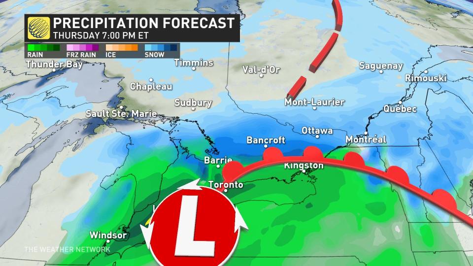
Ontario and Quebec are facing a winter storm threat that could dump heavy snow and rain across the provinces later in the week.
A Colorado low will develop Wednesday night and track northeast towards Ontario and Quebec. This, and a secondary system, will merge by the time they reach southern Quebec, leaving a snowy trail Wednesday night and through Thursday.

While there is still some uncertainty about how exactly the system will develop and where it will track, there is growing confidence that there will be a large swath of heavy snow and rain impacting both Ontario and Quebec.
Highway 401 is a good dividing line for the storm as heavier, accumulating snowfall will most likely fall north of the highway, and wet snow and rainfall is likely to the south.
WATCH: Shredding up the hill at Glen Eden ski resort
Warmer conditions will allow for most of the precipitation to initially fall as rain before transitioning to snow as the Colorado low moves into Ontario.

There is the potential for upwards of 15-30+ cm of snow to fall in areas seeing the heaviest snowfall and 15-30 mm for areas seeing the heaviest rainfall. Peak precipitation amounts are expected to occur between Thursday and Friday. We have high confidence that Ottawa will see upwards of 30 cm of snowfall out of this current storm track.
Currently, it looks like areas along lakes Ontario and Erie will experience higher odds for more rainfall, while areas farther north, including Georgian Bay, are likely to recieve very significant snowfall.
This outlook, however, can be subject to change as it’s still early on in the forecast, but confidence is growing in how the system will behave.
Thumbnail courtesy of Shutterstock.
For more updates and forecast information, keep checking back to The Weather Network.

