
 Yahoo Movies
 ‘Catastrophic’ Ian Makes Landfall in Florida as One of the Most Powerful Hurricanes Ever
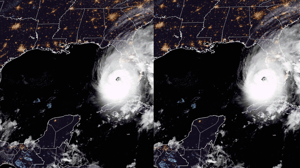
Storm surge from Hurricane Ian began inundating several cities on the Southwest Florida coast on Wednesday afternoon, sweeping some homes off their foundations as it simultaneously pounded Florida with 155 mph winds.
Winds at that speed are the equivalent of an EF3 tornado, meteorologist Matthew Cappucci reported, and are expected to span at least 50 miles as Ian—the strongest storm of the season and one of the most powerful in history—wallops Florida.
While the whipping winds are a serious threat, the National Hurricane Center says that “catastrophic” storm surge of 18 feet—enough to inundate some small homes completely—could also be deadly between Sarasota and Fort Myers, where Ian made landfall just after 3 p.m.
“That is a tremendous amount of water,” Ross Giarratana, a meteorologist at the National Weather Service’s Tampa Bay office, told The Daily Beast. “Not something you want to ride this out in.”
By 2 p.m. Wednesday, videos emerged from Naples and Fort Myers Beach that showed both cities partially submerged, overcome by a storm surge of more than 6 feet—hours before high tide is expected. Videos appeared to show homes floating in the surge there.
In another video, a house in Naples had its roof ripped off by Ian’s winds, which have forced local first responders to stop responding to all calls as far north as Sarasota County.
One of my friends just sent me this from #Naples. #Hurricane pic.twitter.com/XJBgdz2N0O
— Dave Epstein (@growingwisdom) September 28, 2022
Florida Power & Light, which services much of Southwest Florida, reported just after 4 p.m. that more than 500,000 residences were without power, which is about a third of the population of Sarasota, Charlotte, Lee, and Collier counties. A spokesperson told ABC 7 that customers should prepare for significant delays in getting power back as Ian's strength may mean the company has to “rebuild parts of their system, not just restore power.”
To the north, in Pinellas County, Duke Energy reported 35,000 people were without power at 2 p.m.—hours before Ian is expected to deliver hurricane-level winds there.
Making things direr for those directly in Ian’s path is the suddenness of the threat.
Southwest Florida was initially forecast to avoid the worst of the tropical system for the last week. Ian was instead forecast over the weekend to strike north of Tampa Bay, followed by a forecast on Monday that had Ian striking Tampa Bay itself—90 miles north of where Ian is headed onshore Wednesday morning. But Ian’s path slowly crept east, followed by one last significant shift on Tuesday night that suddenly put the southern half of Florida’s Gulf Coast directly in harm’s way.
Perhaps because of this late shift, most of the shelters in Sarasota and Manatee counties remained empty on Wednesday morning, the Sarasota Herald-Tribune reported.
Widespread surge flooding of homes is underway in #Naples #FLwx as #Ian roars inland.
Tide gauge currently showing ~6.25 feet of surge. Water could come up another several feet this afternoon.
Webcam via https://t.co/h53cce4CDV pic.twitter.com/RVL2pddUgK— Jack Sillin (@JackSillin) September 28, 2022
This could be a dangerous combination for the nearly 2 million people who live between Sarasota and Fort Myers. Meteorologists have likened the path and strength of Ian to that of Hurricane Charley, which killed 35 and caused $25 million in damages when it struck the same area in 2004.
But while Southwest Florida will suffer the brunt of Ian’s force, most of Florida will face dangerous conditions in the next 36 hours.
In Tampa Bay, the largest threat is excessive rainfall—with isolated pockets that could see 24 inches fall, while most get at least 18 inches—in a region that regularly floods with significantly less rain. Similar totals are expected in Orlando and Daytona Beach as Ian moves across the state, parallel with Interstate-4.
All of Florida, meanwhile, is at risk of tornadoes spawning in Ian’s outer rainbands, the National Weather Service said. The storm already showed what it was capable of on Tuesday night, when a tornado is suspected of flipping and demolishing small aircraft at an airport in Broward County, and when the streets of Key West were completely flooded despite Ian missing to the west.
Breaking: Photos coming in from North Perry Airport in Hollywood, where a possible Tornado touched down. @NWSMiami pic.twitter.com/rhfbfPWWMw
— Total Traffic Miami (@TotalTrafficMIA) September 28, 2022
In an eerie sign of what’s to come, pictures emerged Wednesday of the bay just outside downtown Tampa—usually full of glistening blue water—gone completely barren, sucked out to sea by Ian.
DOWN BY THE BAY 🌊: Check out this 𝒊𝒏𝒄𝒓𝒆𝒅𝒊𝒃𝒍𝒆 view of #BayshoreBlvd taken by one our TampaPD Lieutenants! The water has receded, a clear sign that #hurricaneian is drawing near. 𝗥𝗘𝗠𝗘𝗠𝗕𝗘𝗥: Evacuations are still in effect for Zones A and B #YourTampaPD pic.twitter.com/fLhTkNuHtz
— TampaPD (@TampaPD) September 28, 2022
The water is expected to come back with vengeance later Wednesday, however. This has kept thousands of residents in Tampa and the surrounding areas in mandatory evacuation zones, with local authorities warning that first responders won’t be sent to save anyone who chooses not to evacuate.
“All information tells us this is very serious,” said Pinellas County Sheriff Bob Gualtieri on Monday. “This is the real deal. If you don't evacuate, you're on your own. No one's going to come to rescue you.”
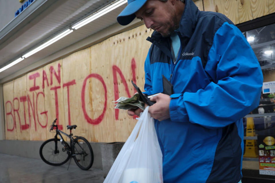
Shoppers collect last minute supplies in Tampa.
Florida’s gulf coast began shutting down Monday, with school districts canceling classes for the week, while the airports and grocery stores in the region closed up shop by Tuesday evening. Even the Hillsborough County Jail was evacuated on Wednesday morning, transporting 160 inmates farther inland just before Ian’s arrival.
8:45 pm at pier off White Street in Key West. I didn’t take this, a friend sent it to me. pic.twitter.com/ofugIOyNac
— Gwen Filosa (@KeyWestGwen) September 28, 2022
And Waffle House, often the last business to close and regularly the barometer of just how serious a storm is, told USA Today on Wednesday morning that it would close 21 locations in Southwest Florida.
Florida Gov. Ron DeSantis, who spoke with President Joe Biden on Tuesday about the impending storm, begged residents to heed evacuation orders and treat the system as a serious threat.
“It’s time to hunker down and prepare for this storm,” he said in a press conference Tuesday. “This one is the real deal... This storm is going to do a lot of damage, so people should be prepared for that.”
Get the Daily Beast's biggest scoops and scandals delivered right to your inbox. Sign up now.
Stay informed and gain unlimited access to the Daily Beast's unmatched reporting. Subscribe now.

