
 Yahoo Movies
 B.C. faces the driest conditions in North America despite La Niña
It’s been hard to find meaningful precipitation across British Columbia for the past couple of months.
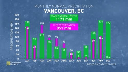
In fact, it’s been six long months since Vancouver has recorded a month with above-average precipitation. The atmospheric taps seemingly turned off after an unusually wet June, and we’ve faced a persistent drought across southern B.C. since the heart of the summer.
DON’T MISS: New state of emergency in B.C. sparked by ongoing drought
Even though the pattern briefly broke to give us a stretch of unsettled weather toward the end of October, conditions snapped right back to the status quo and squashed all dreams of a consistent storm track across the region.
Why has it been so dry for so long? The polar jet stream is responsible for bringing stormy conditions to the South Coast. The track of the jet usually dives south across the South Coast toward the western United States, allowing one storm after another to keep the region well-watered.
That hasn’t happened this year.

Recently, the polar jet stream has arced over Alaska instead, building a significant ridge and record-breaking warmth over the state. This disruption in the jet stream also disrupted the storm track, keeping B.C. unusually dry for months on end.
This season’s ongoing La Niña would normally favour a wetter pattern across B.C., but the current pattern is bucking that trend.
This year, sea surface temperatures across the North Pacific have warmed with significant high pressure over the region, while the ridge has moved closer to the coast. These two factors forced most of the region’s storms to arrive from the moisture-starved northwest rather than tapping into rich moisture from the south.
Looking at the long range pattern, the most anomalously dry place in North America is the coast of British Columbia.

Vancouver typically records 170 mm of precipitation in December, and we’ll have an uphill battle finding half as much this month under the current pattern. Most of the rain will sink far south and fall over California instead.
MUST SEE: Seven times weather unexpectedly changed the course of history
Water shortages and conservation efforts are ongoing across Vancouver Island as Mount Washington opens on December 9th.
Snow data from the B.C. government shows the province’s lowest average snowpack is over Vancouver Island at just 42 percent, with some local water and snowpack data showing conditions at just 25 percent of normal. Given the stark situation across the region, it’s no surprise that river flows are the lowest on record for early December.
Things are better across the rest of B.C., though—as a whole, the provincial average snowpack is sitting just a hair above normal.

