
 Yahoo Movies
 70-mph winds slam mountains, 63,000 lose power. Hot temps soon for Charlotte, Raleigh.
Wind gusts up to 70 mph slammed parts of the North Carolina mountains, and 63,000 Duke Energy customers in the Carolinas remained without power at 6 p.m. Saturday after a line of thunderstorms raced in from Georgia in the pre-dawn hours.
Storms delayed flights, including at least 504 by 7 p.m. at Charlotte Douglas International Airport, according to tracking site FlightAware.com. At least 280 departures and 224 inbound planes were delayed at the American Airlines hub.
At Raleigh-Durham International Airport, at least 97 flights were delayed by 7 p.m., including 53 departures and 44 inbound, FlightAware.com reported.
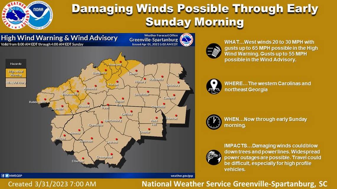
“Gusty winds will continue for the remainder of Saturday,” meteorologist Jeffrey Taylor of the NWS office in Greer, South Carolina, told The Charlotte Observer at 8:30 a.m.
Taylor said no damage had been reported.
NWS forecasters predicted gusts as high as 37 mph for Charlotte throughout Saturday, 44 mph for Raleigh, 33 mph for Rock Hill and 46 mph for Asheville.
In Raleigh, the start of the Dreamville music festival was delayed two hours because of the risk of high winds. The gates, originally scheduled to open at noon, opened at 2 p.m.
Just after sunrise Saturday, at least 4,000 customers remained without power from the storms, nearly 3,000 of them in areas near Raleigh, including Knightdale and Zebulon, the Duke Energy outage map showed.
By 8:30 a.m., the number of customers without electricity dropped to around 1,500, many of those in Bryson City and near the Eastern Band of Cherokee Indians’ Qualla Boundary in the mountains, according to the map.
Outages then climbed again. At 9:30 a.m., 4,200 N.C. customers had no electricity, including 1,000 in Asheville.
Winds picked up again Saturday afternoon, knocking power out to 25,000 Asheville-area customers and another 5,000 in the Robbinsville area farther west, the Duke Energy map showed.
At 5:30 a.m. Saturday, the NWS Greer office issued a wind advisory for the Charlotte area, mountains, Upstate South Carolina and the N.C. Foothills until midnight.
“Gusty winds could blow around unsecured objects,” meteorologists said in the advisory. “Tree limbs could be blown down and a few power outages may result.”
The NWS warned mountain residents and visitors to “avoid being outside in forested areas and around trees and branches.”
Hot temps on the way
A cold front ushered in Saturday’s storms and winds, according to the NWS.
Just as quickly, temperatures are expected to rise across the state through much of the work week, according to the 10 a.m. Saturday NWS forecasts for Charlotte, Raleigh and Rock Hill.
From a predicted high of 79 Saturday, Charlotte’s high on Sunday is expected to fall to 68, the forecast showed. Highs are then expected to climb to 70 Monday, 80 Tuesday and 86 Wednesday, April 5.
The record high in Charlotte for April 5 is 88 degrees, set in 1942, Taylor said.
Skies in Charlotte should remain mostly cloudy through the week.
Highs in Charlotte are forecast to drop again, from 80 Thursday to 65 Friday.
A high of 86 also is predicted Wednesday for Rock Hill, and 85 in Raleigh.

