Yahoo Movies
 A new $35 million storm basin could have eased Merced’s flooding. But it’s not built yet
It’s been more than two years since Merced County was awarded almost $10 million by the state Department of Water Resources to help pay for a 300-acre storm detention basin along Black Rascal Creek upstream from the city of Merced to reduce the threat of flooding from major storms.
But the basin – which county officials once said in a grant application was expected to be built and operational in 2022 – remains on the drawing board. While contracts have been in place to design and engineer the basin near Yosemite Avenue and Arboleda Drive, the basin itself does not yet exist, and there is no indication that a construction contract has yet been awarded.
Would it have mattered in the intense storms that soaked and flooded large chunks of Merced earlier this month?
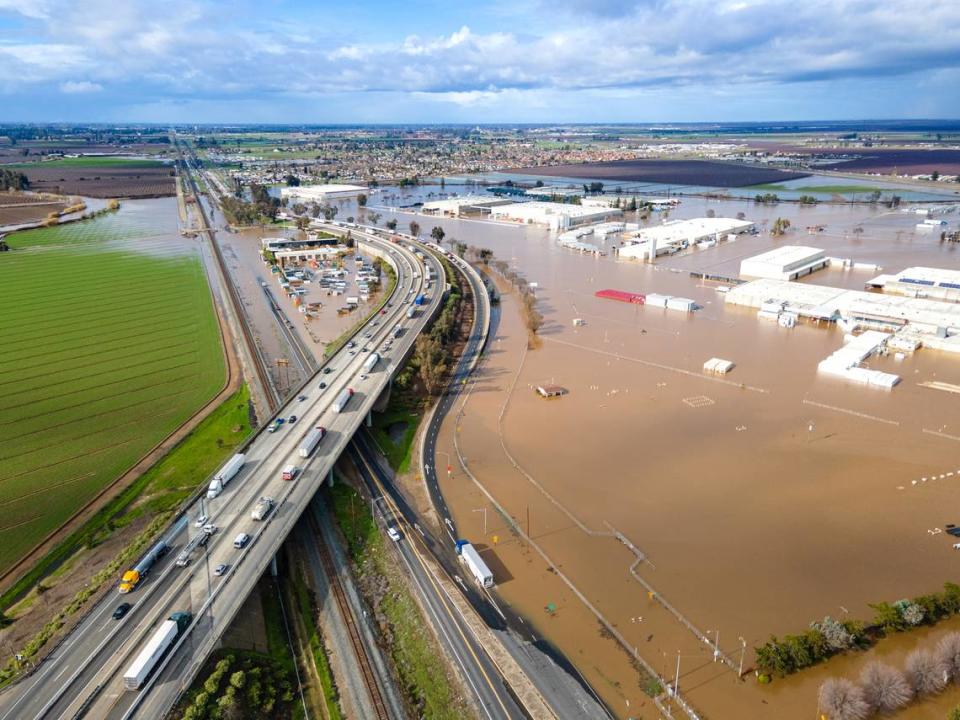
Most of the flooding came not from Black Rascal Creek, but from nearby Bear Creek, which flows from east to west through the middle of the city and crested several feet above its flood stage on Jan. 10. Black Rascal Creek is a tributary of Bear Creek, and the two streams merge just west of Merced.
Also hit by flooding this month was the unincorporated community of Planada, which was inundated when Miles Creek overflowed its banks east of Merced.
“While this (detention basin) wouldn’t have helped with the flooding seen in Planada, it could provide much needed protection to areas such as Franklin-Beachwood” on the western edge of Merced, said Mike North, a spokesperson for Merced County.
Flood control along Black Rascal and Bear creeks has been a concern in Merced County since the 1940s, and the proposed basin has been the subject of studies and evaluations since at least 2009. The project, which has a total price tag of about $35 million, is intended to offer enough capacity to handle once-every-200-years storm events.
North said construction is expected to begin in 2024.
What’s in the works?
In 2018, when the county considered an environmental assessment for the project, Public Works Director Dana Hertfelder reported to the Board of Supervisors that the basin “will substantially reduce downstream flooding along Bear Creek and provide flood protection for public safety, particularly in disadvantaged communities … (and) minimize property damage caused by flooding on residential and prime agricultural lands. …”
Levees around the perimeter of the 300-acre basin would hold up to 2,800 acre-feet of water during a 200-year storm event, and outlet structures would limit outflow into the creek channel to 3,000 cubic feet per second.
An acre-foot amounts to almost 326,000 gallons of water – enough to cover an acre of land with one foot of water. A flow of 3,000 cubic feet per second would be about 22,440 gallons of water flowing each second.
Merced is crisscrossed by waterways that make the city susceptible to flooding. A 2006 flood of the Franklin-Beachwood neighborhood at the western fringe of Merced sparked a multi-million-dollar lawsuit by residents against Merced County and the Merced Irrigation District.
The lawsuit claimed that the county and the irrigation district mishandled storm waters that flooded about 275 properties in the Franklin-Beachwood area as well as neighborhoods at the southwestern edge of the city.
The county reached a $5 million settlement in June 2012, and the Merced Irrigation District reached a separate settlement of $5 million a month later.
In the aftermath of that flood almost 13 years ago, the new storm basin is part of the Black Rascal Creek Flood Control Project being undertaken by Merced County with the goal of providing a greater degree of flood protection to disadvantaged communities, including about 6,000 residents in the Franklin-Beachwood neighborhood and another 79,000 people in disadvantaged portions of the city of Merced.
North said that in addition to the $9.7 million awarded to the county by the state in 2020, other money to pay for the project is coming from the U.S. Department of Agriculture as well as from the American Rescue Plan Act.
“An insane amount of water”
Flooding in Merced was relatively widespread along areas of Bear Creek, Merced Fire Chief Derek Parker told members of the Merced City Council in a Jan. 17 report, a week after the soaking storms.
“To be clear, we didn’t have a big blowout, we didn’t lose a bunch of land – it just came over the banks (of Bear Creek), and it came over the banks with a lot of ferocity,” Parker said. In the western area of Merced, along North Bear Creek Drive and Bear Creek Court, “the water came over the top of the banks and we had some walls in place, and they didn’t hold due to the amount of flow that we actually had.”
Parker added that city emergency crews also had to monitor some “minor overtopping” of Black Rascal Creek, which also passes through the city from east to west a short distance north of Bear Creek.
At the western edge of the city, along Cooper Avenue, an industrial area along the south bank of Black Rascal Creek – including an electrical substation – was inundated by floodwaters from the stream.

The city’s flood woes from overflowing streams was compounded by even more rainfall. “There was a lot of localized flooding that happened right at that same time that water was coming over the edge of the creek,” Parker said, “because we had a thundercell that was over the top and it was impacting the roads, it was impacting communities all over town.”
One of those neighborhoods was near downtown Merced, at Bear Creek Drive and Montana Avenue, “an area where we actually had the creek, for a small period, exit its banks onto South Bear Creek (Drive),” Parker said. “Growing up here, never, ever would I have thought the water in this area would be coming onto the roadway. It was an insane amount of water.”
At the Riviera Holiday mobile home park, floodwaters from Bear Creek spilled over the banks and was funneled by streets into the park. “As these trailers were lifted, either on jacks or blocks and they have a skirt around them, you can see how the skirts were moved around,” Parker said. “Sometimes it looks like it was angry when it went through there and moved those things around.”
Parker said the volume of water flowing down Bear Creek Drive amounted to as much as 2,000 cubic feet per second – or almost 15,000 gallons per second – at the height of the creek’s overflow, “which is how cars were raised up and put on top of fire hydrants and moved off the street into houses.”
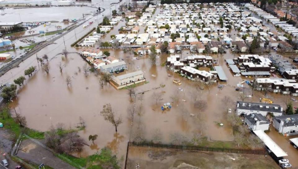
Merced is divided into 13 different evacuation zones, eight of which were activated to receive evacuation warnings or orders on Jan. 9 and 10 encompassing about 5,000 homes, Parker said. More than 600 residents and 26 businesses were displaced by flooding, and about 500 people living in Evacuation Area 1 – including the neighborhoods around the mobile home park at West 16th Street and Highway 59 – needed rescuing by emergency crews.
Preventing a repeat
Given the frequency of flooding that has happened in the past – in 1937, 1950, 1955, 1969, 1997, 1998, 2002, 2005 and 2006 – both Merced city and county officials say more work is needed to prevent a repeat of what happened on Jan. 9 and 10.
“We’re going to focus on shoring up (Bear) Creek,” Merced City Councilmember Shane Smith said in response to Parker’s report. “It seems to me the creek needs to act as if this is not a 200-year flood but something we’re going to deal with more often.”
Mayor Matthew Serratto said the city may need to explore other means of coping with potential flooding. “If we have banks that are failing, do we try to shore them up and keep them up,” he asked, “or do we find potentially more creative … solutions with bike path rerouting (along Bear Creek) or different configurations of the roads on both sides?”
Portions of Bear Creek Drive along both the south and north side of the stream, and surrounding neighborhoods, experienced flooding as water topped the banks.
The new storm basin along Bear Creek represents a would-be solution to only one part of a complex array of issues confronting Merced. As the city has grown, the sheer age of much of the flood-protection system of levees and other structures in and around Merced may no longer be able to provide the necessary protection.
“It’s no secret. All of the infrastructure we’re dealing with in our region was installed in the 1950s,” Merced City Manager Stephanie Dietz said. “So we’re looking at all of this going, ‘Is this really going to work for us in the future?’”
“Unfortunately,” she added, “how can we use this incident as an opportunity to reinvest in the community more equitably to get the protection we do desperately need?”