
 Yahoo Movies
 There are 3 systems in the Atlantic basin. One could become Tropical Storm Bonnie soon
The Atlantic basin looks a lot more like late July than late June this week, with two systems under watch and tropical storm warnings in effect for Trinidad and Tobago.
The National Hurricane Center began issuing advisories on Potential Tropical Cyclone Two, which was expected to steer far from Florida, on Monday afternoon. The governments of Trinidad, Tobago and Grenada also issued tropical storm warnings.
As of the 5 p.m. update, the system was moving west-northwest at a fast 18 mph with 40 mph sustained winds. On this track, forecasters expect it will pass near or over the southern end of the Windward Islands on Tuesday and head for the northern Venezuelan coast by Wednesday or Thursday.
The system is expected to become Tropical Storm Bonnie at some point Tuesday and could strengthen to a hurricane before it approaches Nicaragua on Saturday.
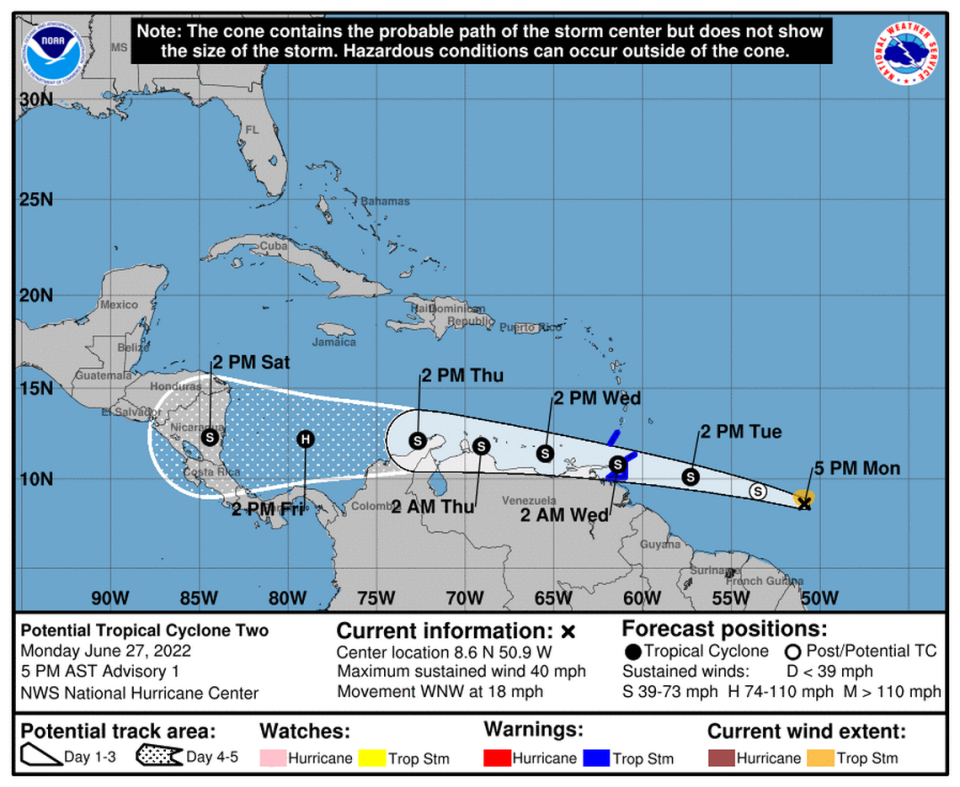
“Heavy rainfall is expected over the Windward Islands and northeastern Venezuela Tuesday night and into Wednesday,” the hurricane center’s advisory reads.
Storm models show this system staying south, even if it does form into a depression or tropical storm. Forecasters predict that a strong ridge of high pressure over Florida is likely to ward the system off.
The other two systems forecasters are watching, one in the northern Gulf of Mexico and another in the eastern Atlantic, have a low 20% chance of formation through the next five days.

The system in the northern Gulf of Mexico near Louisiana is forecast to move west-southwest and approach the coasts of southern Texas and northeastern Mexico during the next few days.
As for the tropical wave in the eastern Atlantic that is several hundred miles southwest of the Cabo Verde Islands, forecasters say it could see some gradual development later this week as it quickly moves west-northwest over the Atlantic.
How busy will hurricane season be this year? NOAA predicts ‘above average’ with 6 to 10
